Owl
| coat of arms | Germany map | |
|---|---|---|

|
Coordinates: 50 ° 10 ' N , 7 ° 46' E |
|
| Basic data | ||
| State : | Rhineland-Palatinate | |
| County : | Rhein-Lahn district | |
| Association municipality : | Loreley | |
| Height : | 275 m above sea level NHN | |
| Area : | 2.65 km 2 | |
| Residents: | 188 (Dec. 31, 2019) | |
| Population density : | 71 inhabitants per km 2 | |
| Postal code : | 56357 | |
| Area code : | 06771 | |
| License plate : | EMS, DIZ, GOH | |
| Community key : | 07 1 41 004 | |
| LOCODE : | DE A57 | |
| Association administration address: | Dolkstrasse 3 56346 St. Goarshausen |
|
| Website : | ||
| Local Mayor : | Ralph-Dietmar Seitz | |
| Location of the local community Auel in the Rhein-Lahn district | ||
Auel is a municipality in the Rhein-Lahn district in Rhineland-Palatinate . It belongs to the Verbandsgemeinde Loreley , which has its administrative headquarters in St. Goarshausen .
geography
Auel is located in the western Hintertaunus . The Rödelbach, Schönebeck and Theismühle residential areas also belong to Auel .
history
In 1250 the place is first mentioned as Owele . At that time it was already under the rule of the Counts of Katzenelnbogen. After their extinction, sovereignty passed to the Landgraves of Hesse in 1479 . The Reformation was introduced as early as 1528 by Landgrave Philipp von Hessen . From 1567 the place belonged to Hessen-Rheinfels, from 1583 to Hessen-Kassel. From 1806 Auel was part of the Duchy of Nassau , which was annexed by Prussia in 1866 . After the First World War, the place belonged to the French zone of occupation until 1929.
The place was captured by American troops on March 26, 1945.
Since 1946 the place has been part of the state of Rhineland-Palatinate .
There were many different places to which Auel was church-bound. So you were first forced to visit the church in Ruppertshofen, four kilometers away . Later they came to the agreement that the inhabitants Aueler the church in "only" two kilometers away Lierschied could visit because you then and now does not have a church. Today the place is subordinate to the Protestant parish of St. Goarshausen ; however, services are held once a month in the parish hall in Auel.
Population development
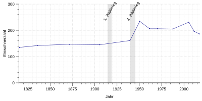
Accurate records are not available for the early years of the small village. But one can say that the population should have been limited to only a few farmers. In the following years the growth of the small community was also slow. The first verifiable records come from the years between 1639 and 1693. In the 17th century Auel had between 45 and 65 inhabitants and in 1783 123 inhabitants.
- Statistics on population development
The development of the population of Auel, the values from 1871 to 1987 are based on censuses:
|
|
politics
Municipal council
The municipal council in Auel consists of six council members, who were elected by a majority vote in the local elections on May 26, 2019 , and the honorary local mayor as chairman.
mayor
The local mayor of Auel is Ralph-Dietmar Seitz. In the direct election on May 26, 2019, he was re-elected with 91.82% of the vote.
coat of arms
|
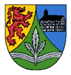
Blazon : “Split of gold and blue by a curved green tip, inside a silver wavy bar, covered with a three-leaved silver branch; in front a blue-armored and tongued red lion to the left , behind a silver half-timbered house with a black roof, on it a black bell tower on the right. "
The coat of arms was approved in 1985. |
|
| Founding of the coat of arms: The story that describes this coat of arms is related to the former county of Katzenelnbogen . The red lion on a golden background was the coat of arms of the counts and stands for the fact that Auel belonged to this county at that time. The half-timbered house on a blue background is the town's landmark. It used to be a town hall, today, after renovation, it is the community's fire station . Last to be mentioned is the three-leaved silver branch on a green background, surrounded by a wavy bar, which shows several hypotheses of interpretation. Since Auel was previously described as a village with large areas of grass that was rich in water, one can assume that the wavy lines symbolize the water and the green background the green landscape. |
Culture and sights
Buildings
Two buildings can be counted among the sights in Auel:
- the old City Hall
- the village square with the village fountain
The old town hall, which is also known colloquially as Backes (= Backhaus ), was first mentioned under this name in 1822 and is therefore one of the oldest buildings in Auel. The bell tower was mentioned for the first time in 1865, the bell belonging to it bears the inscription: "God alone honor in 1668". In 1926 a fire destroyed the house, but it was rebuilt in the same year. In the 1970s, the volunteer fire department moved into the building; In 1981/82 the old town hall was renovated and placed under monument protection. As part of the village renewal (1983/84), the Rhein-Lahn district administration classified the building as around the 17th or 18th century.
The old village well, which has been the property of the community since 1912, used to be an important water dispenser for the village. Today the fountain is still used regularly in the summer months.
societies
The mixed choir MGV "Loreley" Auel was founded in April 1904. Despite the small number of inhabitants, the number of members or active singers is around 30 people. In honor of the 100th anniversary, the choir was awarded the Zelter plaque .
The Auel Table Tennis Club (TTC Auel) was founded on May 5, 1959. He plays in the 2011/2012 championship round for the first time in club history with only one men's team. This is registered in the 2nd district class (season C) in the district "Südlicher Westerwald / Rhein-Lahn".
Volunteer firefighter
The roots of the volunteer fire brigade in Auel can be traced back to 1882. At this point in time a fire brigade was supposed to be established, but this did not materialize due to the small number of inhabitants. The actual year the volunteer fire brigade was founded is 1904.
Regular events
- Carnival session in February
- Club championships of the TTC
- Village festival in August
- Martinszug in November
- Christmas market in November
- Silver sterling drink
Economy and Transport
In contrast to earlier times, the landscape of Auels is no longer characterized by farms. With two exceptions, all farms were abandoned. There are only one part-time business and one full-time business. Despite all this, the landscape is still very rural, as there are still large areas of cultivation.
The traffic connections in Auel are limited to two streets. The district road K87 and the federal road 274 .
Web links
- Local community Auel on the website of the Verbandsgemeinde Loreley
- Historical information about Auel on regionalgeschichte.net
Individual evidence
- ↑ State Statistical Office of Rhineland-Palatinate - population status 2019, districts, communities, association communities ( help on this ).
- ↑ State Statistical Office Rhineland-Palatinate (ed.): Official directory of the municipalities and parts of the municipality. Status: January 2019 [ Version 2020 is available. ] . S. 68 (PDF; 3 MB).
- ↑ State Statistical Office Rhineland-Palatinate: Regional data.
- ^ The Regional Returning Officer Rhineland-Palatinate: Municipal Council Election 2019 Auel. Retrieved November 2, 2019 .
- ^ The State Returning Officer Rhineland-Palatinate: direct elections 2019. see Loreley, Verbandsgemeinde, first line of results. Retrieved November 2, 2019 .


