
Top iron
| coat of arms | Germany map | |
|---|---|---|

|
Coordinates: 50 ° 20 ' N , 8 ° 5' E |
|
| Basic data | ||
| State : | Rhineland-Palatinate | |
| County : | Rhein-Lahn district | |
| Association municipality : | Aar facility | |
| Height : | 135 m above sea level NHN | |
| Area : | 4.54 km 2 | |
| Residents: | 753 (Dec. 31, 2019) | |
| Population density : | 166 inhabitants per km 2 | |
| Postal code : | 65558 | |
| Area code : | 06430 | |
| License plate : | EMS, DIZ, GOH | |
| Community key : | 07 1 41 102 | |
| LOCODE : | DE OZB | |
| Association administration address: | Burgstrasse 1 56368 Katzenelnbogen |
|
| Website : | ||
| Local Mayor : | Peter Pelk ( SPD ) | |
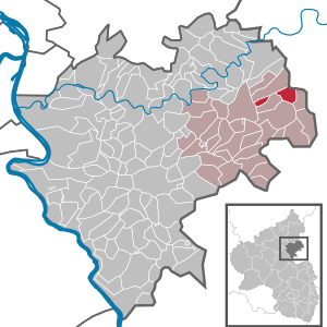
| Location of the local community Oberneisen in the Rhein-Lahn district | ||
  |
||

Oberneisen is a municipality in the Rhein-Lahn district in Rhineland-Palatinate . It belongs to the municipality of Aar-Einrich .
geography
Oberneisen is located in the Taunus on the Aar creek eight kilometers south of Limburg an der Lahn . The Kaltenbach, which rises southeast of Kaltenholzhausen, and the smaller rivers Welsbach ( coming from Lohrheim ) and the Herbach ( coming from Mensfelden ) flow into the Aar in Oberneisen .
The Herbachmühle, Hof Seiters, Kalkwerk and Wirthmühle residential areas also belong to Oberneisen .
history
Oberneisen was first mentioned in 790 in a deed of donation from Charlemagne as Nasonia . This document documents the donation of Oberneisen and several surrounding villages to the Prüm Abbey . The place initially belonged to the Lahngau , later to the resulting county of Diez . From the 15th century, the sovereignty of Oberneisen split between the House of Nassau , Eppstein, Katzenelnbogen, the Landgraviate of Hesse and Kurtrier .
There is evidence of a court in Oberneisen for 1092 . At the end of the 13th century the place became the seat of a parish to which several surrounding villages belonged. From 1334, Schultheiße are guaranteed in Oberneisen, from 1412 Heimberger .
In the Thirty Years War the place was completely destroyed and later rebuilt. In 1806 the place was taken over by the Duchy of Nassau . After the annexation by Prussia, the place was part of the Prussian province of Hessen-Nassau from 1866 until the end of the Second World War and then came to the state of Rhineland-Palatinate .
The ruins of the Vogtei Oberneisen are located in Oberneisen. The knight dynasty held the bailiwick of St. Alban's Abbey in Mainz . Only the foundation walls of the once four-story tower have been preserved.
Between 1569 and 1620, the pastor gave school lessons in the village for the first time. The first schoolhouse was built in 1632 and until 1819 pupils from all over the parish went to it.
economy
A mill near Oberneisen is mentioned for the first time in 893.
The mining of Roteisenstein and phosphorite took place in the Oberneisen district . Mining must have existed before 1648, as the field name "In der Eysengrub" appeared for the first time in this year. Actual underground mining only began much later in the Rothenberg mine, from which the remains of industrial buildings and the dumps have still been preserved. Findings of manganese spar / raspberry spar ( rhodochrosite ) from the active mining period can be seen in Wiesbaden in the Wiesbaden Museum .
Population development
In 1529 29 households are guaranteed in Oberneisen, in 1588 119 inhabitants and in 1684 after the Thirty Years War only 15 inhabited houses. In 1716 the population is again given as 194, including two Jews for the first time. In 1800 there were 263 inhabitants. The population developed as follows in the 19th and 20th centuries: 1843: 456 inhabitants, 1927: 618 inhabitants, 1964: 822 inhabitants.
politics
Municipal council
The municipal council in Oberneisen consists of twelve council members, who were elected in a personalized proportional representation in the local elections on May 26, 2019 , and the honorary local mayor as chairman.
The distribution of seats in the municipal council:
| choice | SPD | GREEN | FBL | total |
|---|---|---|---|---|
| 2019 | 5 | 4th | 3 | 12 seats |
| 2014 | 8th | - | 4th | 12 seats |
| 2009 | 8th | - | 4th | 12 seats |
| 2004 | 8th | - | 4th | 12 seats |
- FBL; Freie Bürgerliste Oberneisen e. V.
mayor
Local mayor of Oberneisen is Peter Pelk (SPD). In the direct election on May 26, 2019, he was re-elected with a share of the vote of 52.41%.
Culture and sights
Buildings
Oberneisen Castle


The building, first mentioned in 1288, was the seat of the Knights of Nesen. The former western outer wall of the castle , a wall about 20 meters long, one meter thick and four stories high, which is located below the round church, has been preserved. The annual castle festival takes place in the courtyard.
Evangelical Church Oberneisen
Shortly before 881, the Prüm Abbey had a church built in Oberneisen. A successor building was consecrated between 1021 and 1031. This was followed by a church building, from which a late Romanesque tower that still exists today comes from. In 1525 the choir of the church was completely rebuilt, and in 1733 the entire building was completely renovated. In 1815 the building was demolished except for the old tower.
From 1816 to 1819 a new round church in the classical style, planned by Friedrich Ludwig Schrumpf and financed by the communities of Lohrheim, Netzbach and Oberneisen, was built. The Romanesque west tower was included in the new building. The church called “Dom des Aartal” is, as far as is known, the only round church north of the Alps with the altar in the middle of the room. The round altar consists of a marble slab with a diameter of 1.75 meters. The church has 250 seats on the ground floor and another 250 people in the gallery.
See also: List of cultural monuments in Oberneisen
Economy and Infrastructure
traffic
The B 54 runs west of the village in a north-south direction . The closest motorway junctions are on the A3 in Limburg, around nine kilometers northeast of Oberneisen. Oberneisen has a station on the Aartalbahn, which has been closed for passenger traffic on this section since 1986 . The closest ICE long-distance station is Limburg Süd station . .
tourism
In Oberneisen is just south of the former station Aartalbahn in the so-called Erbslöhalle the depot of the Working Group Aartalbahn from which trolley rides are offered on the Aartalbahn that are used every year by thousands of visitors.
Personalities
Sons and daughters of the church
- Johannes Martin Keller (born August 2, 1766; † February 24, 1829 in Büdingen), pastor, teacher and politician
- Hermann Becker (born October 24, 1895 - † October 4, 1976 in Diez), politician, member of the Rhineland-Palatinate state parliament
- Frank Puchtler (born April 1, 1962) District Administrator of the Rhein-Lahn district
Web links
- Internet presence of the local community Oberneisen
- Local community Oberneisen on the website of the municipality of Aar-Einrich
Individual evidence
- ↑ State Statistical Office of Rhineland-Palatinate - population status 2019, districts, communities, association communities ( help on this ).
- ↑ State Statistical Office Rhineland-Palatinate (ed.): Official directory of the municipalities and parts of the municipality. Status: January 1, 2017 [ Version 2020 is available. ] . S. 42 (PDF; 1.9 MB).
- ^ The Regional Returning Officer Rhineland-Palatinate: Local elections 2019, city and municipal council elections
- ^ The Regional Returning Officer Rhineland-Palatinate: direct elections 2019. see Aar-Einrich, Verbandsgemeinde, 27th line of results. Retrieved November 23, 2019 .
- ↑ arbeitskreis-aartalbahn.de: Official website of the Aartalbahn working group

Allendorf | Altendiez | Arzbach | Attenhausen | Auel | Aull | Bad Ems | Balduinstein | Becheln | Mountain | Berghausen | Berndroth | Bettendorf | Biebrich | Birlenbach | Bogel | Bornich | Braubach | Bremberg | Book | Burgschwalbach | Charlottenberg | Cramberg | Dachsenhausen | Dahlheim | Dausenau | Dessighofen | Dienethal | Diethardt | Diez | Dörnberg | Dornholzhausen | Dörscheid | Dörsdorf | Ebertshausen | Honor | Eisighofen | Endlichhofen | Eppenrod | Ergeshausen | Eschbach | Fachbach | Filsen | Flat | Fruit | Geilnau | Geisig | Gemmerich | Gückingen | Gutenacker | Hahnstätten | Hainau | Hambach | Heistenbach | Herald | Himmighofen | Hirschberg | Holzappel | Holzhausen an der Haide | Holzheim | Hömberg | Horhausen | Hunzel | Isselbach | Kaltenholzhausen | Kamp-Bornhofen | Kasdorf | Katzenelnbogen | Kaub | Kehlbach | Kemmenau | Kestert | Klingelbach | Kördorf | Lahnstein | Langenscheid | Laurenburg | Lautert | Liiffer | Lipporn | Lohrheim | Lollschied | Lykershausen | Marienfels | Miehlen | Mielle | Misselberg | Mittelfischbach | Mudershausen | Nassau | Nasta | Netzbach | Niederbachheim | Niederneisen | Niedertiefenbach | Niederwallmenach | Never | Nochern | Oberbachheim | Oberfischbach | Oberneisen | Obernhof | Obertiefenbach | Oberwallmenach | Oberwies | Oelsberg | Osterspai | Patersberg | Pohl | Prath | Reckenroth | Reichenberg | Reitzenhain | Rescue Grove | Rescues | Roth | Ruppertshofen | Sankt Goarshausen | Sauerthal | Scheidt | Schiesheim | Schönborn | Schweighausen | Seelbach | Singhofen | Steinsberg | Strüth | Sulzbach | Wasenbach | Weidenbach | Weinähr | Weisel | World destruction | Weyer | Winches | Winter advertising | Room difference