
Kaltenholzhausen
| coat of arms | Germany map | |
|---|---|---|

|
Coordinates: 50 ° 18 ' N , 8 ° 6' E |
|
| Basic data | ||
| State : | Rhineland-Palatinate | |
| County : | Rhein-Lahn district | |
| Association municipality : | Aar facility | |
| Height : | 235 m above sea level NHN | |
| Area : | 6.06 km 2 | |
| Residents: | 577 (Dec. 31, 2019) | |
| Population density : | 95 inhabitants per km 2 | |
| Postal code : | 65558 | |
| Area code : | 06430 | |
| License plate : | EMS, DIZ, GOH | |
| Community key : | 07 1 41 065 | |
| Association administration address: | Burgstrasse 1 56368 Katzenelnbogen |
|
| Website : | ||
| Local Mayor : | Christian Neeb | |
| Location of the local community Kaltenholzhausen in the Rhein-Lahn district | ||
  |
||

Kaltenholzhausen is a municipality in the Rhein-Lahn district in Rhineland-Palatinate . It belongs to the municipality of Aar-Einrich .
geography
Kaltenholzhausen is located on the Kaltenbach, an approximately seven kilometer long tributary of the Aar .
The Mecklenburger Hof residence also belongs to Kaltenholzhausen .
history
Kaltenholzhausen was formed from the two Fronhöfe Caldenbach and Holzhausen. The Caldenbach farm is mentioned for the first time in a document from 790 and was located on the site of today's Kirchgasse. The Holzhausen farm was located near today's motocross facility. Caldenbach was destroyed in 1393 and fell desolate . Thereupon the residents settled at Hof Holzhausen. Later the abandoned settlement with the new name "Kaltenholzhausen" was taken back into possession.
The settlement belonged to Zent Hahnstätten in Grafschaft Diez and took part in the change of ownership. A separate Heimberger for the place is first guaranteed in 1412. In 1632 there was a school of its own. In addition to agriculture, viticulture and, to a lesser extent, iron ore was also used until 1616.
27 households are guaranteed for 1526, 38 households for 1612 and 125 inhabitants for 1715.
Since 1806 the place belonged to the Duchy of Nassau , which was annexed by Prussia in 1866 . Since 1946 the place has been part of the state of Rhineland-Palatinate .
The population developed in the 19th and 20th centuries as follows: 1843: 443 inhabitants, 1927: 409 inhabitants, 1964: 445 inhabitants.
politics
Municipal council
The municipal council in Kaltenholzhausen consists of twelve council members, who were elected in a personalized proportional representation in the local elections on May 26, 2019 , and the honorary local mayor as chairman.
The distribution of seats in the municipal council:
| choice | SPD | CDU | FWG | BLK | total |
|---|---|---|---|---|---|
| 2019 | 1 | 4th | 5 | 2 | 12 seats |
| 2014 | 3 | 4th | 5 | - | 12 seats |
| 2009 | 4th | 3 | 3 | 2 | 12 seats |
| 2004 | 3 | 3 | 3 | 3 | 12 seats |
- FWG = Free Voting Community Kaltenholzhausen e. V.
- BLK = Citizens List Kaltenholzhausen e. V.
mayor
The local mayor of Kaltenholzhausen is Christian Neeb. In the direct election on May 26, 2019, he was elected with 73.61% of the vote, making him the successor to Roselinde Zimmermann (CDU).
Culture and sights
Sights of the village include the Evangelical Church , the motocross racing track, the deep wells of the two drinking water extraction systems for the village and the town hall of the local community, which was built on the site of the old school building from 1825. Previously, the upper floor of the bakery, built in 1829, served as the town hall.
What is striking about the rather small place is the large number of six running wells , which supplied the place with drinking water until 1910, when a water pipe was installed.
A chapel in Kaltenholzhausen is guaranteed for the year 1364. In 1895 it was demolished and a new church was built next to its old location. The organ and pulpit come from the old chapel.
In 1964 a new school was built, which served this purpose only briefly and henceforth as a village community center.
See also: List of cultural monuments in Kaltenholzhausen
photos
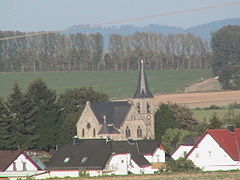
Protestant church
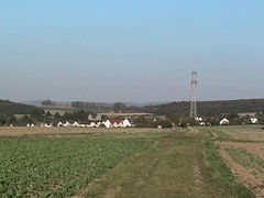
Kaltenholzhausen

Motocross racetrack

Deep well one of the two drinking water extraction systems for the place
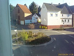
Roundabout / bus stop
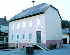
Town hall of the local community Kaltenholzhausen


Web links
- Pages of the local community Kaltenholzhausen
- Local community Kaltenholzhausen on the website of the community community Aar-Einrich
Individual evidence
- ↑ State Statistical Office of Rhineland-Palatinate - population status 2019, districts, communities, association communities ( help on this ).
- ↑ State Statistical Office Rhineland-Palatinate (ed.): Official directory of the municipalities and parts of the municipality. Status: January 2018 [ Version 2020 is available. ] . S. 42 (PDF; 2.2 MB).
- ^ The Regional Returning Officer Rhineland-Palatinate: Local elections 2019, city and municipal council elections
- ^ The Regional Returning Officer Rhineland-Palatinate: direct elections 2019. see Aar-Einrich, Verbandsgemeinde, 16th line of results. Retrieved November 21, 2019 .

Allendorf | Altendiez | Arzbach | Attenhausen | Auel | Aull | Bad Ems | Balduinstein | Becheln | Mountain | Berghausen | Berndroth | Bettendorf | Biebrich | Birlenbach | Bogel | Bornich | Braubach | Bremberg | Book | Burgschwalbach | Charlottenberg | Cramberg | Dachsenhausen | Dahlheim | Dausenau | Dessighofen | Dienethal | Diethardt | Diez | Dörnberg | Dornholzhausen | Dörscheid | Dörsdorf | Ebertshausen | Honor | Eisighofen | Endlichhofen | Eppenrod | Ergeshausen | Eschbach | Fachbach | Filsen | Flat | Fruit | Geilnau | Geisig | Gemmerich | Gückingen | Gutenacker | Hahnstätten | Hainau | Hambach | Heistenbach | Herald | Himmighofen | Hirschberg | Holzappel | Holzhausen an der Haide | Holzheim | Hömberg | Horhausen | Hunzel | Isselbach | Kaltenholzhausen | Kamp-Bornhofen | Kasdorf | Katzenelnbogen | Kaub | Kehlbach | Kemmenau | Kestert | Klingelbach | Kördorf | Lahnstein | Langenscheid | Laurenburg | Lautert | Liiffer | Lipporn | Lohrheim | Lollschied | Lykershausen | Marienfels | Miehlen | Mielle | Misselberg | Mittelfischbach | Mudershausen | Nassau | Nasta | Netzbach | Niederbachheim | Niederneisen | Niedertiefenbach | Niederwallmenach | Never | Nochern | Oberbachheim | Oberfischbach | Oberneisen | Obernhof | Obertiefenbach | Oberwallmenach | Oberwies | Oelsberg | Osterspai | Patersberg | Pohl | Prath | Reckenroth | Reichenberg | Reitzenhain | Rescue Grove | Rescues | Roth | Ruppertshofen | Sankt Goarshausen | Sauerthal | Scheidt | Schiesheim | Schönborn | Schweighausen | Seelbach | Singhofen | Steinsberg | Strüth | Sulzbach | Wasenbach | Weidenbach | Weinähr | Weisel | World destruction | Weyer | Winches | Winter advertising | Room difference