Aull
| coat of arms | Germany map | |
|---|---|---|

|
Coordinates: 50 ° 23 ' N , 8 ° 0' E |
|
| Basic data | ||
| State : | Rhineland-Palatinate | |
| County : | Rhein-Lahn district | |
| Association municipality : | Diez | |
| Height : | 117 m above sea level NHN | |
| Area : | 2.18 km 2 | |
| Residents: | 423 (Dec 31, 2019) | |
| Population density : | 194 inhabitants per km 2 | |
| Postal code : | 65582 | |
| Area code : | 06432 | |
| License plate : | EMS, DIZ, GOH | |
| Community key : | 07 1 41 005 | |
| LOCODE : | DE A75 | |
| Association administration address: | Louise-Seher-Strasse 1 65582 Diez |
|
| Website : | ||
| Local Mayor : | Michael Weimar | |
| Location of the local community of Aull in the Rhein-Lahn district | ||

Aull is a municipality in the Rhein-Lahn district in Rhineland-Palatinate . It belongs to the community of Diez .
geography
Aull is located in the east of Rhineland-Palatinate between Taunus and Westerwald an der Lahn , at the western end of the Limburg basin and borders the city of Diez in the south, the municipality of Gückingen (all Rhineland-Palatinate) in the north and the Limburg district in the east Staffel ( Hessen ). The Hambach flows through the village and flows into the Lahn here.
history
One explanation leads the name Aull back to the Latin aula (dt. Inter alia palace). It is more likely, however, that the name is derived from the Old High German ouwe , which means the "location of the settlement in the narrow valley by the water", from which today's Aull developed via the forms ouwelle , Auwell , Augell , Auell and Auel .
The history of Aull is closely connected to the old castle , which most likely dates back to the 12th or 13th century. On March 29, 1284, the Hofgut Aull belonging to the Old Castle was first mentioned in a document. This document documents the enfeoffment of the castle and the property belonging to it from the Count of Helfenstein to Otto von Diez .
The St. Jost Chapel was built around the year 1300, from which the surrounding towns were looked after for over 200 years. After the Reformation at the beginning of the 16th century and the conversion to Protestantism in 1564, the St. Jost Chapel was looked after from Diez . Plague epidemics raged in Aull several times , for example in the years 1349–50, 1364, 1574, 1606–07.
In 1618 a school was built. The acts of war during the Thirty Years' War destroyed and depopulated Aull to a large extent. After the end of the war, only six of 40 houses were habitable. The Thirty Years War led to the loss of the importance of viticulture , which never regained its original importance.
During the First Coalition War , Aull was on 19./20. Burned down by the French in April 1797, the St. Jost Chapel was also badly damaged, so that it was not renovated again and demolished in 1838. In 1806, with the formation of the Rhine Confederation , Aull came to the Duchy of Nassau , which was annexed by Prussia in 1866.
In 1912 a water pipe was built in Aull. The community has been connected to the electricity grid since 1913. Since 1946 the place has been part of the then newly formed state of Rhineland-Palatinate .
Flood on the Lahn
In February 1984 the water level of the Lahn reached a height of 7.68 meters in a flood of the century . In 1946 a water level of 7.95 meters was reached. The water level during the flood in 1909 was 7.48 meters. The normal level is 1.37 meters.
Population development
Before the Thirty Years' War, Aull had 40 houses, of which only six remained after the war. In 1831 Aull again had 31 houses with 170 inhabitants. The population rose to 260 by 1914 and to 273 by 1929. Aull had 55 houses at that time. 1964 the place had 349 inhabitants.
politics
Municipal council
The council in Aull consists of eight council members, who in the local elections on May 26, 2019 in a majority vote were elected, and the honorary mayor as chairman.
mayor
Michael Weimar is the local mayor of Aull. In the direct election on May 26, 2019, he was elected with a share of 66.81% of the vote and is the successor to Wolfgang Linden, who did not run again.
coat of arms
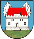
| Blazon : "In blue in front of two green trees on green ground a red roofed silver house with battlements." | |
| Justification of the coat of arms: So the shield in the community seals since 1816. Colors added. The house is supposed to represent the "castle" that still exists today, a former aristocratic residence, probably residential building by the Köth von Wanscheid who lived here and which stood out from the other houses in the small village due to its size and construction. The Nassau town did not have a court and therefore did not have its own seal before the 19th century. |
traffic
- Aull is on Landstrasse 319, which leads in the direction of Diez and Montabaur .
- The next motorway connections are Diez and Limburg Nord on the A3.
- Aull is connected by the bus line 450 (Montabaur- Nentershausen -Diez-Limburg) of the Rhein-Mosel-Bus company and the line 575 (Diez-Hambach-Nentershausen) of Martin Becker GmbH.
- The closest connection to local rail transport is at Diez train station, from where the RE 25 (Limburg-Diez-Bad Ems-Koblenz) and the RB 23 (Limburg-Diez- Bad Ems - Koblenz - Andernach - Mendig -Mayen Ost) run.
See also
literature
- Literature about Aull in the Rhineland-Palatinate State Bibliography
Web links
Individual evidence
- ↑ State Statistical Office of Rhineland-Palatinate - population status 2019, districts, communities, association communities ( help on this ).
- ^ The Regional Returning Officer Rhineland-Palatinate: Municipal Council Election 2019 Aull. Retrieved November 8, 2019 .
- ^ The Regional Returning Officer Rhineland-Palatinate: direct elections 2019. see Diez, Verbandsgemeinde, second line of results. Retrieved November 8, 2019 .
- ^ Karl Ernst Demandt and Otto Renkhoff : Hessisches Ortswappenbuch C. A. Starke Verlag, Glücksburg / Ostsee 1956, p. 164.


