
Sauerthal
| coat of arms | Germany map | |
|---|---|---|

|
Coordinates: 50 ° 5 ' N , 7 ° 49' E |
|
| Basic data | ||
| State : | Rhineland-Palatinate | |
| County : | Rhein-Lahn district | |
| Association municipality : | Loreley | |
| Height : | 208 m above sea level NHN | |
| Area : | 3.57 km 2 | |
| Residents: | 145 (Dec 31, 2019) | |
| Population density : | 41 inhabitants per km 2 | |
| Postal code : | 65391 | |
| Area code : | 06726 | |
| License plate : | EMS, DIZ, GOH | |
| Community key : | 07 1 41 122 | |
| Association administration address: | Dolkstrasse 3 56346 St. Goarshausen |
|
| Website : | ||
| Local Mayor : | Stefan Vohs | |
| Location of the local community Sauerthal in the Rhein-Lahn district | ||
  |
||

Sauerthal is a municipality in the Rhein-Lahn district in Rhineland-Palatinate . It belongs to the Verbandsgemeinde Loreley , which has its administrative headquarters in St. Goarshausen .
geography
The place is in the Tiefenbachtal in the Taunus directly on the Hessian border. Sauerthal also includes the residential areas Grube Nordstern, Hof Oders, Hof Sauerberg and the Sauerburg .
history

In 1291 the place "Surenburn" was mentioned for the first time when the rights and goods of the Counts of Sponheim were sold to the Count Palatine . Around 1355, Count Palatine Ruprecht built the Sauerburg , which was destroyed by troops of the French King Louis XIV in 1689 during the War of the Palatinate Succession .
Slate mining took place in several pits near the village . The deposits of the Kauber train z. B. in the pits Hundsberg (until 1926), Stirn, Leda, Fortuna and Jakobine & Persistent (all until 1950), Nordstern & Marcellus and Wilhelmine (both until 1953). With the closure of the Heppenberg mine (1975), slate mining in Sauerthal ended.
The imperial barons of Sickingen inherited the rule in 1692, which after a brief French occupation came into the possession of the Duchy of Nassau in 1806 through the Rhine Confederation Act . In the Duchy of Nassau it was assigned to the Caub office, which was added to the St. Goarshausen office in 1816 . With a letter of October 25, 1808, Nassau also lifted the patrimonial jurisdiction of the Count of Sickingen. However, this was not enforced. In fact, the count's court clerk exercised the jurisdiction of the first instance until his death in 1818. A settlement was reached on December 15, 1815 about the amount of compensation and the assumption of the debts of the Count of Sickingen by the Duchy . After further negotiations, on December 17, 1825, Nassau unilaterally set a compensation pension of 267.33 guilders . The heavily indebted count refused. After Franz von Sickingen, the last of his family, died on November 25, 1834, the sum was paid to his creditor, Baron Karl von Gemmingen, on May 1, 1841.
After the annexation of the Duchy of Nassau in 1866 by the Kingdom of Prussia , the place became Prussian.
After the First World War, during the Allied occupation of the Rhineland , the town was located in a narrow corridor between the bridgeheads on the right bank of the Rhine between the Americans around Koblenz and the French around Mainz. Until the military occupation by France in 1923, the area existed as a so-called free state bottleneck .
After the Second World War, the place was in the French occupation zone directly on the zone border with Hesse, which was occupied by the Americans, and has been part of the state of Rhineland-Palatinate since 1946 .
politics
Municipal council
The council in Sauerthal consists of six council members, who in the local elections on May 26, 2019 in a majority vote were elected, and the honorary mayor as chairman.
mayor
The local mayor of Sauerthal is Stefan Vohs. No candidate ran for the direct election on May 26, 2019. Vohs was re-elected by the municipal council in the constituent meeting on June 24, 2019.
Culture and sights
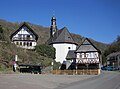
- Church of St. Anna
- Neo-Gothic tomb of Count Franz von Sickingen († 1834) in the Sauerthal cemetery, erected by the historian and teacher Karl Rossel
- The Sauerbrunnen in the town center
- The Sauerburg stands above the place .
Sauerthal

Filial church St. Anna

Grave of Imperial Count Franz von Sickingen
(† 1834)
The Sauer Brunnen
(in the village)
The Sauerburg
(above the town)


.jpg)
.JPG)

Transport and infrastructure
Sauerthal is a functional exclave; the place can only be reached by road from Hessen. The district road 101 leads across the border to Hesse as district road 623 and connects the place with the national road network.
Although Sauerthal, like the rest of the Rhein-Lahn district, actually belongs to the Rhein-Mosel transport association (VRM), the place is served exclusively by a line of the Hessian Rhein-Main transport association (RMV), which connects the place with Lorch. The children from Sauerthal attend schools in Hessen.
See also
Web links
- Local community Sauerthal on the website of the Verbandsgemeinde Loreley
- Historical photo of the Heppenberg mine railway, Rudi Spreitzer archive, Sauerthal
- Historical information about Sauerthal at regionalgeschichte.net
Individual evidence
- ↑ State Statistical Office of Rhineland-Palatinate - population status 2019, districts, communities, association communities ( help on this ).
- ↑ State Statistical Office Rhineland-Palatinate (ed.): Official directory of the municipalities and parts of the municipality. Status: January 2018 [ Version 2020 is available. ] . S. 46 (PDF; 2.2 MB).
- ^ Frank and Ralf Staudt Slate mining around Kaub in: Bergbau im Rhein-Lahn-Kreis , publisher: Rhein-Lahn district administration, 1994
- ↑ Roofing slate mining in West Taunus Uwe Nohl
- ^ Harry Münzing: The mediatization of the former imperial directors and imperial knights in the Duchy of Nassau. Diss., 1980, pp. 118-119, 161-162
- ^ The Regional Returning Officer Rhineland-Palatinate: Local council election 2019 Sauerthal. Retrieved November 2, 2019 .
- ^ The Regional Returning Officer Rhineland-Palatinate: direct elections 2019. see Loreley, Verbandsgemeinde, 19th line of results. Retrieved November 2, 2019 .
- ↑ Information from the Loreley Association - Official Announcements: Announcement. Edition 27/2019. Linus Wittich Medien GmbH, July 1, 2019, accessed on November 2, 2019 .

Allendorf | Altendiez | Arzbach | Attenhausen | Auel | Aull | Bad Ems | Balduinstein | Becheln | Mountain | Berghausen | Berndroth | Bettendorf | Biebrich | Birlenbach | Bogel | Bornich | Braubach | Bremberg | Book | Burgschwalbach | Charlottenberg | Cramberg | Dachsenhausen | Dahlheim | Dausenau | Dessighofen | Dienethal | Diethardt | Diez | Dörnberg | Dornholzhausen | Dörscheid | Dörsdorf | Ebertshausen | Honor | Eisighofen | Endlichhofen | Eppenrod | Ergeshausen | Eschbach | Fachbach | Filsen | Flat | Fruit | Geilnau | Geisig | Gemmerich | Gückingen | Gutenacker | Hahnstätten | Hainau | Hambach | Heistenbach | Herald | Himmighofen | Hirschberg | Holzappel | Holzhausen an der Haide | Holzheim | Hömberg | Horhausen | Hunzel | Isselbach | Kaltenholzhausen | Kamp-Bornhofen | Kasdorf | Katzenelnbogen | Kaub | Kehlbach | Kemmenau | Kestert | Klingelbach | Kördorf | Lahnstein | Langenscheid | Laurenburg | Lautert | Liiffer | Lipporn | Lohrheim | Lollschied | Lykershausen | Marienfels | Miehlen | Mielle | Misselberg | Mittelfischbach | Mudershausen | Nassau | Nasta | Netzbach | Niederbachheim | Niederneisen | Niedertiefenbach | Niederwallmenach | Never | Nochern | Oberbachheim | Oberfischbach | Oberneisen | Obernhof | Obertiefenbach | Oberwallmenach | Oberwies | Oelsberg | Osterspai | Patersberg | Pohl | Prath | Reckenroth | Reichenberg | Reitzenhain | Rescue Grove | Rescues | Roth | Ruppertshofen | Sankt Goarshausen | Sauerthal | Scheidt | Schiesheim | Schönborn | Schweighausen | Seelbach | Singhofen | Steinsberg | Strüth | Sulzbach | Wasenbach | Weidenbach | Weinähr | Weisel | World destruction | Weyer | Winches | Winter advertising | Room difference