
Kasdorf
| coat of arms | Germany map | |
|---|---|---|

|
Coordinates: 50 ° 12 ' N , 7 ° 47' E |
|
| Basic data | ||
| State : | Rhineland-Palatinate | |
| County : | Rhein-Lahn district | |
| Association municipality : | Nasta | |
| Height : | 298 m above sea level NHN | |
| Area : | 4.06 km 2 | |
| Residents: | 239 (Dec. 31, 2019) | |
| Population density : | 59 inhabitants per km 2 | |
| Postal code : | 56357 | |
| Area code : | 06772 | |
| License plate : | EMS, DIZ, GOH | |
| Community key : | 07 1 41 067 | |
| Association administration address: | Bahnhofstrasse 1 56355 Nastätten |
|
| Website : | ||
| Local Mayor : | Timo Bremser | |
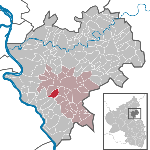
| Location of the local community of Kasdorf in the Rhein-Lahn district | ||
  |
||

Kasdorf is a municipality in the Blauer Ländchen in the Rhein-Lahn district in Rhineland-Palatinate . It belongs to the association of Nastaetten .
geography
Kasdorf lies between the Rhine and Lahn im Taunus (western Hintertaunus ).
history
The place was first mentioned in 1262 as "Chastraffa". With the death of Philip I in 1479, the count of Katzenelnbogen ended . Their lower counties fell to the Landgrave of Hesse by inheritance. Since 1557 the area was owned by Hessen-Kassel . Already in (and before) the 16th century there was intensive sheep breeding and the fabrics woven from the wool were sold at home and abroad as particularly high-quality "Nastätter cloth". From around 1590 flax cultivation was an important source of income. The flax was also used to make cloth, which was often dyed blue. This is the origin of the name Blue Land for the area.
From 1806 to 1813 the area was under French administration. After the Congress of Vienna (1815), the region and with it what was then Casdorf was assigned to the Duchy of Nassau on the basis of an exchange contract in 1816 . As a result of the so-called German War , the Duchy of Nassau was annexed by the Kingdom of Prussia in 1866 .
After the First World War , Kasdorf was occupied until the French withdrew in 1929. The current name Kasdorf has been valid since 1937. After the Second World War , Kasdorf was in the French occupation zone and has been part of the then newly formed state of Rhineland-Palatinate since 1946 .
politics
Municipal council
The council in Kasdorf consists of six council members, who in the local elections on May 26, 2019 in a majority vote were elected, and the honorary mayor as chairman.
mayor
The local mayor of Kasdorf is Timo Bremser. In the direct election on May 26, 2019, he was re-elected with 88.28% of the vote.
coat of arms
|
|
Blazon : "A green clover leaf on a silver background." |
| Reasons for the coat of arms: The shamrock was supposed to express the importance of agriculture in the fertile Kasdorfer Mulde. The point in time since the municipality has carried the coat of arms is no longer known. In any case, it was already listed in a seal at the time of the Duchy of Nassau. |
See also
Web links
Individual evidence
- ↑ State Statistical Office of Rhineland-Palatinate - population status 2019, districts, communities, association communities ( help on this ).
- ^ The Regional Returning Officer Rhineland-Palatinate: Municipal Council Election 2019 Kasdorf. Retrieved November 6, 2019 .
- ^ The Regional Returning Officer Rhineland-Palatinate: direct elections 2019. see Nastätten, Verbandsgemeinde, twelfth line of results. Retrieved November 6, 2019 .

Allendorf | Altendiez | Arzbach | Attenhausen | Auel | Aull | Bad Ems | Balduinstein | Becheln | Mountain | Berghausen | Berndroth | Bettendorf | Biebrich | Birlenbach | Bogel | Bornich | Braubach | Bremberg | Book | Burgschwalbach | Charlottenberg | Cramberg | Dachsenhausen | Dahlheim | Dausenau | Dessighofen | Dienethal | Diethardt | Diez | Dörnberg | Dornholzhausen | Dörscheid | Dörsdorf | Ebertshausen | Honor | Eisighofen | Endlichhofen | Eppenrod | Ergeshausen | Eschbach | Fachbach | Filsen | Flat | Fruit | Geilnau | Geisig | Gemmerich | Gückingen | Gutenacker | Hahnstätten | Hainau | Hambach | Heistenbach | Herald | Himmighofen | Hirschberg | Holzappel | Holzhausen an der Haide | Holzheim | Hömberg | Horhausen | Hunzel | Isselbach | Kaltenholzhausen | Kamp-Bornhofen | Kasdorf | Katzenelnbogen | Kaub | Kehlbach | Kemmenau | Kestert | Klingelbach | Kördorf | Lahnstein | Langenscheid | Laurenburg | Lautert | Liiffer | Lipporn | Lohrheim | Lollschied | Lykershausen | Marienfels | Miehlen | Mielle | Misselberg | Mittelfischbach | Mudershausen | Nassau | Nasta | Netzbach | Niederbachheim | Niederneisen | Niedertiefenbach | Niederwallmenach | Never | Nochern | Oberbachheim | Oberfischbach | Oberneisen | Obernhof | Obertiefenbach | Oberwallmenach | Oberwies | Oelsberg | Osterspai | Patersberg | Pohl | Prath | Reckenroth | Reichenberg | Reitzenhain | Rescue Grove | Rescues | Roth | Ruppertshofen | Sankt Goarshausen | Sauerthal | Scheidt | Schiesheim | Schönborn | Schweighausen | Seelbach | Singhofen | Steinsberg | Strüth | Sulzbach | Wasenbach | Weidenbach | Weinähr | Weisel | World destruction | Weyer | Winches | Winter advertising | Room difference