Dörscheid
| coat of arms | Germany map | |
|---|---|---|
|
Coordinates: 50 ° 6 ' N , 7 ° 46' E |
|
| Basic data | ||
| State : | Rhineland-Palatinate | |
| County : | Rhein-Lahn district | |
| Association municipality : | Loreley | |
| Height : | 340 m above sea level NHN | |
| Area : | 8.65 km 2 | |
| Residents: | 394 (Dec. 31, 2019) | |
| Population density : | 46 inhabitants per km 2 | |
| Postal code : | 56348 | |
| Area code : | 06774 | |
| License plate : | EMS, DIZ, GOH | |
| Community key : | 07 1 41 031 | |
| Association administration address: | Dolkstrasse 3 56346 St. Goarshausen |
|
| Website : | ||
| Local Mayor : | Martin Lübke | |
| Location of the municipality Dörscheid in the Rhein-Lahn district | ||
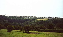
Dörscheid is a municipality in the Rhein-Lahn district in Rhineland-Palatinate . It belongs to the Verbandsgemeinde Loreley , which has its administrative headquarters in St. Goarshausen .
geography
Geographical location
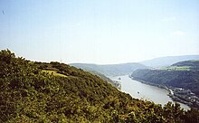
Dörscheid is located in the western Hintertaunus , on the right bank of the Rhine at 340 m above sea level. NHN high above the steep slopes of the Rhine Valley , which flows past only 750 meters away, on the Taunus heights above Kaub . The distance to the Loreley rock is about four kilometers (as the crow flies). The district of Dörscheid also includes the Kreuzwald as an exclave , located in the east on the other side of the Tiefenbach between Weisel and the Hessian Ransel .
Neighboring communities
Kaub is one kilometer away in the south, Weisel three kilometers further east and Bornich is two kilometers north as the crow flies. Because the Dörscheid community forest is an exclave east of Weisel, Dörscheid still has Lipporn and Lorch as neighbors.
history
Around the 9th century, the exposed Rheinhöhe opposite the old Oberwesel was settled. Today's Dörscheid developed from this. Its name has hardly changed over the centuries, because it is mentioned in documents as early as 1250 as "Derscheid". The name changed from Derscheid , to Niedern- and Obernderscheit , Obernderst and Niedernderst , Nidder- and Altdörscheid (1640), then only one place: Derscheid (t) , Dörschied , Dörscheid (see below ).
The village was owned by the Lords of Falkenstein , which Ludwig II , Elector Palatinate, acquired in 1277. This created the electoral Palatinate exclave that existed until 1803 on the right bank of the Rhine, which also included Sauerthal , Weisel and “both Dörscheid” as the sub-district of Kaub . In the Middle Ages two districts, the 1359 as passed Niedern and - Upper Santander log , 1452 Obernderst and Niedernderst be mentioned. The curiosity is owed to a cartographer who, instead of knowing his own location, only had an outdated map as a template, that on his depiction of the attack by the French on the Rheinfels fortress of 1758 both Dörscheid were drawn again, because in 1640 the last time from a united community of Nidder - and Altdörscheid reported.
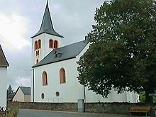
The raging of the Thirty Years' War had taken its toll on the already decimated Dörscheiders. As early as 1597, the plague had carried away 89 residents. In 1612 the epidemic returned and claimed another 80 victims, so that both Dörscheid only had 56 inhabitants in 1620. Affected by famine and renewed ravages of the plague in 1622, the few survivors were probably only able to create a Dörscheid out of the ruins. After the end of the war, they turned to their sovereign, the Count Palatine, with a petition that the church “had been completely ruined on the roof and chairs by various military camps and passages, also other issuing storm winds”, and they “also by the protracted, highly harmful one War system so utterly exhausted and impoverished ”that apart from the hand and hand front nothing could contribute to the restoration. The church from the early 14th century was then restored in 1668, whereby the arched windows that are still visible today were broken into the masonry and the probably destroyed cross vault of the nave was replaced with a flat ceiling. The ogival vaulted choir was also retained during later renovations, only the upper part of the tower was changed in 1897 due to its disrepair. With its almost 700-year-old church, which has also had an organ since 1822, Dörscheid has one of the oldest churches in the region. Until the Reformation, Dörscheid was parish in Weisel , then the church register reports:
“In the year of salvation 1591 under Count Palatine Johann Casimir , The 30 Years War is the parish, which previously had only one school, was ordered to be a parish and school, and dominus Johan. Pistorius was the first deacon and schoolmaster to Derscheit. "
But most pastors did not last long in the poorly paid position and in a parsonage where they still had to teach school themselves. The priest at the time, Abegg, raised the capital required to build a new rectory in 1738 by preaching across the country, especially in Holland, and asking for charitable donations for his project. So it is little wonder that some pastors at least abandoned their teaching post. Since classes were only taught from Martini to Shrovetide anyway , they recruited assistants for the so-called thing school , often “disused soldiers, rotten craftsmen” or people who were unable to do any other work due to physical disabilities. “What a lesson that may have been!” Writes teacher Reichard looking back in 1846. He also reports of illiteracy and widespread superstition among the Dörscheiders, who still feared “secret arts” and who, when they were ill, brought up old women with their sayings.
Only Karl Wilhelm Pfarrius, the second of the pastors in office in three generations in Dörscheid, achieved the final separation of school and pastoral office, and “on December 12, 1810, a ducal-Nassau consistory in Wiesbaden approved the previous winter school in To transform Derscheidt into a permanent school ”. These acquired the community for 450 guilders from the Kauber bailiff a house, were accommodated in the school hall and teacher's apartment. For reasons of space, the 40 students had to move into the town hall, which had been built three years earlier, from 1860, which led to some annoyance, as the community hall was also used for non-school events. When the number of pupils grew to over 60 in the 1920s, a decision was made to build a school, but this was postponed due to the financial situation. It was not until 1964 that Dörscheid received the long-awaited school for his 46 students. This was the last "dwarf school" established by the district. Since August 1, 1972, all children have been attending the Loreley School in St. Goarshausen- Heide.
Dörscheid's population grew continuously from 268 in 1808 to 409 in 1895. After a temporary decline, the municipality has reached this number again today.
politics
Municipal council
The council in Dörscheid consists of eight council members, who in the local elections on May 26, 2019 in a majority vote were elected, and the honorary mayor as chairman.
List of mayors
| 1826-1848 | Mayor Vogel |
| 1848-1866 | Mayor Vogel |
| 1866-1883 | Peter Wilhelm Thomas |
| 1883-1897 | Arnold Jakob Huth |
| 1897-1906 | Anton Volk |
| 1906-1912 | Peter Napp |
| 1912-1924 | Heinrich Jakob Thomas |
| 1924-1940 | Adolf Volk |
| 1940-1945 | Otto Volk |
| 1945-1948 | Wilhelm Federhen |
| 1948-1950 | Karl Napp |
| 1950-1962 | Ewald Weise |
| 1962-1975 | Edwin Napp |
| 1975-1989 | Adolf Lenz |
| 1989-1999 | Karl Loos |
| 1999-2004 | Klaus Linkenbach |
| 2004-2019 | Donald Thomas |
| from 2019 | Martin Lübke |
In the direct election on May 26, 2019, Martin Lübke was elected with 60.85% of the vote.
coat of arms
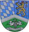
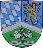
| Blazon : “Shield divided by flat silver rafters; split above; roughened diagonally to the right at thetop right of blue and silver, at the top left in blue a red-armored and tongued red-crowned golden lion, accompanied by golden shingles; below, in green, a silver bunch of grapes with two silver leaves and a horizontal wavy band. " | |
|
Reasons for the coat of arms: In the upper half of the coat of arms , on the one hand, the blue-silver diamonds refer to Dörscheid's over 500-year membership in the Electoral Palatinate , and on the other hand, the lion to the Duchy of Nassau , which shaped the entire “Ländchen” during its 60-year sovereignty. The motif on the lower half of the coat of arms characterizes Dörscheid as a viticulture community.
The coat of arms was approved on June 28, 1985. |
tourism
Dörscheid is located on the Rheinsteig and is therefore popular with hikers. From several vantage points you have a wonderful view of the Hunsrück and the Loreley community . A special feature is the 349 meter high "Schwedenschanze", a ridge near Dörscheid, which offers a view of 34 villages in the Hunsrück, Taunus and Rhine Valley .
Economy and Infrastructure
As everywhere, the traditionally predominant branches of business agriculture and viticulture have lost their importance. In addition to four commercial enterprises, only two full-time farmers operate in Dörscheid. Viticulture on around 20 hectares of land-adjusted cultivation area is also mostly operated as a sideline.
Since 1868 in the pit Kreuzberg in Creutzwald -powered slate mining was discontinued 1980th
There are currently three catering establishments in the village.
See also
Web links
- Local municipality Dörscheid on the website of the Verbandsgemeinde Loreley
- Historical information about Dörschied at regionalgeschichte.net
Individual evidence
- ↑ State Statistical Office of Rhineland-Palatinate - population status 2019, districts, communities, association communities ( help on this ).
- ↑ Book of Arms of the Loreley Association
- ^ The Regional Returning Officer Rhineland-Palatinate: Local elections 2019, city and municipal council elections. Retrieved October 29, 2019 .
- ^ The State Returning Officer Rhineland-Palatinate: direct elections 2019. see Loreley, Verbandsgemeinde, fifth row of results. Retrieved November 2, 2019 .


