Ransel
|
Ransel
City of Lorch
|
|
|---|---|
| Coordinates: 50 ° 6 ′ 7 ″ N , 7 ° 50 ′ 31 ″ E | |
| Height : | 427 m above sea level NHN |
| Area : | 71.8 ha |
| Residents : | 450 (2015) |
| Population density : | 627 inhabitants / km² |
| Incorporation : | January 1, 1977 |
| Postal code : | 65391 |
| Area code : | 06726 |

Ransel is a district of Lorch in the Rheingau-Taunus district in Hesse . For the formerly independent municipality there is a separate local district with a local advisory board .
Geographical location
Ransel is located on a mountain, north and above Lorch at an altitude of about 400 meters on the border between Hesse and Rhineland-Palatinate. The place is surrounded by forests. The state road L 3397 leads in a winding route through the Tiefenbach valley down to the core town of Lorch.
history
The place was first mentioned in 1187 as Ramsel . It was one of the first bases of the Mainz ore monastery , which already owned a farm in Weisel in addition to the Ransel farm . Until 1803 the place was on the border with the Electoral Palatinate with the Kaub office and was later part of the Prussian province of Hesse-Nassau . After the First World War, during the Allied occupation of the Rhineland , the town was located in a narrow corridor between the bridgeheads on the right bank of the Rhine between the Americans around Koblenz and the French around Mainz. The area existed as a bottleneck Free State until the military occupation by France in 1923 . After the Second World War, the place was in the American occupation zone directly on the border with the French zone and thus became part of the state of Hesse. On January 1, 1977, the previously independent municipality of Ransel was merged with Lorch.
Culture

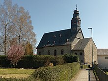
The patron saint of the Catholic parish is St. Catherine . The church is also consecrated to her.
In 1996 the Ransel Country Museum was opened. It would like to contribute to the preservation of rural culture in the Rheingau. On an area of 1.5 hectares, more than 600 hand tools and agricultural machines as well as a restaurant, a bakery and a brewery can be visited.
Attractions
The former parish church of St. Catherine
See also the Ransel district - List of cultural monuments in Lorch (Rheingau)
Individual evidence
- ↑ Wiesbadener Tagblatt from June 16, 2015: "Ransel receives evaluation committee for state decision 'Our village has a future'"
- ^ Federal Statistical Office (ed.): Historical municipality directory for the Federal Republic of Germany. Name, border and key number changes in municipalities, counties and administrative districts from May 27, 1970 to December 31, 1982 . W. Kohlhammer GmbH, Stuttgart / Mainz 1983, ISBN 3-17-003263-1 , p. 376 .
- ^ Landmuseum Ransel Official website of the museum
Web links
- Ransel on the website of the city of Lorch
- "Ransel, Rheingau-Taunus-Kreis". Historical local dictionary for Hessen. In: Landesgeschichtliches Informationssystem Hessen (LAGIS).
- Literature about Ransel in the Hessian Bibliography
- Private website about Ransel
