Tiefenbach (Wisper)
| Tiefenbach | ||
|
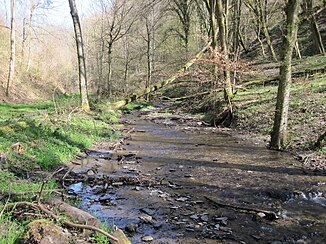
Tiefenbach between Sauerthal and Lorch |
||
| Data | ||
| Water code | EN : 2568 | |
| location |
Taunus
|
|
| River system | Rhine | |
| Drain over | Wisper → Rhine → North Sea | |
| source | between Weisel and Ransel , approx. 2 km north of Sauerthal 50 ° 6 ′ 51 ″ N , 7 ° 49 ′ 46 ″ E |
|
| Source height | approx. 340 m above sea level NN | |
| muzzle | at Lorch in the Wisper coordinates: 50 ° 3 '5 " N , 7 ° 49' 15" E 50 ° 3 '5 " N , 7 ° 49' 15" E |
|
| Mouth height | approx. 90 m above sea level NN | |
| Height difference | approx. 250 m
|
|
| Catchment area | 16.126 km² | |
| Communities | Sauerthal | |
The Tiefenbach is a right tributary of the Wisper .
course
The Tiefenbach begins its way as a border stream between the district of Weisel and the Kreuzwald in the east, an exclave of the district of Dörscheid . It flows in a north-south direction through a deeply wooded Taunus valley , in which Sauerthal is the only village. In this valley, slate mining was carried out in several pits , the pit water of which was drained over the Tiefenbach, for example from the Kreuzberg-Wilhelmsberg pit . Above the forest, the valley is flanked by Weisel to the west and Ransel to the east . The Tiefenbach flows into the Wisper about four kilometers from the Rhine on the outskirts of Lorch .
Castles
At the course of the brook there are several castles, including the Waldeck castle ruins and the Sauerburg , which served to secure the border between the Rheingau and the Electoral Palatinate that has been running here since the Middle Ages .
Individual evidence
- ↑ a b Topographic map 1: 25,000
- ↑ Map service for the implementation of the Water Framework Directive in Hesse
