
Weisel (Rhein-Lahn district)
| coat of arms | Germany map | |
|---|---|---|

|
Coordinates: 50 ° 7 ' N , 7 ° 48' E |
|
| Basic data | ||
| State : | Rhineland-Palatinate | |
| County : | Rhein-Lahn district | |
| Association municipality : | Loreley | |
| Height : | 395 m above sea level NHN | |
| Area : | 13.06 km 2 | |
| Residents: | 1039 (Dec. 31, 2019) | |
| Population density : | 80 inhabitants per km 2 | |
| Postal code : | 56348 | |
| Area code : | 06774 | |
| License plate : | EMS, DIZ, GOH | |
| Community key : | 07 1 41 136 | |
| Association administration address: | Dolkstrasse 3 56346 St. Goarshausen |
|
| Website : | ||
| Local Mayor : | Peter Schmelzeisen | |
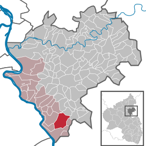
| Location of the local community Weisel in the Rhein-Lahn district | ||
  |
||

.jpg)
Weisel is a municipality in the Rhein-Lahn district in Rhineland-Palatinate . It belongs to the Verbandsgemeinde Loreley , which has its administrative headquarters in St. Goarshausen .
geography
Geographical location
Weisel is on the Taunus heights , 400 m above sea level. NHN on a ridge that divides here, aims in a south-westerly direction via the neighboring village Dörscheid on the shortest route to the Middle Rhine Valley and in a north-westerly direction via the neighboring village Bornich to the Loreley plateau , which is five kilometers away. The area of Weisel belongs to the natural subunit Middle Rhine Taunus .
The ridge around Weisel is not forested and is mainly used for agriculture. The community forest is mostly in the north and northeast across the Harbach . In the north, the district is bounded by the Krummebach , a left tributary of the Forstbach , which flows into the Rhine at Sankt Goarshausen . In the southeast it extends to the former Glückauf slate mine in the upper Tiefenbachtal , which leads via Sauerthal to Wisper near Lorch (Rheingau) . In the south, the district ends, two kilometers from the Rhine , in the upper Blüchertal and also includes the Victoriastollen , which was used for slate mining, and the Heiligenberg .
The lowest layers of the municipality are in the south the Holzbachtal below the Victoria tunnel at 280 m above sea level. NHN and in the north the Forstbachtal in front of the Heppenhofmühle at 290 m above sea level. NHN . The highest point is in the east at 444 m above sea level. NHN where the community forest covers the Weiseler ridge.
Living spaces
Weisel also includes the Brühlhof, Grube Glückauf, Harbacher-Mühle, Jagdhaus, Magdalenenhof, Viktoriastollen (partially), Buchenau and Kreuzhöherhof residential areas .
Neighboring communities
Bornich , the Loreley community , is two kilometers to the west, Dörscheid and Kaub are both three kilometers away in the southwest, and Rettershain is three kilometers further to the northeast. With Lipporn in the northeast and Reitzenhain in the north, both about four kilometers away, there are short shared borders, but no direct road connection.
climate
“The place is a bit wintry and rough, but fairly healthy”, is how a convent protocol of the Reformed Bacharach class in 1607 describes the village of Weisel. ( Lit .: Municipality of Weisel (Ed.) Et al. , 1985)
history
On the border of the former Kurpfälzer area was formerly the castle Heppe booklet . The ancestors of this knightly family , which existed from 1123 to 1453, were the lords of Wisilo , who may have given the village of Weisel its name.
Weisel was first mentioned in 1275. Together with Dörscheid and Kaub it belonged to the Lords of Falkenstein until Ludwig II of the Palatinate bought it from them in 1277 and 1289. Weisel received on 23 March 1324 together with Caub by Emperor Louis the Bayer the town charter . In 1372, Elector Ruprecht I burned the village down in a feud.
The plague raging in 1613 wiped out almost the entire village. The Thirty Years War then brought great suffering and devastation to the region. From 1620 to 1649 the owners changed several times. Spain , Sweden and France took over. In 1650 37 families lived here. The village consisted of 31 houses and 23 barns. The number of livestock was 1 horse, 61 oxen and 45 cows.
In the second half of the 19th century, terrible fires ravaged the village. In 1810, 63 buildings (half of the village) were reduced to rubble during such a disaster.
Another setback for the population was Blücher's crossing of the Rhine at the beginning of 1814, when he was chasing Napoleon after the Battle of Leipzig . Approx. 50,000 soldiers marched through Weisel with 15,000 horses plundering. The damage was estimated at 30,000 guilders . The three-day siege not only caused material damage, but Blucher's troops also brought in typhus , from which over 70 people died in the following time. From 1806 to 1866 Weisel belonged to the Duchy of Nassau and the Office of St. Goarshausen . In 1838 there were 128 houses and 200 inhabitants in the village. After the Prussian annexation of the Duchy of Nassau, Weisel came to the new province of Hessen-Nassau .
The two world wars also brought great suffering to Weisel. Many buildings were destroyed by bombs and grenades . 98 villagers lost their lives - 17 remained missing. On March 26, 1945, the first American troops arrived at around 4 p.m., and the place was completely taken on March 27. After the American occupation towards the end of the Second World War , Weisel then belonged to the French zone . Supply difficulties, housing shortages and the accommodation of numerous refugees from the eastern regions presented the population with major problems. In 1946 Weisel came to the then newly formed state of Rhineland-Palatinate through the ordinance of the French military government .
Since 1972 Weisel has been a member of the Loreley community , which has its administrative headquarters in St. Goarshausen .
politics
Municipal council
The municipal council in Weisel consists of 16 council members, who were elected in the local elections on May 26, 2019 in a majority vote, and the honorary local mayor as chairman. In the previous election, too, the council members were elected by majority vote. In the 2009 election, however, the council members were elected in personalized proportional representation because several nominations were submitted.
The distribution of seats in the municipal council:
| choice | SPD | CDU | FWG | total |
|---|---|---|---|---|
| 2019 | by majority vote | 16 seats | ||
| 2014 | by majority vote | 16 seats | ||
| 2009 | 8th | 4th | 4th | 16 seats |
| 2004 | by majority vote | 16 seats | ||
mayor
The local mayor of Weisel is Peter Schmelzeisen. No candidate ran for the direct election on May 26, 2019. Schmelzeisen was elected by the municipal council in the constituent meeting on June 24, 2019 and is thus the successor to Ottmar Kappus (SPD), who did not run again after 16 years in office.
coat of arms
|
|
The coat of arms of the community of Weisel shows a silver St. Andrew's cross on a blue background. |
| Justification of the coat of arms: The St. Andrew's cross is the symbol of the church patron St. Andreas and indicates the connection to the Bacharach church, formerly part of the St. Andreas monastery in Cologne . The colors silver and blue stem from the more than 500 years of belonging to the Electoral Palatinate . The current coat of arms of the municipality was awarded on August 18, 1937 by the President of the Province of Hessen-Nassau . |
Culture and sights
On the heavily wooded Taunus heights around Weisel, you can hike through the meadows and forests, and there are also a large number of hiking trails . The reconstruction of a Roman tumulus (Tumulus) from the 2nd century can be visited. The ground monument of the former Schanze Weisel fortification is located outside the village .
Museums
The motorcycle museum and the “small fire brigade museum” await fans of technology from the old days.
music
Several associations deal with music in the village.
There is the Evangelical Trumpet Choir Weisel, the Spielmannszug Weisel, the men 's choir and the women's choir . Furthermore, the a cappella group “The Singing Firefighters” has made a name for itself beyond the borders of Weisel .
Buildings
.jpg)

In terms of architecture, the town hall made of red bricks , the Protestant St. Andrew's Church, the Catholic chapel and the half-timbered buildings in the town center are particularly striking . Typical are the facades clad with slate and the roofs covered with slate.
See also: List of cultural monuments in Weisel
Natural monuments
The landmark of the community was the "old lime tree", a centuries-old linden tree , also called Lennebaam in Weisel . On July 27, 2005, a storm hit Weisel in the evening, which the linden tree did not survive. There is only a 2 meter high stump of the once 40 meter high tree.
See also: List of natural monuments in Weisel
Sports
The gymnastics club Weisel is the club with the largest number of members in Weisel. A variety of different sports are offered. The gymnastics club has a successful athletics department and a large fistball department with a men's team that plays in the fistball national league. In 2012, TV Weisel hosted the German field fistball championships for men and women .
Regular events
Two big festivals take place every year: the Weiseler Markt (last weekend in May) and the Oktoberkerb (third weekend in October).
Economy and Infrastructure

Until a few years ago, people lived here from agriculture and slate mining .
Roofing slate has been mined in Weisel since the 19th century, initially in open-cast mining and later also underground . The deposits of the Kauber Zug were dismantled from the Eckert mine (later the Glückauf mine ) until May 30, 1959 and the Kreuzberg-Wilhelmsberg mine until November 28, 1980. When the Kreuzberg mine was closed , the last slate mine on the Middle Rhine was closed.
The forestry in the community forest is an important source of income for the community.
traffic
Weisel can be reached from three directions via country roads. The L 339 leads from the southwest, starting from the federal highway 42 , from the Rhine through Kaub and the Blüchertal to Weisel and over the ridge further east to the L 337, which connects via Rettershain to Nastätten in the north and via Ransel to Lorch in the south . Furthermore, the L 338 from Weisel offers a connection to the northwest via Bornich to the Loreley and to Sankt Goarshausen . Finally, Dörscheid can be reached in the southwest via the K 99. The next train station is Kaub train station on the right bank of the Rhine .
Established businesses
Several companies are active in the forest technology and wood processing sectors. In addition to larger companies in the field of mechanical engineering and electrical engineering , whose products and developments are also of international importance, there are also smaller craft businesses in Weisel, including roofers , construction companies and painters . Several businesses, bakers and butchers provide basic supplies for the residents. There are also several offers in the field of gastronomy .
Public facilities
The community library offers all citizens of Weisel and the region around 2000 books, audio, video and data media, as well as magazines, to borrow. The library is located in the town hall.
Personalities
- Christian Kappus , secondary school teacher, linguist, honorary senator of the University of Marburg (1882–1945)
- Wilhelm Schmelzeisen (1909–1944), teacher, genealogist
- Karl Dienst (1930–2014), senior church councilor, church historian
- Margret Drees born Knecht (* 1937), writer, grew up in Weisel
- Hiltraud Strunk b. Schmelzeisen (* 1938), linguist, grew up in Weisel
- Helmut Schmelzeisen, surgeon (* 1940), pioneer of endoprosthetics in Germany, grew up in Weisel
- Günter Kern (* 1956), District Administrator, State Secretary
- Margit Göttert, sociologist, local researcher
- Ramona Kappus (* 1992), Middle Rhine Wine Queen 2011/12
literature
- Renate Knecht, Hermann Knecht, Theo Bernhard: Weisel a historical image documentation . Ed .: Municipality of Weisel. Weisel municipality (self-published), Weisel 1985.
- Theo Dillenberger: "The war was hell for everyone who had to experience it ..." The emergency landing of an American B17 bomber in Weisel in 1945. In: Research group Weiseler Geschichte (Ed.): Weiseler Geschichte (n) . tape 1 . Research group Weisel History (self-published), Weisel 2008.
- "Hoschde, can do it, do it" . Weisel dialect, songs and poems. In: Research group Weiseler Geschichte (Hrsg.): Weiseler Geschichte (n) . tape 2 . Research group Weiseler Geschichte (self-published), Weisel 2009 (with audio CD).
- Margit Göttert, Renate Knecht: The village of Weisel. History of the houses and their owners from the 17th to the middle of the 20th century . With 10 maps and 1094 illustrations. (= Research group Weiseler Geschichte [Ed.]: Weiseler Geschichte (n) . Volume 3 ). Self-published, Weisel 2012.
Web links
- Website of the local community of Weisel
- Local community Weisel on the website of the Verbandsgemeinde Loreley
- Website of the research group Weisel history (s)
- Historical information about Weisel at regionalgeschichte.net
Individual evidence
- ↑ State Statistical Office of Rhineland-Palatinate - population status 2019, districts, communities, association communities ( help on this ).
- ↑ Federal Agency for Nature Conservation: Landscape profile 30403 Middle Rhine Taunus ( page no longer available , search in web archives ) Info: The link was automatically marked as defective. Please check the link according to the instructions and then remove this notice.
- ↑ a b c d Topographic map 1: 25,000
- ↑ State Statistical Office Rhineland-Palatinate (ed.): Official directory of the municipalities and parts of the municipality. Status: January 2018 [ Version 2020 is available. ] . S. 46 (PDF; 2.2 MB).
- ↑ Stefan Michels: Sturm am Mittelrhein The German fights for withdrawal in the Vorderhunsrück and the Rhine-Mosel triangle as well as the end of the war in the Rhein-Lahn district in March 1945 . 1st edition. Helios Verlag, Aachen 2013, ISBN 978-3-86933-090-7 , p. 196-197 .
- ^ The Regional Returning Officer Rhineland-Palatinate: City Council Election 2019 Weisel. Retrieved November 2, 2019 .
- ^ The Regional Returning Officer Rhineland-Palatinate: Municipal elections 2014, city and municipal council elections
- ^ The State Returning Officer Rhineland-Palatinate: direct elections 2019. see Loreley, Verbandsgemeinde, 20th line of results. Retrieved November 2, 2019 .
- ↑ Information from the Loreley community - Official announcements: Honoring former council members. Edition 35/2019. Linus Wittich Medien GmbH, accessed on November 2, 2019 .
- ↑ Horst Fehr: A tumulus of the 2nd century in the district of Weisel, Rhein-Lahn-Kreis. In: Archeology in Germany. 8, 4, 1992, pp. 52-53
- ↑ Weiseler History Research Group Weiseler History (s)
- ↑ Weisel history: Dr. phil. Wilhelm Schmelzeisen
- ^ Badische Zeitung of June 11, 2010: The hip specialist celebrates. Professor Helmut Schmelzeisen is 70 years old today.

Allendorf | Altendiez | Arzbach | Attenhausen | Auel | Aull | Bad Ems | Balduinstein | Becheln | Mountain | Berghausen | Berndroth | Bettendorf | Biebrich | Birlenbach | Bogel | Bornich | Braubach | Bremberg | Book | Burgschwalbach | Charlottenberg | Cramberg | Dachsenhausen | Dahlheim | Dausenau | Dessighofen | Dienethal | Diethardt | Diez | Dörnberg | Dornholzhausen | Dörscheid | Dörsdorf | Ebertshausen | Honor | Eisighofen | Endlichhofen | Eppenrod | Ergeshausen | Eschbach | Fachbach | Filsen | Flat | Fruit | Geilnau | Geisig | Gemmerich | Gückingen | Gutenacker | Hahnstätten | Hainau | Hambach | Heistenbach | Herald | Himmighofen | Hirschberg | Holzappel | Holzhausen an der Haide | Holzheim | Hömberg | Horhausen | Hunzel | Isselbach | Kaltenholzhausen | Kamp-Bornhofen | Kasdorf | Katzenelnbogen | Kaub | Kehlbach | Kemmenau | Kestert | Klingelbach | Kördorf | Lahnstein | Langenscheid | Laurenburg | Lautert | Liiffer | Lipporn | Lohrheim | Lollschied | Lykershausen | Marienfels | Miehlen | Mielle | Misselberg | Mittelfischbach | Mudershausen | Nassau | Nasta | Netzbach | Niederbachheim | Niederneisen | Niedertiefenbach | Niederwallmenach | Never | Nochern | Oberbachheim | Oberfischbach | Oberneisen | Obernhof | Obertiefenbach | Oberwallmenach | Oberwies | Oelsberg | Osterspai | Patersberg | Pohl | Prath | Reckenroth | Reichenberg | Reitzenhain | Rescue Grove | Rescues | Roth | Ruppertshofen | Sankt Goarshausen | Sauerthal | Scheidt | Schiesheim | Schönborn | Schweighausen | Seelbach | Singhofen | Steinsberg | Strüth | Sulzbach | Wasenbach | Weidenbach | Weinähr | Weisel | World destruction | Weyer | Winches | Winter advertising | Room difference