Wispertaunus
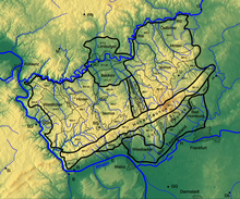
The Wispertaunus is a natural sub-unit of the western Hintertaunus with the division number 304.0. It lies between the Bacharacher Tal ( Upper Middle Rhine Valley ) in the west, the Middle Rhine Taunus and the Zorner plateau in the north, the Western Aartaunus in the east and the High Taunus in the south.

geography
The largest part of the Wispertaunus belongs to the Wisper valley system . The Wispertaunus has the landscape type of a pure forest landscape, which is deeply divided and only offers space for small village settlements on a few mountain ridges, especially above the northern right side valleys. Here are from west to east: Ransel , Wollmigart , Espenschied , Dickschied , Hilgenroth , Nauroth , Springen and Wisper . Only Presberg is located at a similar altitude above the southern left side valleys . The number of valley settlements is much lower. In the northwest, Sauerthal is located in the deep and narrow cut of the Tiefenbach , less because of its geographical advantages than because of its historical border location in an area of once valuable slate pits . There are also three valley settlements in the southeast: Niedergladbach , Obergladbach and Fischbach . The narrow valley floor of the Wisper itself only offers space for a single small village, for Geroldstein .
Natural location
- 304 Western Hintertaunus
- 304.0 Wispertaunus (145.05 km²)
fauna and Flora
In the Wispertaunus there are large contiguous forest areas such as the hinterland forest , which make this natural area particularly worthy of protection. More than a third of the area of the Wispertaunus is designated as a FFH area. Between the confluence of the Ernstbach and the Laukenmühle lies the Wispertal natural forest reserve of 21 hectares .
Individual evidence
-
↑ Environmental Atlas Hessen of the Hessian State Office for Environment and Geology: The natural areas of Hesse and their main units:
Map and description of the Taunus - Attention: Web links without return - ↑ Map service and description of the landscape "Wispertaunus" of the Rhineland-Palatinate nature conservation administration
- ↑ Map ( Taunus & Gießen-Koblenzer Lahntal ) and legend ( Taunus ) - attention: web links without return! - Environmental Atlas Hessen of the Hessian State Office for Environment and Geology: The natural areas of Hesse and their main units
- ↑ Landscape profile ( memento from July 19, 2012 in the web archive archive.today )
- ↑ Profile of the total reserve Wispertal
