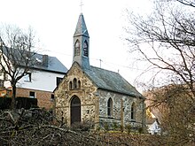
Geroldstein
|
Geroldstein
municipality Heidenrod
Coordinates: 50 ° 6 ′ 27 ″ N , 7 ° 56 ′ 19 ″ E
|
|
|---|---|
| Height : | 207 m above sea level NHN |
| Residents : | 89 (Feb 11, 2014) |
| Incorporation : | 1843 |
| Incorporated into: | Dickschied-Geroldstein |
| Postal code : | 65321 |
| Area code : | 06775 |
Geroldstein is a district of the community Heidenrod on the Wisper in the Rheingau-Taunus district in southern Hesse .
history
The place has changed its name several times over the centuries. On documents he is referred to as Girstein, Geritstein, Geroltsein, Gernstein and Gerhardtstein. The name presumably comes from a knight Gerhardt , who lived around 1170, from the family of the Counts of Katzenelnbogen , who had the lower castle built. From then on he called himself "von Gerhardtstein" and his successor Philipp built the larger upper castle complex above the ancestral castle in 1386 .
In 1843 Dickschied and Geroldstein merged to form the Dickschied-Geroldstein community . For the year 1846, Johann Philipp Dönges is named as the joint mayor.
A church was only built in 1899.
As Dickenschied-Geroldstein on 31 December 1971, ahead of the municipal reform in Hesse with another 15 municipalities on a voluntary basis to the municipality Heidenrod merged , became a separate for each of the two districts local district with town council erected. The local district of Geroldstein is limited to corridor 8 of the Dickschied-Geroldstein district and corridor 9 to the field properties in the valley.
Historical place names
In documents that have been preserved, Geroldstein was mentioned under the following names (the year it was mentioned in brackets): Gerhartstein, (around 1200); Gerhardesstein, (1262); Gerartstein, (1321); Gerstein, (around 1585); Gierstein, (1626); Gerolstein, (1629)
Economic history
In addition to agriculture , in the Middle Ages the people from Geroldstein did forestry as well as mills and fish farming due to the nearby forest and the stream. From 1590, forest forges and iron smelters are also known, which was due to the charcoal extraction by charcoal burners . Slate mining was carried out in Geroldstein until 1900, as can be seen in a number of slate tunnels. Some of the simple houses from the early 19th century still have a facade made of local slate.
Worth seeing
- Geroldstein Castle (Gerhartstein, Gerolstein)
- Haneck Castle
literature
- Dagmar Söder: Cultural monuments in Hessen. Rheingau-Taunus-Kreis Vol. 2, Altkreis Untertaunus. Published by the State Office for Monument Preservation Hessen , Theiss, Stuttgart 2003, ISBN 3-8062-1649-5 , pp. 184f. ( Monument topography Federal Republic of Germany ).
- Literature on Geroldstein in the Hessian Bibliography
Web links
- Geroldstein district on the website of the municipality of Heidenrod.
- Geroldstein. Local history, pictures. In: www.heimatverein-heidenrod.de. Heimatverein Heidenrod e. V.
- Geroldstein, Rheingau-Taunus-Kreis. Historical local dictionary for Hessen. In: Landesgeschichtliches Informationssystem Hessen (LAGIS).
Individual evidence
- ↑ Districts of the municipality of Heidenrod, population HW , accessed in April 2016
- ^ State and address manual of the Duchy of Nassau for the year 1847 Page 78: Dickschied with Geroldstein in the Langen-Schwalbach office
- ^ Federal Statistical Office (ed.): Historical municipality directory for the Federal Republic of Germany. Name, border and key number changes in municipalities, counties and administrative districts from May 27, 1970 to December 31, 1982 . W. Kohlhammer, Stuttgart / Mainz 1983, ISBN 3-17-003263-1 , p. 378 .
- ↑ main statute. (PDF; 100 kB) § 5. In: Website. Heidenrod municipality, accessed February 2019 .
- ^ Geroldstein, Rheingau-Taunus-Kreis. Historical local dictionary for Hessen. (As of March 28, 2014). In: Landesgeschichtliches Informationssystem Hessen (LAGIS).


