Western Aartaunus
The Western Aartaunus is a natural sub-unit of the Western Hintertaunus (main unit 304) with the division number 304.1.

location
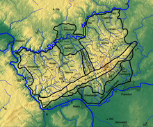
The western Aartaunus is bounded in the south by the western Hohe Taunus ( Wiesbadener Hochtaunus ), to the east by the Aartal , to the west by the Wispertaunus and to the north by the Katzenelnbogen plateau .
Natural location
In the southeast of the western Hintertaunus the landscape consists of the western Aartaunus, the high Kemeler ridge (500 to 550 m ). This western high block, running from southeast to northwest, welds itself to the Taunus main ridge in the area of the Hohe Wurzel ( 617.9 m ). The morphological connection with the Taunus ridge is partly interrupted by the intramontane high basin of Taunusstein (Aar source area). This lowering has set good economic and settlement-geographic impulses. In this " intermediate mountain hollow " (350 to 400 m ) loess was deposited during the Ice Age , which has always favored agriculture. Today the districts of Taunusstein are concentrated here. The Bäderstraße ( B 260 ) runs along the ridge of this high block . The Taunus Wunderland is located in the south-eastern root area . To the northwest rises the Neuzehntberg (approx. 530 m ) and in the middle of the Hochscholle the eponymous place Kemel rises at an altitude of 517 m . The Kemeler Ridge reaches its highest point in the Mappershainer Kopf ( 548 m ). In a north-westerly direction from the Mappershainer head, the rock stern rises ( 537.2 m ). Due to the somewhat lower elevation compared to the Feldberg-Langhals-Pferdskopf-Scholle in the Eastern Hintertaunus , the Kemeler Ridge runs more in the plateaus (350 to 450 m ) of the Western Hintertaunus . At Laufenselden , in Schönauer Küppel ( 459 m ), in the Grauen Kopf even another 543.4 m are reached before the Hochscholle after Holzhausen an der Haide drops to a height of only 390 m .

The Hochscholle in the eastern Hintertaunus is the Feldberg-Langhals-Pferdskopf-Scholle , with the section number 302.6 (Pferdskopf-Taunus), at heights of 600 to 700 m in the root area of the Großer Feldberg ( 879 m ) and the Kleinen Feldberg ( 825.2 m ) . To the northwest, the Hochscholle falls in steps to a height of 450 to 550 m . This eastern Hochscholle starts in the most prominent mountain knot (over 800 m ) in the Feldberg-Taunus ridge . In addition to their geological and morphological uniformity, both high clods have one more thing in common: They are each divided lengthways by a stream valley that was created before the high clods were raised. The Kemeler Ridge is divided by the longitudinal furrow of the Aar , which, however, is slightly shifted to the east. The Feldberg-Langhals-Pferdskopf-Scholle is divided lengthways by the Weil, which runs from the Kleiner Feldberg to Weilburg . Both creeks, Aar and Weil, have dug themselves deep into the high clods, especially since they had enough time to keep their old courses on the rump surfaces when slowly climbing out of the Rhenish slate mountains and to relocate them deeper in the high clods.
- 304 Western Hintertaunus
- 304.1 Western Aartaunus (82.66 km²)
Mountains and elevations
The highest mountains and elevations of the Western Aartaunus include - sorted by height in meters (m) above mean sea level (NHN):
- Mappershainer head (548.0 m)
- Gray head (543.4 m)
- Rock tail (537.2 m)
- Neunzehntberg (approx. 530 m)
- Bienkopf (521.9 m)
Kemeler Heath

The Kemeler Heide lies on the middle to northern Kemeler Ridge , with a forest cover of more than 60%. Until the 19th century, a large part of the landscape was still used as heather and was later reforested. It stretches from the southern Kemel to the northern drop in height of the Hochscholle at Grauen Kopf before Holzhausen an der Haide.
Individual evidence
- ↑ Eugen Ernst: Der Taunus - Ein L (i) ebensworth Mittelgebirge , Societäts-Verlag, 2009, p. 21 u. 34
- ↑ Map ( Taunus & Gießen-Koblenzer Lahntal ) and legend ( Taunus ) - attention: web links without return! - Environmental Atlas Hessen of the Hessian State Office for Environment and Geology: The natural areas of Hesse and their main units
- ↑ Map of the Western Aartaunus . In: Landesgeschichtliches Informationssystem Hessen (LAGIS).
- ↑ Stolz, C., Böhnke, S., Grunert, J. (2012): Reconstructing 2500 years of land use history on the Kemel Heath (Kemeler Heide), southern Rhenish Massif, Germany ( Memento of the original from March 5, 2016 in Internet Archive ) Info: The archive link was inserted automatically and has not yet been checked. Please check the original and archive link according to the instructions and then remove this notice. - E&G Quaternary Science Journal, Volume 61, Number 2: pp. 173-187; English. (PDF; 3 MB)
swell
- Federal Agency for Nature Conservation:
- Map services of the Federal Agency for Nature Conservation ( information )
- Landscape profile: Eastern Hintertaunus
- Environmental Atlas Hessen:
- map
- Description (natural area 304.1)
Web links
- Summit in the Taunus for dominance and prominence , on thehighrisepages.de
