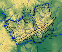
Horse head Taunus
The horse head Taunus is a natural sub-unit of the Eastern Hintertaunus (main unit 302) with the division number 302.6.

location
The Pferdskopf-Taunus is bounded to the south by the eastern Hohen Taunus ( Feldberg Taunskamm ), to the east by the Usinger Basin and to the north by the course of the Weiltal and the Hasselbacher Hintertaunus . To the west from the Steinfischbacher Hintertaunus , which marks the subsequent demolition to the deep Idsteiner Senke , the Goldenen Grund .
Natural location

In the southwest of the eastern Hintertaunus is the Hochscholle of the Pferdskopf-Taunus, the so-called Feldberg-Langhals-Pferdskopf-Scholle . This is a ridge running from southeast to northwest , and starts in the most prominent mountain node (over 800 m ). From the root area on the Taunushauptkamm , in the area of the Großer Feldberg ( 879 m ) and the Kleine Feldberg ( 825.2 m ) the Feldberg- Taunus ridge in the Hochtaunus , this high plaice from the Ems , Aubach and Weilquell areas is initially composed of mountain peaks of almost the same height , with heights between 600 and 700 m . The highest mountains in this area are the Weilsberg ( 700.7 m ), Dillenberg ( 682.4 m ), Sängelberg ( 665 m ) and Weisseberg ( 660.2 m ). The horse's head on the opposite side of the Weiltal is 662.6 m high. In contrast, the Klingenberg ( 595.9 m ), the Great Oak Forest ( 633.2 m ) and the Langhals ( 573.5 m ) on the eastern side of the Hochscholle have already lost height. The Hühnerberg ( 636 m ), the Bremer Berg ( 618.9 m ), the Judenkopf ( 613.8 m ) and the Pfaffenkopf ( 586.9 m ) are the notable elevations on the western side of the Hochscholle. To the northwest, the Feldberg-Langhals-Pferdskopf-Scholle descends in steps to heights between 450 and 550 m . The significant elevations such as Wolfsküppel ( 545.1 m ), Sommberg ( 460.8 m ), Stückelberg ( 509.7 m ), Kuhbett ( 525.6 m ), Suterkopf ( 461.8 m ) and Koberg ( 460.5 m) ) gradually descend to the level of the plateaus (350 to 450 m ). From Emmershausen onwards , the heights of the clods blur almost completely into the plateaus of the eastern Hintertaunus . Towards the Pferdskopf-Taunus, the landscape to the east of the Idsteiner Senke rises in two stages and even exceeds the Rheingau mountains in height. The approximately 5 to 10 kilometers wide and well-structured Hochscholle is bounded in the west by the Steinfischbacher Hintertaunus and the western Emsbach Fault, which marks the break-off to the Goldener Grund .

The Hochscholle in the western Hintertaunus is the Kemeler Ridge (500 to 550 m ) with the section number 304.1 ( Westlicher Aartaunus ). Due to its somewhat lower elevation, this western high block runs rather in the plateaus of the western Hintertaunus. In addition to their geological and morphological uniformity, both high clods have one more thing in common: They are each divided lengthways by a stream valley that was created before the high clods were raised. The Feldberg-Langhals-Pferdskopf-Scholle is divided lengthways by the Weil, which runs from the Kleiner Feldberg to Weilburg . The Kemeler Ridge is divided by the longitudinal furrow of the Aar , which, however, is slightly shifted to the east. Both brooks Weil and Aar have dug their way deep into the high clods, especially since they had enough time to keep their old courses on the rump surfaces when slowly climbing out of the Rhenish slate mountains and to relocate them deeper in the high clods.
- 302 Eastern Hintertaunus
- 302.6 Pferdskopf-Taunus (81.47 km²)
Mountains and elevations
The highest mountains and elevations of the Pferdskopf-Taunus include - sorted by height in meters (m) above mean sea level (NHN):
- Weilsberg (700.7 m)
- Dillenberg (682.4 m)
- Sängelberg (665.0 m)
- Horse head (662.6 m)
- Weisseberg (660.2 m)
Riedelbach Heath
On the Feldberg-Langhals-Pferdskopf-Scholle there were a number of heathland landscapes in earlier years , some of which no longer exist due to the intensive forest management and high-altitude agriculture . The Riedel Bacher Heath , east of racing street , is one among nature conservation standing heathland, dealing with a very large junipers received.
Individual evidence
- ↑ a b Eugen Ernst: Der Taunus - Ein L (i) ebenswerte Mittelgebirge , Societäts-Verlag, 2009, p. 21 u. 34
- ↑ Map ( Taunus & Gießen-Koblenzer Lahntal ) and legend ( Taunus ) - attention: web links without return! - Environmental Atlas Hessen of the Hessian State Office for Environment and Geology: The natural areas of Hesse and their main units
- ↑ Map of the horse head Taunus . In: Landesgeschichtliches Informationssystem Hessen (LAGIS).
swell
- Federal Agency for Nature Conservation:
- Map services of the Federal Agency for Nature Conservation ( information )
- Landscape profile: Eastern Hintertaunus
- Environmental Atlas Hessen:
- map
- Description (natural area 302.0)
Web links
- Summit in the Taunus for dominance and prominence , on thehighrisepages.de