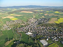
Golden reason
The Goldener Grund is a natural area (code 303.0) in the Taunus (main unit group 30) in Central Hesse and the northern part of the Idsteiner Senke (main unit 303), which connects the Limburg basin (311) with the main ridge of the Hohe Taunus (301) in the south and the Hintertaunus is divided into an east and a west part.
geography
The Goldene Grund spreads along the north-flowing Emsbach River for around 32 km² from the northern end of the Idsteiner Wald (303.3) near Walsdorf over the town of Bad Camberg to its district Oberselters . In the popular sense, the Goldener Grund follows the Emsbach a little further and the towns of Niederselters, Oberbruch, Niederbruch, Lindenholzhausen, Ennerich and Eschhofen are seen all the way to its confluence with the Lahn in the Limburg basin.
The golden reason is the natural sub-unit with the code number 303.0 within the Idsteiner Senke (main unit 303). To the north it opens up like a funnel to the Limburg Basin , which, as a tertiary basin , has a close genetic relationship with the Idsteiner Basin.
The old trade route Frankfurt - Cologne , which corresponds to today's Bundesstraße 8 , the Main-Lahn-Bahn and the Bundesautobahn 3 run through the Goldener Grund , all roughly parallel to each other and approximately in a north-south direction.
Naming
The name is derived from the loess soil that is particularly fertile in this area . In the Ice Age, the sedimentary rock was blown out of the unprotected soil by the poverty of vegetation by the wind and deposited again in protected places. Mineral springs can be found in the far north between Ober- and Niederselters .
history
In the Idsteiner Senke, elaborate landscape archeology has proven at least 66 so-called band - ceramic houses: they show how the first sedentary arable farmers lived in Hesse around 7,500 years ago.
Due to his missionary work and the foundation of the Walsdorf Monastery in the 12th century, the priest Gottfried von Beselich is also referred to in an old monastery chronicle as the "Apostle of the Golden Ground" .
Cities and towns in the Goldener Grund
Following the course of the river Emsbach from south to north, the following villages are located in the Goldener Grund:
- Golden reason natural area
- Walsdorf (City of Idstein)
- Würges (City of Bad Camberg)
- Bad Camberg
- Erbach (City of Bad Camberg)
- Oberselters (City of Bad Camberg)
- North of the popular Golden Ground in the Limburg Basin
Individual evidence
- ↑ Map ( Taunus & Gießen-Koblenzer Lahntal ) and legend ( Taunus ) - attention: web links without return! - Environmental Atlas Hessen of the Hessian State Office for Environment and Geology: The natural areas of Hesse and their main units .
- ↑ Christoph W. Martin: Gottfried von Beselich: Life and Work. Beselicher Schriften Nr. 11, 1999, ISSN 0934-036X , p. 4.
swell
- Federal Agency for Nature Conservation
- Environmental Atlas Hesse
- map
- Description (natural area 303.0)
literature
- Alexander Stahr, Birgit Bender: The Taunus - A journey through time. Stuttgart 2007, ISBN 978-3-510-65224-2 .
- Eugen Ernst: The Taunus - An L (i) worthwhile low mountain range. Frankfurt 2009, ISBN 978-3-7973-1146-7 .


