Emsbach
| Emsbach | ||
|
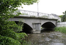
Emsbach in Würges |
||
| Data | ||
| Water code | DE : 25874 | |
| location |
Taunus
|
|
| River system | Rhine | |
| Drain over | Lahn → Rhine → North Sea | |
| source | between Glaskopf and the Kleiner Feldberg in the municipality of Glashütten 50 ° 13 ′ 5 ″ N , 8 ° 26 ′ 1 ″ E |
|
| Source height | 695 m above sea level NHN | |
| muzzle | near Eschhofen in the Lahn coordinates: 50 ° 23 '55 " N , 8 ° 5' 53" E 50 ° 23 '55 " N , 8 ° 5' 53" E |
|
| Mouth height | 110 m above sea level NHN | |
| Height difference | 585 m | |
| Bottom slope | 15 ‰ | |
| length | 39.1 km | |
| Catchment area | 321.8 km² | |
| Discharge A Eo : 321.8 km² at the mouth |
MNQ MQ Mq |
492 l / s 1.805 m³ / s 5.6 l / (s km²) |
| Left tributaries | Schlabach, Adenbach, Knallbach, Wörsbach | |
| Right tributaries | Reichenbach, Fischbach , Dombach, Eisenbach, Laubusbach | |
| Small towns | Bad Camberg | |
The Emsbach (also called Ems ) in the Taunus is a 39.1 km long, left-hand or southern tributary of the Lahn ; it flows through the districts of Hochtaunus , Rheingau-Taunus and Limburg-Weilburg .
geography
course
The Emsbach rises in the Hohe Taunus below the Kleiner Feldberg in the area of the municipality of Glashütten . First of all, the river flows through the district of Oberems (there through the nature reserve Oberes Emsbachtal ), over the border to the Rheingau-Taunus district and there through Waldems with the districts of Wüstems , Niederems and Esch . The Reichenbach flows between Wüst- and Niederems, and the Fischbach between Esch and Walsdorf .
In its further course the Emsbach flows past the Idsteiner district Walsdorf, where the Knallbach flows. The Goldene Grund is passed through the Bad Camberg districts Würges , Bad Camberg, Erbach and Oberselters . The Angelbach flows into Würges and the Dombach into Erbach . The Emsbach continues to flow through the Niederselters , Oberbruch and Niederbruch . The Eisenbach flows between the Ober- and Niederselters, the Laubusbach in Oberbruch and the Wörsbach, the most important tributary of the Emsbach, in Niederbruch .
Finally it flows through Limburg - Lindenholzhausen and Runkel - Ennerich and flows into the Lahn north of Mühlen , on the opposite side of Dietkirchen .
Tributaries
- Hasselbach ( right ), 0.8 km
- Furtwiesbach ( right ), 1.3 km
- Reichenbach ( right ), 3.0 km
- Diersbach ( left ), 1.1 km
- Tiefenbach ( right ), 1.6 km
- Schlabach ( left ), 6.3 km
- Fischbach ( right ), 4.6 km
- Laubach ( right ), 2.7 km
- Knallbach ( left ), 7.4 km
- Brombach ( left ), 2.6 km
- Schwabach ( right ), 4.1 km
- Dombach ( right ), 9.1 km (with Dottenbach 11.1 km)
- Bächelgraben ( left ), 1.2 km
- Eisenbach ( right ), 8.9 km
- Mannbach ( right ), 1.8 miles
- Laubusbach ( right ), 14, km
- Wörsbach ( left ), 15 miles
- Sauerbornsgraben ( left ), 1.1 km
Individual evidence
- ↑ a b c d Topographic map 1: 25,000 and database WFD Hessen
- ↑ a b c Water map service of the Hessian Ministry for the Environment, Climate Protection, Agriculture and Consumer Protection ( information )
- ↑ a b c Designation according to the property map at the Hessenviewer
- ↑ Designation according to field names, GKZ 25874596
Web links
- Water profile and program of measures 25874.1 ( Memento from January 1, 2013 in the web archive archive.today ) ( Notes ) → Overview of all Hessian river systems (PDF, 1.7 MB) Emsbach
- Level when breaking down on the HLUG side
- Retention cadastre for the Emsbach river basin code number: 25874 (PDF file; 6.54 MB)
- Literature about Emsbach in the Hessian Bibliography

