
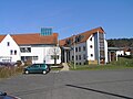
Esch (Waldems)
|
Esch
municipality Waldems
|
|
|---|---|
.png) |
|
| Height : | 250 (250–273) m above sea level NHN |
| Area : | 7.56 km² |
| Residents : | 1037 (Jan. 1, 2019) |
| Population density : | 137 inhabitants / km² |
| Incorporation : | August 1, 1972 |
| Postal code : | 65529 |
| Area code : | 06126 |
Esch is a district of the municipality of Waldems in the Rheingau-Taunus district in southern Hesse . The place is known as the gateway to the golden ground . The seat of the municipal administration is in Esch.
geography
The place lies in the Emsbach valley of the Hintertaunus and the nature park Rhein-Taunus .
history
Esch is an ancient settlement from the 6th century. The place was first mentioned in the interest register of the archive deacon of Dietkirchen with the place name Eschze .
The old carpenter's shop, a half-timbered building from 1686 , is well preserved .
On August 1, 1972, the previously independent municipality of Esch was merged with five other places to form the new municipality of Waldems.
Culture and sights
For the listed cultural monuments of the place see the list of cultural monuments in Esch .
Village community center and Catholic parish

The Protestant Church
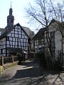
The Kirchgasse

The old carpenter's shop
.JPG)


traffic
Bundesstrasse 275 and Bundesstrasse 8 meet in the village . Due to the topography, building a bypass road is time- consuming. Due to the high volume of traffic, the citizens' initiative “Outside instead of in the middle” is committed to building a bypass road. In the current Federal Transport Infrastructure Plan from 2016, bypassing is an urgent requirement, i.e. H. classified with high priority. However, processing was initially postponed by the state of Hesse (so-called Al-Wazir list from May 2017), because due to the large number of requirement plan projects, only those projects with an advanced planning status can continue to be processed until 2021. The B8 bypass is currently being examined for those projects that were not taken into account in the Al-Wazir list of May 2017 and that could be included in the update of the list of the state of Hesse's requirement plan measures to be processed until 2025.
Personalities
- Philipp Reinhard Seybert (1790–1829), member of the Nassau state parliament from Esch
- Wilhelm Seybert (1820–1860), member of the Nassau state parliament from Esch
- Waldemar Vinz (1906–1986), German engineer born in Esch
Web links
- District Esch In: Website of the municipality of Waldems.
- Esch, Rheingau-Taunus-Kreis. Historical local dictionary for Hessen. In: Landesgeschichtliches Informationssystem Hessen (LAGIS).
- Literature about Esch in the Hessian Bibliography
Individual evidence
- ^ Esch, Rheingau-Taunus-Kreis. Historical local dictionary for Hessen. (As of October 16, 2018). In: Landesgeschichtliches Informationssystem Hessen (LAGIS).
- ↑ District Esch In: Website of the municipality Waldems, accessed on August 4, 2020.
- ↑ Law on the reorganization of the Obertaunus district and the district of Usingen (GVBl. II No. 330-18) of July 11, 1972 . In: The Hessian Minister of the Interior (ed.): Law and Ordinance Gazette for the State of Hesse . 1972 No. 17 , p. 227 , & 12 ( online at the information system of the Hessian state parliament [PDF; 1,2 MB ]).
- ^ Federal Statistical Office (ed.): Historical municipality directory for the Federal Republic of Germany. Name, border and key number changes in municipalities, counties and administrative districts from May 27, 1970 to December 31, 1982 . W. Kohlhammer GmbH, Stuttgart and Mainz 1983, ISBN 3-17-003263-1 , p. 378 .
- ↑ FAZ from May 20, 2010 ( page no longer available , search in web archives ) Info: The link was automatically marked as defective. Please check the link according to the instructions and then remove this notice.

Bermbach | Esch | Niederems with Reinborn | Reichenbach | Steinfischbach | Wüstems
Hamlet: threshing floor