
Reinborn
|
Reinborn
municipality Waldems
Coordinates: 50 ° 15 ′ 43 ″ N , 8 ° 21 ′ 27 ″ E
|
|
|---|---|
| Height : | 410 m above sea level NN |
| Postal code : | 65529 |
| Area code : | 06087 |

Reinborn is a settlement in the Niederems district in the municipality of Waldems in the Rheingau-Taunus district in southern Hesse .
Geographical location
Reinborn is located in the eastern Hintertaunus in the Rhine-Taunus nature park . In contrast to most of the villages in the Taunus , which are located in valleys, it is above the valley of the Lahn tributary Emsbach at the upper end of the Reinborner Grund at around 410 m above sea level. NN . To Niederems, where the district road 748 leads, it is 800 m to the south (as the crow flies ).
history
The place was first documented in 1274. Its name is derived from Rinnebronne , the source of an Emsbach tributary.
The district was incorporated into the municipality of Niederems in the 18th century .
On August 1, 1972, the previously independent municipality of Niederems was merged with five other places to form the new municipality of Waldems. Law on the reorganization of the Obertaunuskreis and the Usingen district (GVBl. II No. 330-18) of July 11, 1972 . In: The Hessian Minister of the Interior (ed.): Law and Ordinance Gazette for the State of Hesse . 1972 No. 17 , p. 227 , § 12 ( online at the information system of the Hessian state parliament [PDF; 1,2 MB ]).
Religions
The Reinborn Evangelical Church Community is associated with the Esch Church Community .
Culture and sights
Buildings
Three buildings of the settlement are under monument protection: The house Reinborn 9 (there are no street names, all houses in the village have numbers), the back house (Reinborn 11) and the barn of the property Reinborn 13.
Cultural monuments
For the listed cultural monuments of the place see the list of cultural monuments in Reinborn .
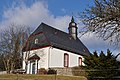
church

A church has been recorded in Reinborn since 1576. The Gothic or Romanesque chapel to the east outside the town was destroyed during the Thirty Years War . In its place, a hall church was built between 1722 and 1724 in the simple rural late baroque style.
The church is right next to the linden tree. In front of the church is the war memorial that commemorates the victims of the world wars. The village cemetery is behind the church.
In 2001, a meditation circuit was laid out for Francis of Assisi's Canticle of the Sun.
Natural monuments
- "1000 year old" linden tree
In the Middle Ages, the "1000-year-old" linden tree in front of the site probably had the function of a court linden tree and marked the place of the court of justice on the Ems . Today it is one of the most important living natural monuments in the Rhine-Taunus Nature Park and was placed under monument protection in 1928. The tree is deeply split. To save him, a central steel pillar was erected, which holds the fragments of the tree with a large number of steel cables. The trunk circumference was 14.29 m in 2015.

View of Reinborn (right) and Niederems from Windhain , to the left over Niederems the Idstein district of Wörsdorf can be seen .

Linde in Reinborn with the church in the background and the war memorial on the left

Linden tree

Plaque on the cemetery wall with local, church and linden history
church
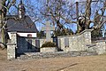
War memorial
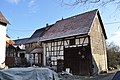
Reinborn 9

View of the Feldberg


Individual evidence
- ^ Federal Statistical Office (ed.): Historical municipality directory for the Federal Republic of Germany. Name, border and key number changes in municipalities, counties and administrative districts from May 27, 1970 to December 31, 1982 . W. Kohlhammer GmbH, Stuttgart and Mainz 1983, ISBN 3-17-003263-1 , p. 378 .
- ^ Reinborn in the directory of monumental oaks . Retrieved January 31, 2017
- ↑ “Ortslinde in Reinborn” in the tree register at www.baumkunde.de
Web links
- Niederems settlement on the Waldems website.
- Reinborn. Local history, information. In: www.niederems.de. Private website
- Reinborn, Rheingau-Taunus-Kreis. Historical local dictionary for Hessen. In: Landesgeschichtliches Informationssystem Hessen (LAGIS).

Bermbach | Esch | Niederems with Reinborn | Reichenbach | Steinfischbach | Wüstems
Hamlet: threshing floor