Windhain (Taunus)
| Wind grove | ||
|---|---|---|
|
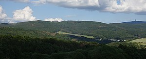
Windhain over Waldems- Wüstems seen from the Reinborn settlement , from the west. |
||
| height | 629.3 m above sea level NHN | |
| location | at Wüstems ; Rheingau-Taunus-Kreis and Hochtaunuskreis , Hesse ( Germany ) | |
| Mountains | Taunus | |
| Dominance | 1.74 km → Hühnerberg | |
| Notch height | 51 m ↓ Kittelhütte | |
| Coordinates | 50 ° 15 '26 " N , 8 ° 24' 22" E | |
|
|
||
The Windhain near the Waldems district of Wüstems is a mountain in the Taunus and at 629.3 m above sea level. NHN the highest in the Hessian Rheingau-Taunus district . It lies on the border from Waldems to Schmitten and Glashütten in the Hessian Hochtaunuskreis .
geography
location
The Windhain forms an elongated ridge on the border of the Rheingau-Taunus-Kreis to the Hochtaunuskreis. The district boundary also forms the boundary between the Taunus Nature Park in the east and the Rhine-Taunus in the west. The ridge rises with a peak in the Wüstems district of the Waldems community in the Rheingau-Taunus district; its east side slopes down to the district boundary in the valley floor of Seelenberg in the community of Schmitten in the Hochtaunuskreis and its south-east side towards Kittelhütte lies in the community of Glashütten with the mountainous district of Oberems .
Natural allocation
The Windhain belongs in the natural spatial main unit group Taunus (No. 30) and in the main unit Eastern Hintertaunus (302) to the subunit Horse Head Taunus (302.6). Its landscape slopes west to south-west into the Steinfischbacher Hintertaunus sub-unit (302.7).
Mountain height and summit location
The 629.3 m high Südkuppe Wind grove has the 4.5 km northwest of the highest Taunus Summit, Big Feldberg , situated main summit on the mountain. Its summit is in the Rheingau-Taunus district in the area of the Wüstems, which is 1.5 km west-southwest and just under 50 m northwest of the border with the Hochtaunus district. The eastern slope of this summit falls in the last-mentioned district in the valley of a small Weil tributary directly south of Seelenberg and the southeast slope in the municipality of Glashütten with the Oberems district located near the mountain. The southwestern outskirts of Seelenberg lies northeast of the main summit and is around 400 m away from the ridge of the ridge .
Almost 700 m from the south knoll is the 627.6 m high north knoll in the Rheingau-Taunus district ; the eastern slope of this knoll also falls into the Hochtaunuskreis and directly into the village of Seelenberg. The 584 m high side knoll of Heckenberg connects to the north .

Waters and water management
The Windhain is part of the ridge that forms the watershed between the Weil in the east and the Emsbach in the west, whose river systems both drain north to the Lahn . The small Emsbach tributary Hasselbach rises on the western slope of the southern crest and the Emsbach tributary Furtwiesbach rises on the northwest slope of the northern crest . The source of a small Weil tributary lies on the eastern slope of the southern summit and that of the small Saubach on the northeast slope of the northern summit , whose water also flows into the Weil through the Niedgesbach .
There is a water tank on each of the two crests , and the north crest also has a pumping station .
Trivia
In Seelenberg the name of the street Am Windhain is derived from the mountain name.
See also
Individual evidence
- ↑ a b Map services of the Federal Agency for Nature Conservation ( information )
- ↑ Brigitte Schwenzer: Geographical land survey: The natural space units on sheet 139 Frankfurt a. M. Federal Institute for Regional Studies, Bad Godesberg 1967. → Online map (PDF; 4.9 MB)
Web links
- Windhain , on peakbagger.com


