Waldems
| coat of arms | Germany map | |
|---|---|---|

|
Coordinates: 50 ° 15 ' N , 8 ° 19' E |
|
| Basic data | ||
| State : | Hesse | |
| Administrative region : | Darmstadt | |
| County : | Rheingau-Taunus district | |
| Height : | 252 m above sea level NHN | |
| Area : | 36.69 km 2 | |
| Residents: | 5140 (Dec. 31, 2019) | |
| Population density : | 140 inhabitants per km 2 | |
| Postal code : | 65529 | |
| Primaries : | 06126, 06087, 06082 | |
| License plate : | RÜD, SWA | |
| Community key : | 06 4 39 016 | |
| LOCODE : | DE WL3 | |
| Community structure: | 6 districts | |
| Address of the municipal administration: |
Schulgasse 2 65529 Waldems |
|
| Website : | ||
| Mayor : | Markus Hies ( CDU ) | |
| Location of the community of Waldems in the Rheingau-Taunus district | ||
Waldems is a municipality in the Rheingau-Taunus district in southern Hesse . The administrative seat is in the district of Esch .
geography
Geographical location
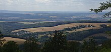
Waldems is located in the Taunus in a wooded area at the northwestern foot of the Feldberg massif at an altitude of 250 to 629.3 meters. With the Windhain , the municipality has the highest elevation in the Rheingau-Taunus district, 1 km east of the Wüstems district.
Neighboring communities
Waldems is the easternmost municipality in the Rheingau-Taunus district and borders in the northeast on the municipality Weilrod , in the east on the municipality Schmitten , in the southeast on the municipality Glashütten (all three in the Hochtaunuskreis ), in the south and west on the city of Idstein (Rheingau -Taunus-Kreis), and in the northwest to the city of Bad Camberg ( Limburg-Weilburg district ).
structure
The municipality consists of the six districts of Bermbach , Esch (seat of the municipal administration), Niederems (with Reinborn ), Reichenbach , Steinfischbach and Wüstems .
history
Although traces of settlement go back a long way, the current locations probably go back to clearing in Franconian times.
As the first of the suburbs, Bermbach was mentioned in 772 as Barenbach in a document from the Lorsch Codex . For many centuries this was a borderland, the Limes ran nearby and later the areas of influence of Kurmainz , Hesse and Nassau collided here. From 1276 to 1570 the village is linked to the noble family of the Lords of Bermbach. Bermbach is later mentioned in connection with the witch hunt and the legendary Schinderhannes (1801).
The district of Esch goes back to a settlement from the 6th century AD. The place Eschze is mentioned in a document in the interest register of the archive deacon of Dietkirchen. Esch is located at the crossroads of the ancient trade routes Frankfurt-Limburg-Cologne and the connecting road between the Rhine and Wetterau and therefore always had a high volume of traffic.
The history of Niederems can be traced back to the year 1274. Due to hunger, epidemics and wars, the population was always very low. The Thirty Years War , in particular, reduced the number of households considerably.
The traces of the settlement of Reichenbach can be traced back to pre-Christian times. Mention should be made of the Goldkessel tumulus and the ring wall castle . In 1428 the place is mentioned as Richinbach in the annals of Nassau-Idstein. In 1772 a fire destroyed the old town center, but it was quickly rebuilt. From 1604 to 1968 there was a school in Reichenbach .
In the vicinity of the Steinfischbach district, there are indications of early settlement in the form of the barrows skull and gold cauldron. The village is first mentioned in a document in 1156 under the name Vispach in a document from Archbishop Arnold von Mainz. Nearby, iron ore was mined and a quarry for millstones, road gravel, paving stones and boundary stones was operated.
Wüstems was mentioned as Wosten Emsse in 1435 in a note by Cuno von Reifenberg. The first syllable of the place name Wüst is probably derived from Wüstungen and indicates an abandoned settlement or agricultural area. The brook name Ems is derived from the Old High German Ohm . Both parts of the name suggest a settlement period that lasted more than 2000 years. This is also indicated by the Celtic ring wall at the nearby Taunus hill, Burg .
In 1806 the municipality came to the newly founded Duchy of Nassau and became Prussian with this in 1866 .
Territorial reform
As part of the municipal reform in Hesse , the previously independent municipalities Bermbach and ash from the were to August 1, 1972 by virtue of state law, Untertaunus circle and Niederems, Reichenbach, Steinfischbach and Wüstems from the district Usingen to today's large community Waldems in Untertaunus circle together . On January 1, 1977, the Untertaunuskreis merged into the newly founded Rheingau-Taunus-Kreis .
politics
Community representation
The local elections on March 6, 2016 produced the following results, compared to previous local elections:
| Parties and constituencies | % 2016 |
Seats 2016 |
% 2011 |
Seats 2011 |
% 2006 |
Seats 2006 |
% 2001 |
Seats 2001 |
||
|---|---|---|---|---|---|---|---|---|---|---|
| CDU | Christian Democratic Union of Germany | 35.3 | 10 | 34.0 | 9 | 29.2 | 8th | 26.7 | 8th | |
| SPD | Social Democratic Party of Germany | 29.1 | 8th | 30.7 | 8th | 34.3 | 9 | 37.3 | 12 | |
| GREEN | Alliance 90 / The Greens | 13.1 | 3 | 16.7 | 5 | 10.0 | 3 | 6.4 | 2 | |
| FWG | Free community of voters | 22.4 | 6th | 14.3 | 4th | 16.1 | 4th | 20.3 | 6th | |
| FDP / Waldems Citizens List | FDP / Waldems Citizens List | - | - | 4.2 | 1 | - | - | - | - | |
| FDP | Free Democratic Party | - | - | - | - | 4.0 | 1 | 3.1 | 1 | |
| UWK | Independent constituency | - | - | - | - | 6.3 | 2 | 6.2 | 2 | |
| total | 100.0 | 27 | 100.0 | 27 | 100.0 | 27 | 100.0 | 31 | ||
| Voter turnout in% | 59.0 | 56.8 | 52.2 | 58.0 | ||||||
mayor
Rudolf Dörr (FWG) was mayor from 1993 to 1999 and did not run again for health reasons. In the mayoral election, 37-year-old Dirk Foitzik prevailed against his SPD competitor with 52%. The following "marriage fraud" affair became known nationwide. Foitzik had stated in the election campaign that he was married. But he was only engaged (and the engagement didn't survive the affair). The FWG broke with him and the community board withdrew the certificate of introduction that had already been handed over to him. Dörr remained in office. At the beginning of October, the local council declared Foitzik's election to be invalid. In the last instance, the Hessian Administrative Court rejected the lawsuit . In the new elections in May 2000, Rudolf Dörr ran again and prevailed with 52% of the vote.
In March 2003 Werner Scherf (SPD) was elected as the new mayor. He was re-elected in December 2008 in the second ballot. In the mayoral election on November 30, 2014, Markus Hies (CDU) was elected mayor of Waldems with 68.0% of the vote. The turnout was 57.6%. The term of office began on June 1, 2015.
coat of arms
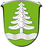
On April 4, 1976, the Hessian Minister of the Interior approved a coat of arms with the following blazon for the community of Waldems in the Untertaunuskreis : In green on a silver corrugated beam, a silver fir tree.
Partner communities
The community of Waldems maintains partnership relationships with
- Saint-Bonnet-en-Champsaur in the Hautes-Alpes department , France since 1982 and
- Szikszó in Hungary since 1997.
Cultural monuments
See: List of cultural monuments in Waldems
Economy and Infrastructure
Economic structure
In the past, the inhabitants of the villages lived from agriculture and forestry . In the second half of the 20th century, however, Waldems transformed into a residential community. Most employees earn their living in the Rhine-Main area , thanks to the good transport links .
The Ulisses Medien & Spiel Distributions GmbH is located in Waldems-Steinfischbach ; a publisher that sells the pen and paper role-playing game Das Schwarze Auge (DSA), among other things .
traffic
The municipality is well connected to the trunk road network with the Idstein junction of the federal motorway 3, eight kilometers away . In addition, the federal highways 8 and 275 run through the municipality and cross in Esch.
The closest train station is in Idstein on the Main-Lahn-Bahn . a. the RMV line 20.
literature
- Literature on Waldems in the Hessian Bibliography
- Literature by and about Waldems in the catalog of the German National Library
Web links
- Website of the municipality of Waldems
- Waldems, Rheingau-Taunus district. Historical local dictionary for Hessen. In: Landesgeschichtliches Informationssystem Hessen (LAGIS).
Individual evidence
- ↑ Hessian State Statistical Office: Population status on December 31, 2019 (districts and urban districts as well as municipalities, population figures based on the 2011 census) ( help ).
- ↑ Law on the reorganization of the Obertaunuskreis and the Usingen district (GVBl. II 30-18) of July 11, 1972 . In: The Hessian Minister of the Interior (ed.): Law and Ordinance Gazette for the State of Hesse . 1972 No. 17 , p. 227 , § 12 ( online at the information system of the Hessian state parliament [PDF; 1,2 MB ]).
- ^ Federal Statistical Office (ed.): Historical municipality directory for the Federal Republic of Germany. Name, border and key number changes in municipalities, counties and administrative districts from May 27, 1970 to December 31, 1982 . W. Kohlhammer GmbH, Stuttgart and Mainz 1983, ISBN 3-17-003263-1 , p. 378 .
- ^ Result of the municipal election on March 6, 2016. Hessian State Statistical Office, accessed in April 2016 .
- ^ Hessian State Statistical Office: Result of the municipal elections on March 27, 2011
- ^ Hessian State Statistical Office: Result of the municipal elections on March 26, 2006
- ↑ statistik.hessen.de
- ↑ z. B. Sedentary marriage swindler; in: Focus, No. 37, 1999
- ↑ Oliver M. Bock: Excitement about a "marriage fraud"; in: Yearbook '01 Rheingau-Taunus-Kreis, 2001, ISSN 1439-0779, p. 295.
- ↑ http://www.statistik-hessen.de/themenwahl/wahlen/daten/direktwahlen/waldems/index.html
- ^ Hessian State Statistical Office: direct elections in Waldems
- ↑ Approval of a coat of arms and a flag of the municipality of Waldems, Untertaunuskreis from April 4, 1976 . In: The Hessian Minister of the Interior (ed.): State Gazette for the State of Hesse. 1976 No. 17 , p. 750 , point 572 ( online at the information system of the Hessian state parliament [PDF; 4.4 MB ]).


