
Steinfischbach
|
Steinfischbach
municipality Waldems
|
|
|---|---|
 |
|
| Height : | 363 m above sea level NHN |
| Area : | 9.27 km² |
| Residents : | 1076 (Jan. 1, 2019) |
| Population density : | 116 inhabitants / km² |
| Incorporation : | August 1, 1972 |
| Postal code : | 65529 |
| Area code : | 06087 |
 Steinfischbach from the southeast
|
|
Steinfischbach is a district of the municipality of Waldems in the Rheingau-Taunus district in southern Hesse .
Geographical location
Steinfischbach is located in the eastern Hintertaunus of the Rhine-Taunus Nature Park . Surrounded by mixed forests, the village is located in a valley basin that runs from southwest to northeast. The Fischbach , which rises above Steinfischbach, eastwards towards Reinborn, runs on the southern outskirts . It takes its course through the Langewiesengrund, passes the Langewiesenteich and flows into the Emsbach between Esch and Walsdorf . The altitude of the district is 300 meters in the valley of the Fischbach and reaches up to 500 meters above sea level in the north and east elevations. The highest point in the district is northeast of the threshing floor at an altitude of 495 m above sea level. NN . Other elevations are the Häuserstein ( 471 m above sea level ) near the L3031 road and the Vogelskipfel ( 455 m above sea level ) east of the village.
From the higher points on the edge of the village there is a wide view to the southwest and west over the Idsteiner Senke and the Goldenen Grund when the weather is clear . The view extends to the southwest to the western Hochtaunus , with the Hohe Wurzel and further to the west the Rheingau mountains rise in the Taunus main ridge . To the west over the Goldener Grund to the western Hintertaunus with the Kemeler ridge .
Neighboring towns are Dombach (northwest), Riedelbach (north), Reichenbach (east), Niederems and Reinborn (south) and Esch (southwest).
history
The place was first mentioned in writing in 1156 in a document from Archbishop Arnold of Mainz under the name "Vispach". In 1301 the Lords of Reifenberg held the Untervogtei. A central court is mentioned in 1311 . In 1538 the lords of Isenburg had serfs in Steinfischbach. In 1508 Reichenbach and its chapel belong to the parish of Steinfischbach and probably also to Mauloff and Wüstems. In 1510 the Lords of Reichenberg held the right of patronage. In 1557 the village was assigned to the Altweilnau office, which was incorporated into Nassau-Usingen from 1659 . In 1816 Steinfischbach came to the newly created office of Idstein in the Duchy of Nassau . From 1867 to 1886 the place belonged to the Untertaunuskreis in Hessen-Nassau . In 1886 the village became part of the Usingen district , came back to the Untertaunus district in 1932 and returned to the Usingen district in 1933. As part of the regional reform in Hesse in 1972, the village merged with the previously independent communities of Bermbach , Esch, Niederems (with Reinborn), Reichenbach, and Wüstems to form the entire community of Waldems in the Untertaunuskreis. In 1977 the Untertaunuskreis merged with the Rheingaukreis to form the Rheingau-Taunus-Kreis.
Some dug wells have been preserved in individual farms to this day. Other witnesses of the past are the old Krüger-Schäfer-Wassum (Butze) buildings from 1672, the bakery from 1746 and the rectory, which was built around 1650. The church as a special landmark of the village was consecrated in 1843. Today the place consists of Unterdorf (former Haufendorf) and the new Oberdorf.
Early spelling: 1156 Vispach, around 1230/1231 Vischebach (assignment disputed), 13th century Steneviszpach
Population development
For population figures from 1834 to 1970, see.
| year | population | year | population | year | population | year | population | |||
| 1834 | 354 | 1846 | 409 | 1858 | 405 | 1871 | 413 | |||
| 1885 | 467 | 1905 | 529 | 1925 | 502 | 1939 | 487 | |||
| 1946 | 596 | 1956 | 626 | 1961 | 647 | 1967 | 719 | |||
| 1970 | 806 | 1998 | 1311 | 1999 | 1286 | 2000 | 1329 | |||
| 2001 | 1315 | 2002 | 1305 | 2003 | 1339 | 2004 | 1288 | |||
| 2005 | 1271 | 2006 | 1265 | 2013 | 1224 |
Culture and sights
Buildings
For the listed cultural monuments of the place see the list of cultural monuments in Steinfischbach .
Evangelical parish church

The classicist building from 1843 replaced an older church located near the present cemetery. The equipment is still largely original. The organ comes from Daniel Raßmann .
The church is located on the north-western outskirts in an elevated position and can be seen from afar. It is a classical hall building with a high, slender tower. The facade is made of quarry stone masonry and decorated with sandstone work pieces. Inside there is a three-sided gallery over arches on slender pillars and a pulpit in a blind arcade centrally above the altar. There are two 17th century tombstones in the vestibule.
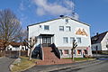
Gasthaus zum Schinderhannes

The Gasthaus zum Schinderhannes is a listed half-timbered house at the central intersection of Usinger-, Emser- and Camberger Straße. The house was originally built in the early 17th century and was rebuilt and expanded in different eras. The male figures on the gable side with curved struts and carved lugs with a heart motif and the profiled entablature zone with angular beam heads and filler wood belong to the original parts of the house. The eaves side framework was added around 1800. In the late 19th century, the roof was changed to its present-day form with a knee and overhang on carved struts, and the gate structure was supplemented with symmetrical grating over two man gates. Today the house is used as a restaurant.
Old school (Protestant parish hall)

Opposite the church, the primary school was built in 1910 and inaugurated in 1912. It was built in the country house style customary at the time . The lower area is designed as a natural stone base. The classrooms were located behind a plastered facade on the ground floor, while the upper part of the house is designed in half-timbered construction. As part of the closure of the dwarf schools in the 1960s, the school location was given up. In 1971 the house became the property of the Protestant parish and has since been used as a Protestant parish hall.
Jewish community
The Jewish cemetery of the former Jewish community Steinfischbach is located north of the village in the field near Landstrasse . The last funeral took place shortly before 1900. Steinfischbach had its own Jewish community since 1828, which by 1840 consisted of ten people. It merged with the community in Bad Camberg around 1845 . In 1907 only one Jewish family lived in the area.
Barrows and quarries
Older traces that people have left there can be found on the barrows “Totenkopf” and “Goldkessel”. Iron ore used to be mined here on the “Glückstein” and in the “Rote Steinkaut”. A quarry for millstones, road gravel, paving stones and boundary stones also served to support the population.

Rectory

town hall

Bakehouse
Culture hall

City partnership memorial stone


societies
- Singers' Association 1861 eV Steinfischbach
- Turn- und Sportverein 1904 eV Steinfischbach
- Volunteer fire brigade Steinfischbach, founded in 1933 (since 1971 with youth fire brigade and 2011 with children's fire brigade )
- Schützenverein "Falke" Steinfischbach 1962 eV
- Nature and Wanderfreunde Steinfischbach 1985 eV
- Chorisma Steinfischbach eV
- Evangelical Singing Circle Steinfischbach
- Theater friends Steinfischbach
Web links
- District Steinfischbach In: Website of the community Waldems.
- Steinfischbach, Rheingau-Taunus-Kreis. Historical local dictionary for Hessen. In: Landesgeschichtliches Informationssystem Hessen (LAGIS).
- Literature on Steinfischbach in the Hessian Bibliography
- Pictures from Steinfischbach im Taunus
Individual evidence
- ↑ a b Steinfischbach, Rheingau-Taunus-Kreis. Historical local dictionary for Hessen. (As of March 28, 2014). In: Landesgeschichtliches Informationssystem Hessen (LAGIS).
- ↑ District Steinfischbach In: Website of the community Waldems, accessed on August 4, 2020.
- ↑ Law on the reorganization of the Obertaunus district and the district of Usingen (GVBl. II No. 330-18) of July 11, 1972 . In: The Hessian Minister of the Interior (ed.): Law and Ordinance Gazette for the State of Hesse . 1972 No. 17 , p. 227 , § 12 ( online at the information system of the Hessian state parliament [PDF; 1,2 MB ]).
- ^ Federal Statistical Office (ed.): Historical municipality directory for the Federal Republic of Germany. Name, border and key number changes in municipalities, counties and administrative districts from May 27, 1970 to December 31, 1982 . W. Kohlhammer, Stuttgart / Mainz 1983, ISBN 3-17-003263-1 , p. 378 .
- ↑ Waldems community

Bermbach | Esch | Niederems with Reinborn | Reichenbach | Steinfischbach | Wüstems
Hamlet: threshing floor