
Hünstetten
| coat of arms | Germany map | |
|---|---|---|

|
Coordinates: 50 ° 15 ' N , 8 ° 12' E |
|
| Basic data | ||
| State : | Hesse | |
| Administrative region : | Darmstadt | |
| County : | Rheingau-Taunus district | |
| Height : | 377 m above sea level NHN | |
| Area : | 50.56 km 2 | |
| Residents: | 10,479 (Dec. 31, 2019) | |
| Population density : | 207 inhabitants per km 2 | |
| Postal code : | 65510 | |
| Primaries : | 06126, 06128, 06438 | |
| License plate : | RÜD, SWA | |
| Community key : | 06 4 39 007 | |
| LOCODE : | DE HU7 | |
| Address of the municipal administration: |
Im Lagerboden 5 65510 Hünstetten |
|
| Website : | ||
| Mayor : | Jan Kraus (Hünstetter list) | |
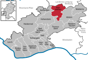
| Location of the community of Hünstetten in the Rheingau-Taunus district | ||
  |
||


Hünstetten is a municipality in the Rheingau-Taunus district in southern Hesse . The seat of the municipal administration is in the Wallbach district .
geography
Geographical location
Hünstetten is located in the Taunus, north of the main ridge between Limburg and the state capital Wiesbaden .
Neighboring communities
Hünstetten borders in the north on the municipality of Hünstelden , in the northeast on the city of Bad Camberg (both in the Limburg-Weilburg district ), in the east on the city of Idstein , in the south on the city of Taunusstein and in the west on the municipalities of Hohenstein and Aarbergen (all Rheingau- Taunus district ).
structure
Hünstetten consists of the following districts :
| Residents | ||
|---|---|---|
| Bechtheim | 886 | |
|
|
Beuerbach | 1157 |
|
|
Görsroth | 1312 |
| Kesselbach | 975 | |
|
|
Ketterschwalbach | 468 |
|
|
Limbach | 729 |
|
|
Oberlibbach | 698 |
|
|
Strinz Trinity | 977 |
|
|
Wallbach | 1065 |
|
|
Wallrabenstein | 2041 |
Total 10,308
The population figures are based on data as of December 31, 2011.
history
Settlement in the Beuerbacher area as early as the Stone Age of 4400 BC Chr. To 3500 BC Is now considered to be secured. This is proven by finds that can be assigned to the Michelsberg culture .
In the course of the regional reform in Hesse , the municipality of Hünstetten was created on January 31, 1971 through the voluntary merger of the six municipalities of Beuerbach, Kesselbach, Ketternschwalbach, Limbach, Strinz-Trinitatis and Wallbach. On July 1, 1972, Oberlibbach was also added on a voluntary basis. On January 1, 1977, Bechtheim, Görsroth and Wallrabenstein were incorporated by state law . Local districts with local advisory councils and local councilors were formed for all formerly independent communities . In the centrally located Wallbach, a new building complex was built for the municipal administration.
politics
Community representation
The local elections on March 6, 2016 produced the following results, compared to previous local elections:
| Parties and constituencies | % 2016 |
Seats 2016 |
% 2011 |
Seats 2011 |
% 2006 |
Seats 2006 |
% 2001 |
Seats 2001 |
||
|---|---|---|---|---|---|---|---|---|---|---|
| SPD | Social Democratic Party of Germany | 26.0 | 8th | 36.6 | 11 | 50.7 | 14th | 56.6 | 17th | |
| CDU | Christian Democratic Union of Germany | 21.4 | 7th | 25.5 | 8th | 35.5 | 10 | 31.4 | 10 | |
| HüLi | Hünstetter list - citizens for Hünstetten | 42.5 | 13 | 25.3 | 8th | - | - | - | - | |
| GREEN | Alliance 90 / The Greens | 10.1 | 3 | 12.6 | 4th | 10.4 | 3 | 9.4 | 3 | |
| FDP | Free Democratic Party | - | - | - | - | 3.4 | 1 | 2.6 | 1 | |
| total | 100.0 | 31 | 100.0 | 31 | 100.0 | 31 | 100.0 | 31 | ||
| Voter turnout in% | 58.4 | 57.2 | 58.1 | 59.8 | ||||||
coat of arms
The official blazon of the coat of arms approved by the Darmstadt State Archives in December 1979 reads “In gold, a red bar between two red flanks, accompanied by four (2.2) above and below by six (2.2.2) blue double-T head shafts . “ The coat of arms was designed by the Bad Nauheim heraldist Heinz Ritt according to the specifications of the community . The ten barrows (technical term: dolmen ) symbolize the ten formerly independent communities and the red letter " H " the first letter of the large community that was established in 1972. The crossbar of the letter H also represents Hühnerstraße (Bundesstraße 417), which separates 4 of 6 districts when viewed from Wiesbaden.
Partner municipality
Hünstetten maintains since 1976 partnerships to Neukirchen in Austria .

Buildings
Economy and Infrastructure
Economic structure
Hünstetten was rural and agriculture still plays a role today. Overall, however, the community has changed to a residential community in the second half of the 20th century. There are around 800 jobs on site; This means that the vast majority of employees earn their living outside the municipality, due to the good road connections mainly in the Rhine-Main area .
traffic
The community is at four kilometers from exit Bad Camberg and eight kilometers from the junction Idstein A 3 well connected to the road network. In addition, the federal road 417 runs through the municipality. The distance to Wiesbaden is 22 km, to Mainz 26 km and to Frankfurt 50 km.
education
- IGS Wallrabenstein ( Integrated Comprehensive School ) in Wallrabenstein
- Raven school (primary school) in Wallrabenstein
- Panorama school (elementary school) in Görsroth
Web links
- Website of the municipality of Hünstetten
- Hünstetten, Rheingau-Taunus district. Historical local dictionary for Hessen. In: Landesgeschichtliches Informationssystem Hessen (LAGIS).
- Literature about Hünstetten in the Hessian Bibliography
Individual evidence
- ↑ Hessian State Statistical Office: Population status on December 31, 2019 (districts and urban districts as well as municipalities, population figures based on the 2011 census) ( help ).
- ↑ Shards from the Stone Age In: Idsteiner Zeitung, May 2, 2011
- ^ Community of Hünstetten, "On the story"
- ^ Municipal reform in Hesse: mergers and integrations of municipalities from June 21, 1972 . In: The Hessian Minister of the Interior (ed.): State Gazette for the State of Hesse. 1972 No. 28 , p. 1197 , point 851 para. 8. ( Online at the information system of the Hessian State Parliament [PDF; 4.4 MB ]).
- ↑ Law on the reorganization of the Rheingau district and the Untertaunus district (GVBl. II 330-30) of June 26, 1974 . In: The Hessian Minister of the Interior (ed.): Law and Ordinance Gazette for the State of Hesse . 1974 No. 22 , p. 312 , § 5 ( online at the information system of the Hessian state parliament [PDF; 1.5 MB ]).
- ^ Federal Statistical Office (ed.): Historical municipality directory for the Federal Republic of Germany. Name, border and key number changes in municipalities, counties and administrative districts from May 27, 1970 to December 31, 1982 . W. Kohlhammer, Stuttgart / Mainz 1983, ISBN 3-17-003263-1 , p. 377-378 .
- ↑ main statute. (PDF; 17 kB) §; 6. In: Website. Hünstetten community, accessed February 2019 .
- ^ Result of the municipal election on March 6, 2016. Hessian State Statistical Office, accessed in April 2016 .
- ^ Hessian State Statistical Office: Result of the municipal elections on March 27, 2011
- ^ Hessian State Statistical Office: Result of the municipal elections on March 26, 2006
- ^ Community of Hünstetten Wappen

Aarbergen | Bad Schwalbach | Eltville am Rhein | Geisenheim | Heidenrod | Hohenstein | Hünstetten | Idstein | Kiedrich | Lorch | Niedernhausen | Oestrich-Winkel | Rüdesheim am Rhein | Snake bath | Taunusstein | Waldems | Walluf
Bechtheim | Beuerbach | Görsroth | Kesselbach | Ketterschwalbach | Limbach | Oberlibbach | Strinz Trinity | Wallbach | Wallrabenstein