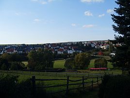
Strinz Trinity
|
Strinz Trinity
Hünstetten municipality
|
|
|---|---|
| Coordinates: 50 ° 14 ′ 7 ″ N , 8 ° 9 ′ 22 ″ E | |
| Height : | 285 m above sea level NHN |
| Area : | 7.07 km² |
| Residents : | 937 (Jun. 30, 2017) |
| Population density : | 133 inhabitants / km² |
| Incorporation : | December 31, 1971 |
| Postal code : | 65510 |
| Area code : | 06126 |
|
panorama
|
|
Strinz-Trinitatis is a district of the municipality of Hünstetten in the Rheingau-Taunus district in southern Hesse .
geography
Strinz-Trinitatis is located in the Taunus north of the main ridge between Limburg and the state capital Wiesbaden . State road 3275 runs through the village .
history
The local area was already settled in the 9th century. Strinz-Trinitatis was first mentioned in a document together with the neighboring town of Strinz-Margarethä in 1184 in a document with which Pope Lucius III. the Bleidenstadt monastery confirmed ownership of both places. Both place names are derived from the Celtic word Stryntz = wasteland and St. Trinity = Trinity off.
In 1184 the place was called Strentzge maiorem . Later it was called Strinziche, Grozen Strinzge, Obirn Strintzige, Hinder strenze, Groszen-Strynzen and Hinderstrintze until it came to Strintzige in Holy Trinity in 1446 . Before 1332, Strinz-Trinitatis became the seat of its own parish . Probably as early as the middle of the 15th century, but no later than 1566, Bleidenstadt's feudal sovereignty was at best only of a formal nature and both Strinz towns belonged to the Nassau-Walram office of Idstein . In 1705 Bleidenstadt also lost the church patronage to Nassau-Idstein. The first school, which is also the first village school in Nassau-Idstein as a whole, dates from 1562. For 1610, 40 households in the village are recorded, for 1700 around 80 inhabitants. Lead ore was mined near the village between 1619 and 1794 .
In the village there is a fortified church , the steeple of which dates from the 12th century and which used to be a fortified tower .
On December 31, 1971, as part of the regional reform in Hesse, the former municipalities of Beuerbach, Kesselbach, Ketternschwalbach, Limbach, Strinz-Trinitatis and Wallbach voluntarily merged to form the new municipality of Hünstetten. Local districts with local advisory councils and local councilors were formed for all formerly independent communities . In the centrally located Wallbach, a new building complex was built for the municipal administration.
The village community center was renamed Dr.-Herbert-Günther-Halle in 2016. The forecourt has been called "Lothar-Häring-Platz" since summer 2017.
In today's municipal area there were probably the desolate places Steinbach, which was probably abandoned in the 15th century and was located in the area of today's municipal boundary to Panrod , and Breitenscheid (probably in the common border area with Görsroth , Oberlibbach and Kesselbach ).
coat of arms
The coat of arms shows a golden shining triangle in blue with a blue eye inside.
literature
- Waldemar Schmidt: Strinz-Margarethä and Strinz-Trinitatis - two Bleidenstadt parishes. in: Nassauische Annalen, 65th Volume, 1954. Pages 229-233
Web links
- Strinz-Trinitatis district. In: Internet presence. Hünstetten municipality
- Local history of Strinz-Trinitatis. ( Memento from October 10, 2017 in the Internet Archive ) In: Internet presence of the municipality of Hünstetten. (PDF file; 2.29 MB)
- Strinz-Trinitatis, Rheingau-Taunus-Kreis. Historical local dictionary for Hessen. In: Landesgeschichtliches Informationssystem Hessen (LAGIS).
- Literature on Strinz-Trinitatis in the Hessian Bibliography
Individual evidence
- ↑ Numbers + Facts. (No longer available online.) In: Website. Hünstetten municipality, archived from the original on August 6, 2016 ; accessed in November 2018 .
- ↑ Budget 2018. (PDF; 530 MB) Hünstetten municipality, p. 2 (preliminary report), PDF p. 294 , accessed in November 2018 .
- ^ Federal Statistical Office (ed.): Historical municipality directory for the Federal Republic of Germany. Name, border and key number changes in municipalities, counties and administrative districts from May 27, 1970 to December 31, 1982 . W. Kohlhammer, Stuttgart / Mainz 1983, ISBN 3-17-003263-1 , p. 377 .
- ↑ main statute. (PDF; 17 kB) §; 6. In: Website. Hünstetten community, accessed February 2019 .


