
Wallrabenstein (Hünstetten)
|
Wallrabenstein
Hünstetten municipality
|
|
|---|---|
.png) |
|
| Height : | 250 (224-251) m above sea level NHN |
| Area : | 8.02 km² |
| Residents : | 2027 (June 30, 2017) |
| Population density : | 253 inhabitants / km² |
| Incorporation : | January 1, 1977 |
| Postal code : | 65510 |
| Area code : | 06126 |

Wallrabenstein is the largest part of the municipality of Hünstetten in the Rheingau-Taunus district in southern Hesse .
geography
Wallrabenstein is located in the Taunus north of the main ridge between Limburg and the state capital Wiesbaden . The state road 3277 runs through the village and the federal motorway 3 runs on the eastern edge of the village .
history
For the first time in 1184 a settlement with the name "Holtzhausen" was mentioned at the location of today's place. Wallrabenstein Castle was built in 1393 . The village has had its current place name since 1446.
On 1 January 1977. Wall Rabenstein was in the course of administrative reform in Hesse in the five years earlier new community Hünstetten powerful state law incorporated . For Wallrabenstein, as for the other districts, a local district with a local advisory board and local councilor was formed.
coat of arms
The silver coat of arms shows a three-pointed red wall growing out of the base of the shield, studded with three black ravens.
Culture and sights
For the cultural monuments of the place see the list of cultural monuments in Wallrabenstein . To be emphasized are:
- Wallrabenstein Castle
- the Protestant church built in 1708
- Cast iron pump well , probably a product of the Michelbacher Hütte from shortly before 1900
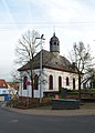
church
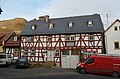
House Burgstrasse 19

House Burgstrasse 1

Fountain

fire Department


education
In the place there is
- an integrated comprehensive school , the IGS Wallrabenstein
- the primary school "Rabenschule"
- the day care center of the Arbeiter-Samariter-Bund
Web links
- Wallrabenstein district. In: Internet presence. Hünstetten municipality
- Local history of Wallrabenstein. ( Memento from February 25, 2018 in the Internet Archive ) In: Internet presence of the municipality of Hünstetten. (PDF; 1.1 MB)
- Wallrabenstein, Rheingau-Taunus-Kreis. Historical local dictionary for Hessen. In: Landesgeschichtliches Informationssystem Hessen (LAGIS).
- Literature on Wallrabenstein in the Hessian Bibliography
Individual evidence
- ↑ Numbers + Facts. In: website. Hünstetten municipality, archived from the original on August 6, 2016 ; accessed in November 2018 .
- ↑ Budget 2018. (PDF; 530 MB) Hünstetten municipality, p. 2 (preliminary report), PDF p. 294 , accessed in November 2018 .
- ↑ Law on the reorganization of the Rheingau district and the Untertaunus district (GVBl. II 330-30) of June 26, 1974 . In: The Hessian Minister of the Interior (ed.): Law and Ordinance Gazette for the State of Hesse . 1974 No. 22 , p. 312 , § 5 ( online at the information system of the Hessian state parliament [PDF; 1.5 MB ]).
- ^ Federal Statistical Office (ed.): Historical municipality directory for the Federal Republic of Germany. Name, border and key number changes in municipalities, counties and administrative districts from May 27, 1970 to December 31, 1982 . W. Kohlhammer, Stuttgart / Mainz 1983, ISBN 3-17-003263-1 , p. 378 .
- ↑ main statute. (PDF; 17 kB) §; 6. In: Website. Hünstetten community, accessed February 2019 .

Bechtheim | Beuerbach | Görsroth | Kesselbach | Ketterschwalbach | Limbach | Oberlibbach | Strinz Trinity | Wallbach | Wallrabenstein