
Werschau
|
Werschau
community breaking
|
|
|---|---|
 |
|
| Height : | 142 m above sea level NHN |
| Area : | 3.89 km² |
| Residents : | 765 (Dec. 31, 2019) |
| Population density : | 197 inhabitants / km² |
| Incorporation : | December 31, 1971 |
| Postal code : | 65611 |
| Area code : | 06438 |
Werschau is the smallest of three districts in the municipality of Brechen in the Limburg-Weilburg district in central Hesse .
Geographical location
The old town center is to the right of the Wörsbach on a flood-free hill near the shore. The A3 and the ICE route Frankfurt-Cologne run on the northern edge of the town . The district has only a small piece of forest on the northeastern edge of the village and is otherwise characterized by agricultural land and a large gravel pit to the west of the village. The settlement itself is 140 meters above sea level. To the southwest, the gently rolling landscape rises up to 200 meters.
The Werschauer district is bordered to the north by Niederbrechen , on the east by Oberbrechen and from south to west to the Hünfeldener districts Dauborn , Neesbach and Nauheim .
history

The oldest traces of the presence of people in the district were discovered in 1953 on the hill between Werschau and Oberbruch, west of the motorway. It was about three clay vessels that are assigned to the Michelsberg culture from the Neolithic Age . In 1959, around 400 meters from this site, the remains of a permanent Hallstatt culture settlement from around 800 BC came to light. The Via Publica between Cologne and Frankfurt could have been important for the establishment of the place . In the late Middle Ages, traffic shifted from the old elevated road to the floodplains of the Emsbach and thus away from Werschau and closer to Oberbruch and Niederbruch. Today's Nauheimer Straße in the village is also an old traffic route and probably represents a feeder to Via Publica from the direction of Hühnerstraße , the Aartal and Diez . Around 100 years after the Landstraße in Emsbach, the road from Niederbruch via Werschau was followed in 1882 Dauborn and shortly afterwards the junction to Nauheim paved, so that the place was directly connected to the trunk road network.
Werschau was first mentioned in a document in 1235. The place name goes back to the name "Au am Wörsbach ". By 1359 at the latest, a fortification consisted of fences and hedges. This enclosure had a gate at which tolls were levied by the County of Diez, and possibly also by Nassau until the 16th century. After the road in the direction of Nauheim was expanded, the first buildings to the left of the Wörsbach were built in 1884.
The town of Bergen, which became deserted in the late Middle Ages, bordered Werschau . While the agricultural land fell to Niederbruch , the church dedicated to St. George and the cemetery went from Bergen to Werschau. The cemetery thus became the main burial place of the Werschauer. The Berger Church was first mentioned in a document in 910. It is therefore one of the oldest church buildings in the region. It remained the parish church for Werschau until 1571.
A church in the village of Werschau itself is mentioned for the first time in 1439 under the patronage of Saint Anthony , which from 1657 was run as a branch chapel of Niederbruch. In 1696 a chapel consecrated to Saint Barbara was built, which later also passed to the Georgspatrozinium and was expanded in 1744 and 1972. In 1711 Werschau received its own parish for the first time.

A school of its own was built between 1684 and 1694, and a new school building in 1884. After the expansion in 1951, the school was closed in 1969 because all the children went to school again after Niederbruch. In 1972 the old building was demolished and a kindergarten was opened in the extension.
In the First World War twelve soldiers from Werschau died, in the Second 29. On March 27, 1945 American troops reached the place. There was a battle on the highway, in which three barns in the village were set on fire. In the following years around 160 displaced people settled in Werschau. In the following decades the place was expanded mainly to the west and south. The older local roads were paved in 1949 and 1961. In 1950 the bank of Wörsbach was fortified in the local area. Six years later the place received a drinking water network. The village community center was completed in 1968.

On July 25, 1966, Werschau was the scene of an accident that attracted attention across Europe. A Belgian bus went off the track on the A3 and fell from the motorway bridge near Werschau. 33 inmates, including 29 school children, died. A trilingual memorial stone at the scene of the accident and a plaque on the town hall commemorate the most serious traffic accident in Germany in 1966.
Since 1976, a partnership has linked Werschau and the French town of Courcy in Champagne .
In June 2012, the number of residents of Werschau more than doubled for five days. Under the patronage of the chairman of the district fire department, Franz-Josef Sehr, the Werschau fire department organized the large district youth fire department tent camp of the district youth fire department Limburg-Weilburg for the first time, to which 1,000 participants traveled. This was one of the main reasons why it was named Fire Brigade of the Month by the Hessian Ministry of the Interior and Sports .
For the listed buildings of the place see the list of cultural monuments in Werschau .
The von Werschau
The first record of a noble family from Werschau was found in 1258 in the entourage of the House of Limburg and is also mentioned several times in the service of the Limburgers and the Isenburg family , who are related to them . In other documents this house appears as "Roiß or Roist von Werse". The family had a permanent house in the village or in the district and probably the Werschauer mill. Her coat of arms showed two black sloping beams in silver, on the helmet a crowned silver swan's head between a silver flight covered with black sloping beams. In the 15th century the family migrated to the lower Sieg and sold their property in the Werschau area. As early as the late 15th, but especially in the early 17th century, members of the family are known to have worked in the Electoral Cologne . Another branch of the family is guaranteed during this time in Lorch and Kamp on the Middle Rhine. In 1731 the von Werschau family with Max Henrich Freiherr Rost von Werst, Lord of Kuchenheim near Euskirchen, died out in the male line.
Rulership history
In the High Middle Ages Werschau belonged to the County of Diez . Since the early 14th century, as part of the decline of the House of Diez, rights and parts of the sovereignty over Werschau were pledged to the House of Limburg and the Archdiocese of Trier . By 1420 at the latest, Kurtrier had completely taken over Werschau. But this was soon pledged to various territorial lords. The Landgraviate of Hesse owned half of the place from 1436 to 1624.
From 1336 Schultheißen (also responsible for Oberbruch) are proven for Werschau , Heimberger in 1557 and Mayor from 1599 , the latter usually with two simultaneous office holders.
The lower jurisdiction in Werschau can be assigned to the parish court in neighboring Nauheim for the first time in 1311. In 1355 the jurisdiction for the location within the ban fences changed to Kirberg , for the rest of the district to Dauborn. Until the early 15th century, jurisdiction was also partially transferred to Kurtrier via the Lords of Limburg. Initially, Limburg, which is now also Electorate of Trier, was the seat of the court, and from 1726 to 1806, the newly created court Niederbruch.
In 1802, Werschau fell through the secularization of Kurtrier to Nassau-Weilburg and thus in 1806 to the new Duchy of Nassau . On December 31, 1971, the previously independent municipalities of Werschau and Niederbruch were merged to form the new municipality of Brechen. Oberbruch was added as a district on April 1, 1974.
The following list gives an overview of the territories in which Werschau was located and the administrative units to which it was subordinate:
- before 1803: Holy Roman Empire , Electorate Trier , Lower Archbishopric, Limburg Office , Niederbruch Court
- from 1803: Holy Roman Empire, Principality of Nassau-Weilburg (through Reichsdeputationshauptschluss ), Limburg Office
- from 1806: Duchy of Nassau , Limburg Office
- from 1816: German Confederation , Duchy of Nassau, Limburg Office
- from 1849: German Confederation, Duchy of Nassau, Limburg District Office
- from 1854: German Confederation, Duchy of Nassau, Limburg Office
- from 1867: North German Confederation , Kingdom of Prussia , Province of Hessen-Nassau , Administrative Region of Wiesbaden , Unterlahnkreis
- from 1886: German Empire , Kingdom of Prussia, Province of Hesse-Nassau, District of Wiesbaden, District of Limburg
- from 1945: American zone of occupation , Greater Hesse , Wiesbaden district, Limburg district
- from 1949: Federal Republic of Germany , State of Hesse , Wiesbaden district, Limburg district
- from 1968: Federal Republic of Germany, State of Hesse, administrative district Darmstadt , district Limburg
- on December 31, 1971, Werschau was incorporated as a district of the newly founded municipality of Brechen.
- from 1974: Federal Republic of Germany, State of Hesse, administrative district Darmstadt, district Limburg-Weilburg
- from 1981: Federal Republic of Germany, State of Hesse, Gießen district, Limburg-Weilburg district
Economic history
Agriculture was the most important line of business for the people of Werschau into the 20th century. Viticulture possibly existed until the beginning of the 15th century, but this was stopped at the end of the Medieval Warm Period . As early as 1878, the first efforts were made to merge the agricultural areas, which had been split up due to the division of inheritance, and to expand the country lanes. In 1950 there were still 35 farms. By 1472 at the latest there was a mill, which was replaced by a new building further upstream in 1859. At the end of 1963 the mill was shut down. An inn was first mentioned in 1613.
In the 18th century and possibly earlier there were attempts to mine iron and silver ore, but these were largely unsuccessful. By 1743 at the latest, sand was mined for construction work in the locality. There is now a large gravel pit to the west of the village.
Together with Neesbach, Nauheim and a few other Märkern, Werschau had a share in an extensive marrow forest that stretched from Heringen and Kirberg to Panrod . This community forest, which was 57 hectares in size, still existed in the 20th century.
Population development
23 households in Werschau are guaranteed for 1684. In 1720 there were 35 households, in 1730 there are reports of 43 men and two widows in the village and in 1790 of 57 houses. In 1803 236 inhabitants are recorded. The population grew to 633 by 1970 and is still mostly Catholic today.
| Werschau: Population from 1834 to 2015 | ||||
|---|---|---|---|---|
| year | Residents | |||
| 1834 | 428 | |||
| 1840 | 461 | |||
| 1846 | 478 | |||
| 1852 | 455 | |||
| 1858 | 465 | |||
| 1864 | 486 | |||
| 1871 | 462 | |||
| 1875 | 406 | |||
| 1885 | 421 | |||
| 1895 | 385 | |||
| 1905 | 388 | |||
| 1910 | 414 | |||
| 1925 | 411 | |||
| 1939 | 394 | |||
| 1946 | 569 | |||
| 1950 | 577 | |||
| 1956 | 536 | |||
| 1961 | 526 | |||
| 1967 | 573 | |||
| 1970 | 633 | |||
| 1978 | 673 | |||
| 1980 | 727 | |||
| 1985 | 763 | |||
| 1991 | 764 | |||
| 1995 | 788 | |||
| 2000 | 757 | |||
| 2010 | 759 | |||
| 2015 | 715 | |||
| Data source: Historical municipality register for Hesse: The population of the municipalities from 1834 to 1967. Wiesbaden: Hessisches Statistisches Landesamt, 1968. Other sources: | ||||
Religious affiliation
Source: Historical local dictionary
| • 1885: | 12 Protestant (= 2.85%), 409 Catholic (= 97.15%) residents |
| • 1961: | 29 Protestant (= 5.51%), 497 Catholic (= 94.49%) residents |
Infrastructure
The Werschau volunteer fire brigade (founded in 1927 and with a youth fire brigade since May 1, 1972 ) provides defensive fire protection and general help.
Culture and sights
societies
The following clubs shape club life in Werschau:
- Werschau volunteer fire brigade , founded in 1927 (since May 1, 1972 with youth fire brigade)
- Friends of "Werschau-Courcy"
- Catholic youth Werschau
- Church choir "St. Georg Werschau "
- Men's choir "Frohsinn 1889 Werschau" , oldest club in Werschau
- Fruit, horticultural and beautification association Werschau
- Table tennis club 1968 Werschau
- Werschauer sports club
Cultural monuments
See the list of cultural monuments in Werschau .
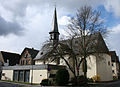
Parish Church of St. George

Old forge, a listed building


literature
- Hellmuth Gensicke: From the history of Werschau. 1985, DNB 890029059 .
- Literature about Werschau in the Hessian Bibliography
Web links
- Website of the community of Brechen
- Werschau, Limburg-Weilburg district. Historical local dictionary for Hessen. In: Landesgeschichtliches Informationssystem Hessen (LAGIS).
Individual evidence
- ↑ Area statistics of the municipality and its districts. In: Internet presence. Community of Brechen, accessed on May 23, 2020 .
- ↑ Figures - data - facts - population figures in brief. In: Internet presence. Community of Brechen, accessed on May 23, 2020 .
- ↑ FLORIAN HESSEN 7 + 8/2013, p. 18 ff.
- ^ Federal Statistical Office (ed.): Historical municipality directory for the Federal Republic of Germany. Name, border and key number changes in municipalities, counties and administrative districts from May 27, 1970 to December 31, 1982 . W. Kohlhammer, Stuttgart / Mainz 1983, ISBN 3-17-003263-1 , p. 369 .
- ↑ a b c Werschau, Limburg-Weilburg district. Historical local dictionary for Hessen. (As of June 8, 2018). In: Landesgeschichtliches Informationssystem Hessen (LAGIS).
- ^ Michael Rademacher: German administrative history from the unification of the empire in 1871 to the reunification in 1990. State of Hesse. (Online material for the dissertation, Osnabrück 2006).
- ↑ Population statistics (development) , municipality of Brechen ( Memento from August 2, 2016 in the Internet Archive )
- ↑ List of associations in the Brechen trade association ( memento of July 2, 2012 in the Internet Archive )