Stückelberg (Taunus)
| Stückelberg | ||
|---|---|---|
|
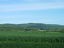
The Stückelberg, in front of it Dombach |
||
| height | 509.7 m above sea level NHN | |
| location | near Dombach ; District of Limburg-Weilburg , Hesse ( Germany ) | |
| Mountains | Taunus | |
| Dominance | 1.5 km | |
| Coordinates | 50 ° 18'59 " N , 8 ° 20'3" E | |
|
|
||

The Stückelberg near Dombach in the Hessian district Limburg-Weilburg is 509.7 m above sea level. NHN high elevation in the Taunus low mountain range .
geography
location
The Stückelberg is located in the eastern Hintertaunus . In the Taunus Nature Park , its summit rises 1.6 km northeast of the Bad Camberg district of Dombach , 2.7 km east-northeast of Schwickershausen , 2.5 km south-southwest of Hasselbach and 1.3 km (depending on the beeline ) west-southwest of Eichelbacher Hof . About 1.5 km north-northwest is the 525.6 m high cow bed . The Emsbach tributary Dombach flows south-west . The Weil tributary, Eichelbach, flows north-east near the Eichelbacher Hof .
The wooded Stückelberg is part of the Feldberg-Langhals-Pferdskopf-Scholle of the eastern Hintertaunus, which separates the Emsbach valley from the Weiltal. After the cow bed it is the second highest mountain in the northwest of this high clod .
Natural allocation
The Stückelberg counts in the natural environment feature unit group Taunus (no. 30) in the main unit Eastern Hintertaunus (302) for natural space horse head Taunus (302.6).
Transport, hiking and leisure
State road 3030 runs north past the Stückelberg and leads from Hasselbach to Schwickershausen. From their Kuhbett car park with a connection to the Rennstraße, there are marked hiking trails that circle the mountain's plateau. The Vogelburg parrot park is located on the lower part of the north-northeast flank of the mountain near the village of Hasselbach .

