Horse head (Taunus)
| Horse head | ||
|---|---|---|
|
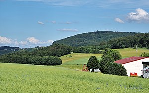
View from Mauloff to the horse's head |
||
| height | 662.6 m above sea level NHN | |
| location | near Treisberg ; Hochtaunuskreis , Hessen ( Germany ) | |
| Mountains | Taunus | |
| Dominance | 4 km → Sängelberg | |
| Notch height | 93 m ↓ Judenkopf | |
| Coordinates | 50 ° 17'25 " N , 8 ° 26'5" E | |
|
|
||
| Development | Track | |
| particularities | Horse head observation tower | |


The horse's head at Treisberg in the Hessian Hochtaunuskreis is 662.6 m above sea level. NHN high mountain in the Taunus low mountain range and after Weilsberg ( 700.7 m ), Dillenberg ( 682.4 m ) and Sängelberg ( 665 m ) the fourth highest elevation in the eastern Hintertaunus .
geography
location
The horse's head is located in the Taunus Nature Park and belongs to the municipality of Schmitten , with the border to the municipality of Weilrod running over its north and west flanks. The mountain, the summit of which rises about 600 m south-southwest of Treisberg (to Schmitten), is located between Hunoldstal in the northeast, Brombach in the east, Dorfweil (all in Schmitten) in the southeast and the Schmitten core town in the south, as well as between Mauloff in the west and Finsternthal (both to Weilrod) in the west-north-west. The Weil flows to the east in an arc around the mountain , first to the northeast and then to the west-northwest in the direction of Lahn , and to the west the Weil tributary, Niedgesbach , runs first to the north-northwest and then to the northeast. While the landscape of the mountain slopes in most directions into the valleys of these brooks, it leads south to the Feldkopf ( 596 m ).
Natural allocation
The horse's head belongs to the natural space main unit group Taunus (number 30), in the main unit Eastern Hintertaunus (302) to the natural space Pferdskopf-Taunus (302.6).
geology
Geologically, the mountain belongs to the so-called Feldberg-Langhals-Pferdskopf-Scholle, which developed in the Tertiary and has great relief differences.
Protected areas
The Sau- and Niedgesbach nature reserve near Schmitten ( CDDA no. 165327; designated 1995; 64 ha ) and the fauna-flora-habitat area Niedges, Sau and Kirrbachtal between Mauloff and Schmitten (FFH no . 5716-306; 104 ha).
Horse head observation tower
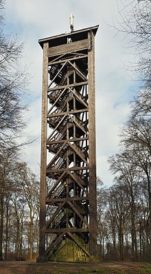
On the horse head stands the 34 meter high horse head lookout tower , which was rebuilt by the surrounding area of Frankfurt and transferred to the community of Schmitten on November 10, 1987. A table and benches were set up at the base of the tower.
The tower offers a panoramic view of the surrounding Taunus heights of the Eastern and Western Hintertaunus, the High Taunus with an almost complete view of the Taunushauptkamm , the central Hochtaunus (Feldberg-Taunuskamm) around the Großer Feldberg ( 881.5 m ) and the Kleiner Feldberg ( 825 , 2 m ) as well as in the Usinger basin and the Weiltal.
In good weather conditions, the view extends to the southwest over the low-lying main incision of the Taunus main ridge near Niederseelbach to the Palatinate Forest , further west to the North Palatinate Bergland with the Donnersberg 83 km away (approx. 687 m ). You can then see:
In the west of the Hunsrück with the Soonwald 67 km away, the Salzkopf ( 627.6 m ), Kandrich ( 638.6 m ), in front of it the Kemeler ridge of the western Hintertaunus with the Mappershainer Kopf ( 548 m ), Grauer Kopf ( 543.4 m ) and the front Hunsrück with the Fleckertshöhe ( 529.8 m ).
In the northwest Westerwald with the Montabaurer Höhe with alarm pole ( 545.2 m ) and Köppel ( 540.2 m ), further northwest in the Niederwesterwald with Malberg ( 422 m ). To the north extends the Hohe Westerwald with Galgenberg ( 649.7 m ), Salzburger Kopf ( 654.2 m ), Homberg ( 635.3 m ) and Höllberg ( 642.8 m ) 44 km away; further north is the Gladenbacher Bergland including Damshauser peaks with a cap ( 493.5 m ), Rimberg ( 497.1 m ) 63 km away and also the basalt cone of the Dünsberg ( 497.7 m ).
In the northeast of the Kellerwald with the Hohen Lohr ( 656.7 m ) and the Hunsrück ( 635.9 m ) 93 km away; in the east the Vogelsberg with Taufstein ( 773 m ) 63 km away and the Herchenhainer Höhe ( 733.1 m ).
Southeast the Rhön with the Wasserkuppe ( 950 m ) in 109 km, the Heidelstein ( 925.7 m ) in 113 km, the Dammersfeldkuppe ( 927.9 m ) in 102 km, the Kreuzberg ( 927.8 m ) in 110 km away and the Dreistelzberg ( 660.4 m ) 95 km away .
There are cell phone antennas on the tower roof .
Sport and hiking
On the slope of the Pferdskopf in Treisberg there are two ski lifts that open up the steepest ski slope in the Taunus. If the snow conditions allow, there is also a much-used toboggan slope that leads down almost to the road to Mauloff .
The horse head forest nature trail runs along the mountain , with information boards providing information about the flora and fauna of the typical low mountain range.
gallery
Horse head (left) and Großer Feldberg
Horse head (left) and Großer Feldberg
View from the district of Mauloff
View of the horse's head on the horizon from the valley between Sängelberg (left) and Pfaffenrod (right); in the middle in front of the horse's head the eastern extension of the Judenkopf can be seen .
Landstein ruins
About 1.9 km north of the horse head summit is the Landstein ruin in the Weiltal . The former Liebfrauen pilgrimage church from the 15th century was destroyed in the Thirty Years' War (1618–1648) and never rebuilt. The ruins of the west tower with two two-storey side rooms have been preserved.
See also
Web links
- The horse's head on taunus.info
- Panorama from the horse's head on panorama-photo.net


