
Dorfweil
|
Dorfweil
commune Schmitten
|
|
|---|---|
 |
|
| Height : | 404 (554–) m above sea level NHN |
| Area : | 3.67 km² |
| Residents : | 684 (2006) |
| Population density : | 186 inhabitants / km² |
| Incorporation : | August 1, 1972 |
| Postal code : | 61389 |
| Area code : | 06084 |

Dorfweil is a part of the community Schmitten in the Hessian Hochtaunuskreis .
geography
Dorfweil is located in the Weiltal of the eastern Hintertaunus and has numerous hiking trails. Among other things, the Weiltalwanderweg leads through the village. With an area of 367 hectares and 684 inhabitants (as of the end of 2004), Dorfweil is one of the smaller districts of Schmitten. Neighboring towns are Treisberg (northwest), Brombach (north), Arnoldshain (south) and Schmitten (southwest).
history
Dorfweil was first mentioned in 772. Presumably the place was founded because of the ore deposits. In the late 14th century, the parish of Rod am Berg , to which the towns of Rod am Berg, Brombach, Hunoldstal (then Hundstall) and Dorfweil belonged, formed the Stockheim Higher Court , which was part of the Stockheim Court. In the 15th century, the place consisted of the two settlements Vorder- and Hinterwylen / Ober- and Niederweiler, which then became Dorfweil.
In the course of administrative reform in Hesse was until then independent municipality Dorfweil powerful state law with other, previously independent municipalities, to today's on August 1, 1972 (large) municipality Schmitten together . Dorfweil has been part of the Schmitten community since then .
religion
Above the village community center is the Dorfweiler church, which is the second church of the Protestant parish Rod am Berg. It was built by the congregation in 1906 so that one no longer had to walk the long way to Rod am Berg to attend church services. The small organ was installed shortly after the building was completed. Originally there were 2 bells in the tower , one was melted down during World War II , and over the years two new ones were added, so that there are 3 bells today. The service here usually takes place every two weeks.
coat of arms
In 1953 the Dorfweiler coat of arms was designed, the community wanted to record mining activities in the village in a coat of arms. Blazon: A black hammer and a black mallet crossed diagonally in the gold ground.
Culture and sights
Cultural monuments
For the listed buildings see the list of cultural monuments in Dorfweil .
dialect
The language of the hamlets and the other Hochtaunusdörfer is very similar, but there are exceptions. The cause of this phenomenon is likely to be the influence of the Westerwald or Wetterau dialect in the villages downstream, while the Lower Main idiom has shaped the language in the upper villages through various connections since ancient times.
War memorial
The village-like war memorial stands on a traffic island at the junction of the Ringstrasse and Brombacher Strasse . The sculpture created by August Bischoff shows a grieving seated female figure. The woman is sitting on a block with a soldier's head carved on the back. The memorial is located on a pedestal with the inscription "In memory of our heroes from 1914 - 1918 - the community of Dorfweil". There are also boards with the names of the fallen residents of Dorfweil.
Infrastructure
The family vacation home of the Evangelical Free Churches in Dorfweil is open to families and conference guests. The small indoor swimming pool of the family holiday facility can also be used by swimmers who are not overnight guests of the family holiday facility.
On August 13, 1988, the old school in Dorfweil was demolished. The demolition was politically controversial as the house was on a work list of the State Office for Monument Preservation. Today the community-owned village community center "Haus Wilina" stands on this square. It is managed and used for celebrations.
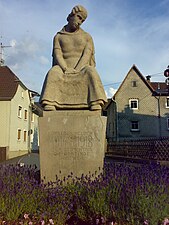
War memorial

Side view
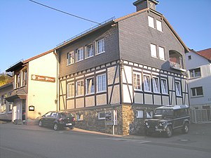
"House Wilina"
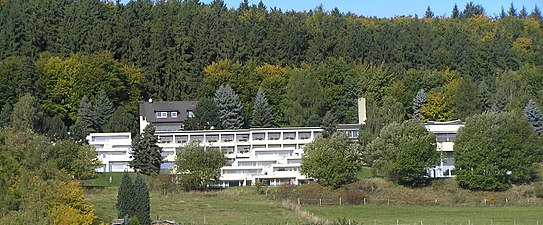
Family vacation spot


Web links
- Dorfweil district on the Schmitten community's website.
- Dorfweil, Hochtaunuskreis. Historical local dictionary for Hessen. (As of November 11, 2014). In: Landesgeschichtliches Informationssystem Hessen (LAGIS).
- Literature about Dorfweil in the Hessian Bibliography
Individual evidence
- ↑ a b Municipality of Schmitten: districts ( Memento from May 2, 2007 in the Internet Archive )
- ↑ Law on the reorganization of the Obertaunus district and the district of Usingen (GVBl. II 330-18) of July 11, 1972 . In: The Hessian Minister of the Interior (ed.): Law and Ordinance Gazette for the State of Hesse . 1972 No. 17 , p. 227 , § 4 ( online at the information system of the Hessian state parliament [PDF; 1,2 MB ]).
- ↑ Angelika Baeumerth: Chronicle 1972-2000 Hochtaunuskreis. 2001, DNB 96227755X , p. 164.
.png)
Arnoldshain | Brombach | Dorfweil | Hunoldstal | Niederreifenberg | Oberreifenberg | Schmitten | Seelenberg | Treisberg