Mappershainer head
| Mappershainer head | ||
|---|---|---|
|
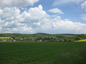
Mappershainer head (center), in front of it Langschied |
||
| height | 548 m above sea level NHN | |
| location | at Mappershain ; Rheingau-Taunus-Kreis , Hessen , ( Germany ) | |
| Mountains | Taunus | |
| Dominance | 11.2 km → Erbacher Kopf | |
| Notch height | 72 m ↓ | |
| Coordinates | 50 ° 10 ′ 31 ″ N , 7 ° 59 ′ 24 ″ E | |
|
|
||
The Mappershainer head near Mappershain in the Hessian Rheingau-Taunus-Kreis is an elevation in the low mountain range Taunus and with 548 m above sea level. NHN the highest in the western Hintertaunus .
geography
location
The Mappershainer Kopf is located in the western Hintertaunus in the Rhein-Taunus Nature Park . Its peak rises around 500 m northwest of Mappershain and around 1.5 km east-southeast of Langschied . About 1 km east of the elevation, on which part of the Kemeler Heide extends, is the watershed point between the Dörsbach in the north and the Wisper in the west, both of which arise here, as well as the Aar in the east.
About 5 km on the Kemeler Ridge north-west of the Mappershainer Kopf, the second highest point in the western Hintertaunus is the Graue Kopf with 543.4 m .
Natural allocation
The Mappershainer head belongs to the natural spatial main unit group Taunus (No. 30) and in the main unit Westlicher Hintertaunus (304) to the subunit Westlicher Aartaunus (304.1), whereby its landscape drops to the southwest into the subunit Wispertaunus (304.0).
Traffic and walking
The federal highway 260 (partly also called Bäderstraße Taunus ) runs about 500 m northeast past the summit of the Mappershainer Kopf and reaches a height of about 515 m there . From this road branches off about 1 km (as the crow flies) east of the summit, the county road 680 as a spur road leading to Mappershain. For example, starting at these roads you can hike the mountain on forest paths and paths.
See also
Individual evidence
- ↑ a b c Map services of the Federal Agency for Nature Conservation ( information )
- ↑ Dominance and prominence according to TK 25

