Alarm bar (mountain)
| Alarm bar | ||
|---|---|---|
|
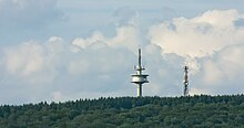
View from Quirnbach south-south-west to the Montabaurer Höhe |
||
| height | 545.2 m above sea level NHN | |
| location | with horresses ; Westerwaldkreis , Rhineland-Palatinate ( Germany ) | |
| Mountains | Westerwald | |
| Dominance | 29 km → Marienberger Höhe ( Westerwald ) | |
| Notch height | 251.2 m ↓ in Siershahn | |
| Coordinates | 50 ° 25 '30 " N , 7 ° 44' 2" E | |
|
|
||
| particularities | two telecommunications towers | |
The alarm bar is 545.2 m above sea level. NHN the highest elevation of the Montabaurer Höhe , a mountain range on the southwest edge of the Westerwald . It is located near Horressen in the Rhineland-Palatinate Westerwaldkreis . Together with the Köppel and the Lippersberg , the alarm pole forms the center of the ridge on which the largest contiguous forest area in the Westerwald extends.
Surname
The alarm pole owes its name to the fact that in 1809 French soldiers installed an optical signal system there. In 1853 a pillar was erected here, which served as a trigonometric point for mapping the Rhineland , which was started by Jean Joseph Tranchot and then continued by Friedrich Carl Ferdinand von Müffling . From 1894 it was used for the Prussian land survey . The pillar was moved five meters in 1969 and a granite pillar was placed in its original location.
geography
location
The alarm bar rises in the Nassau Nature Park . The border between the town of Montabaur , whose core town is 7 km east-northeast of the summit, to the municipality of Hillscheid , whose core town is 3.5 km southwest of the summit, runs northwest over west to southwest around the summit region belonging to the town of Montabaur. To the east-northeast the landscape leads to Köppel, 1.5 km away .
On the northern flank the Vorderste Bach and the Hinterste Bach arise as source brooks of the Brexbach and on the southern slope the Biebrichsbach as the source brook of the Stadtbach . To the south lies the Wolfsborn as the source of the small Wolfsgraben, which flows into the Kalterbach near the alarm pole just like the small Alsbach, which rises in the southwest . The source of the Feisternachtbach (Kühlbach) lies on the western slope .
Parts of the fauna-flora-habitat area Montabaurer Höhe (FFH no. 5512-301; 28.11 km² ) are located on the summit region and the southern flank of the alarm pole .
Natural allocation
The alarm rod belongs to the natural spatial feature unit group Westerwald (no. 32) and in the main unit Lower Westerwald (324) for the subunit Montabaurer height (324.1).
Mountain height
The alarm bar is 545.2 m high. About 150 m southwest of the summit, a 542.5 m high point is noted on topographic maps . In atlases and maps the mountain height is given as 545 m .
Telecommunication towers and measuring station
About 130 m southwest of the summit of the alarm pole is the 99 m high Hillscheid alarm pole ( ⊙ ) of the German radio tower , built in 1971, with an amateur radio relay. The Neuhäusel air quality measuring station , which is part of the ZIMEN network of the State Office for the Environment , is located 150 m west of this tower . Another telecommunications tower is located about 20 m west of the summit.
Traffic and walking
Over the southern slope of the Montabaurer Höhe and the alarm pole runs between Hillscheid and federal road 49, roughly in a west-east direction, state road 309 with the German Limes road . It runs there near the Wolfsgraben at a height of about 420 m and meets the B 49 at 424.3 m .
The European long-distance hiking trail E1 runs east of the alarm pole over the Montabaurer Höhe and the Köppel there . The Thielshütte refuge, built in 1967, is located on the western slope of the alarm pole, next to a branch in the forest and hiking trail ( 499.2 m ) .
Web links
Individual evidence
- ↑ a b c d e f Map service of the landscape information system of the Rhineland-Palatinate nature conservation administration (LANIS map) ( notes )
- ↑ North of the center of Siershahn map service of the landscape information system of the Rhineland-Palatinate nature conservation administration (LANIS map) ( notes )
- ↑ Alarm bar and Köppel in Köppel , on ich-geh-wandern.de
- ↑ Trigonometric point "Montabaurer Höhe" information board on the alarm pole next to the pillar
- ↑ Map services of the Federal Agency for Nature Conservation ( information )
- ↑ Heinrich Müller-Miny, Martin Bürgener: Geographical land survey: The natural spatial units on sheet 138 Koblenz. Federal Institute for Regional Studies, Bad Godesberg 1971. → Online map (PDF; 5.7 MB)
- ↑ Mountain height according to Der Große Falk Atlas - Deutschland Detailkarten , M = 1: 200,000, 2004/2005, ISBN 978-3-8279-0381-5
- ↑ Air measurement network ZIMEN - location characteristics and equipment. Retrieved August 10, 2016 .


