
Upper Middle Rhine Valley

The Upper Middle Rhine Valley is a natural spatial main unit within the main unit group Middle Rhine area on the Middle Rhine . It extends up the Rhine in the southeast to a line that connects the Rochus Chapel in Bingen with the Niederwald monument in Rüdesheim , and down the Rhine in the northwest to the Lahn estuary in Lahnstein , directly above Koblenz .
The Upper Middle Rhine Valley is located in Rhineland-Palatinate , on the southern eastern bank also in Hesse , and separates the Taunus in the east from the Hunsrück in the west.
On 27 June 2002 has been Rhine Gorge with the slightly extended northward course to the Mosel mouth in Koblenz on the List of World Heritage of UNESCO added.
Natural structure
The Upper Middle Rhine Valley is structured as follows:
-
(to 29 - Middle Rhine area )
- 290 Upper Middle Rhine Valley
- 290.0 Binger Gate
- 290.1 Bacharach Valley
- 290.2 St. Goarer Tal
- 290.3 Boppard snares
- 290.4 Lahnstein Gate
- 290 Upper Middle Rhine Valley
Binger gate

The Binger gate covers the Rhine valley from Rüdesheim / Bingen up to and including Trechtingshausen . It separates the left bank, Rhineland-Palatinate Bingen Forest from the right side and Hessian High Taunus with the Niederwald and the north subsequent Rheingaugebirge . With an average width of around 300 m, the Rhine is only half of its width before it enters the gate at Rüdesheim.
In Bingen the Nahe flows into the Rhine from the left. At the Binger Loch , one kilometer downstream , the Rhine changes its direction from west to north, which it changes towards the end of the gate to the northwest. In the Binger Pforte, the ridges on both sides of the Rhine are only about 2 km away from each other and the steep slopes often begin directly on the river bank.
Bacharach valley

The Bacharach valley comprises the Rhine valley from Niederheimbach via Lorch , Bacharach and Kaub to above Oberwesel . It separates the south-east half of the south - eastern Rheinhunsrück in Rhineland-Palatinate on the left bank of the Rhine from the right-hand and predominantly Hessian Wispertaunus and the south of the Middle Rhine Taunus , which adjoins the north on Rhineland-Palatinate soil .
In Lorch, the Wisper flows from the right , the estuary of which cuts first along the city to the northeast, then to the east into the ridges. Similarly, in Bacharach, the valley cuts to the left of the Münzbach estuary. When the Rhine emerges, the river is a good 300 m wide.

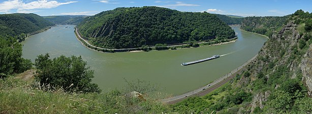
Course of the Rhine between Trechtingshausen and Bacharach, taken from the Siebenburgenblick observation tower .

St. Goar Valley
The St. Goarer Tal encompasses the curvy Rhine valley from Oberwesel via St. Goar and St. Goarshausen to just above Bad Salzig . It lies entirely in Rhineland-Palatinate and separates the northwest half of the south - eastern Rheinhunsrück on the left bank of the Rhine from the central right-hand part of the Middle Rhine Taunus .
In several curves including up to 90 °, the Rhine narrows to less than 200 m. The banks are narrow and therefore offer little settlement area in the immediate vicinity of the river. There are towering steep slopes , in the high altitude there is a gently undulating plateau character , increasing with increasing distance from the Rhine. A typical example of this type of ground relief and world-famous is the Loreley , located in the center of this natural area.
With the exception of the cities mentioned, almost only the slopes and altitudes are populated.
The southern section of the St. Goarer Valley between Oberwesel and the Loreley from the Spitznack viewpoint

View from the Hindenburghöhe on the transition from the St. Goarer Tal to the Bopparder Schlingen near Bad Salzig


Boppard snares
The Bopparder Schlingen encompass the Rhine valley from Bad Salzig via Boppard to the narrowing of the valley immediately above Lahnstein . The valley basin lies entirely in Rhineland-Palatinate and separates the Middle and Waldeschen Rheinhunsrücks on the left of the Rhine from the right-hand north of the Middle Rhine Taunus .
Immediately at the eponymous place, the river describes a right-hand turn by more than 180 ° ( Bopparder Hamm ), starting from a slight left-hand bend , and then making a 135 ° left-hand bend at Osterspai . On the outside of each curve, the slopes are noticeably steep.
Lahnstein Gate
The Lahnsteiner Pforte only encompasses the narrow valley of the Rhine valley directly in the area of the Lahn estuary in Lahnstein . It is located entirely in Rhineland-Palatinate , at the junction of the northeast of the Waldesches Rheinhunsrück on the left, the northwest of the Middle Rhine Taunus on the right in the south, the Lower Lahn valley on the right in the center and the extreme southwest of the Horchheimer Höhe ( Niederwesterwald ) on the right in the north.
Immediately above the almost 5 km long gate, the uppermost section of the Middle Rhine basin joins the Neuwied Rhine valley widening . However, its part above the mouth of the Moselle is commonly still counted as part of the Upper Middle Rhine.
Area between the mouth of the Lahn and the Moselle
The Rhine from above the mouth of the Lahn near Lahnstein to the mouth of the Moselle at the Deutsches Eck in Koblenz already belongs to the Neuwied Rhine Valley expansion (291.0) as the center of the Neuwied Basin and thus to the Middle Rhine Basin (291). However, it is explicitly listed as part of the world cultural heritage. This is also not illogical insofar as the Moselle valley and the Gießen-Koblenzer Lahntal represent the continuations of one and the same valley basin on the left and right of the Rhine.
Tributaries
The following tributaries, which flow into the Upper Middle Rhine Valley, are arranged up the Rhine, from north to south:
| Surname | Inflow side | Length [km] |
Catchment area [km²] |
Mouth height [m. ü. NN] |
Mouth | section | Streets | DGKZ |
|---|---|---|---|---|---|---|---|---|
| Moselle | Left | 544.0 | 28153.3 | 61 | Koblenz | New expansion of the Rhine valley | B 49 , B 416 | 26th |
| Mühlenbach | right | 6.9 | 10.6 | 61 | KO Ehrenbreitstein | New expansion of the Rhine valley | K 20 | 25-98 |
| Rhine pool | Left | 4.2 | 5.7 | 62 | KO-Oberwerth | New expansion of the Rhine valley | B 327 | 25-92 |
| Koenigsbach | Left | 0.9 | 0.8 | 62 | KO-Stolzenfels | New expansion of the Rhine valley | 25-912 | |
| Lahn | right | 245.6 | 5924.5 | 63 | Lahnstein | Lahnstein Gate | B 260 | 25-8 |
| Ahrbach | Left | 7.3 | 9.6 | 64 | Rhens | Boppard snares | 25-794 | |
| Zollbach | right | 7.0 | 30.5 | 67 | Braubach | Boppard snares | L 335 * | 25-78 |
| Dinkholderbach | right | 3.9 | 6.1 | 67 | opposite Oberspay | Boppard snares | 25-778 | |
| Muhltalbach | Left | 6.0 | 15.6 | 67 | Boppard | Boppard snares | L 207 | 25-776 |
| Brother Michels Talbach | Left | 3.7 | 8.0 | 68 | Boppard | Boppard snares | 25-7752 | |
| Salzigerbach | Left | 3.4 | 6.4 | 68 | Bad Salty | Boppard snares | L 212 | 25-7738 |
| Wellmicher Bach | right | 9.3 | 25.6 | 69 | Wellme | St. Goar Valley | L 334 | 25-772 |
| Gründelbach | Left | 9.2 | 24.0 | 69 | St. Goar | St. Goar Valley | L 206 | 25-76 |
| Hasenbach | right | 9.4 | 35.4 | 69 | St. Goarshausen | St. Goar Valley | B 274 | 25-74 |
| Forstbach | right | 12.1 | 27.0 | 70 | St. Goarshausen | St. Goar Valley | L 338 | 25-738 |
| Urbach | right | 6.1 | 6.2 | 71 | towards Urbar | St. Goar Valley | 25-7374 | |
| Niederbach | Left | 10.7 | 21.5 | 71 | Oberwesel | St. Goar Valley | 25-7372 | |
| Oberbach | Left | 10.0 | 26.3 | 71 | Oberwesel | St. Goar Valley | L 220 | 25-736 |
| Holzbach | right | 5.2 | 7.4 | 71 | Chew | Bacharach valley | L 339 | 25-734 |
| Münzbach | Left | 6.2 | 19.7 | 72 | Bacharach | Bacharach valley | L 224 | 25-732 |
| Gailsbach | Left | 5.7 | 10.4 | 73 | Rheindiebach | Bacharach valley | K 27 | 25-72 |
| Whisper | right | 29.7 | 209.1 | 73 | Lorch | Bacharach valley | L 3033 | 25-6 |
| Heimbach | Left | 6.2 | 14.8 | 74 | Niederheimbach | Bacharach valley | K 28 | 25-58 |
| Bodentaler Bach | right | 2.2 | 3.6 | 75 | opposite Trechtingshausen | Binger gate | 25-56 | |
| Morgenbach | Left | 6.9 | 14.9 | 76 | before Trechtingshausen | Binger gate | 25-54 | |
| Aulhausener Bach ( Eichbach ) | right | 4.0 | 8.1 | 77 | Assmannshausen | Binger gate | L 3034 | 25-52 |
| Near | Left | 125.1 | 4067.1 | 78 | Bingen | Binger gate | B 9 , B 48 | 25-4 |
(*: The L335 follows the left tributary Dachshausener Mühlbach )
In addition to the large rivers Nahe, Lahn and Mosel, which flow clearly at the ends, only the Wisper can still be described as a river in terms of the amount of water .
The discharges (MQ) of the rivers mentioned are:
- Moselle 315 m³ / s
- Lahn 54 m³ / s
- Nearly 30.3 m³ / s
- Wisper 1.271 m³ / s
See also
Individual evidence
- ^ Document on Unesco World Heritage. (PDF; 440 KiB) (No longer available online.) In: rheingau-taunus.de. Archived from the original on December 11, 2015 ; accessed on October 30, 2017 . Info: The archive link was inserted automatically and has not yet been checked. Please check the original and archive link according to the instructions and then remove this notice.
- ↑ a b c d e f g Heinrich Müller-Miny, Martin Bürgener: Geographical land survey: The natural spatial units on sheet 138 Koblenz. Federal Institute for Regional Studies, Bad Godesberg 1971. → Online map (PDF; 5.7 MB)
- ↑ Map service of the landscape information system of the Rhineland-Palatinate nature conservation administration (LANIS map) ( notes )
- ↑ Landscape profile of the large landscape 29 of the landscape information system of the nature conservation administration Rhineland-Palatinate ( notes )
- ↑ Map and legend of the natural areas of Hesse (online copy of Die Naturraum Hessens , Otto Klausing 1988) in the Hessen Environmental Atlas of the Hessian State Office for Environment and Geology
- ↑ Harald Uhlig: Geographical land survey: The natural space units on sheet 150 Mainz. Federal Institute for Regional Studies, Bad Godesberg 1964. → Online map (PDF; 4.7 MB)
- ↑ Landscape profile of the landscape area 290.0 of the landscape information system of the Rhineland-Palatinate nature conservation administration ( notes )
- ↑ Landscape profile of the landscape area 290.1 of the landscape information system of the Rhineland-Palatinate nature conservation administration ( notes )
- ↑ Landscape profile of the landscape area 290.2 of the landscape information system of the Rhineland-Palatinate nature conservation administration ( notes )
- ↑ Landscape profile of the landscape area 290.3 of the landscape information system of the nature conservation administration Rhineland-Palatinate ( notes )
- ↑ Landscape profile of the landscape area 290.4 of the landscape information system of the Rhineland-Palatinate nature conservation administration ( notes )
- ↑ Landscape profile of the landscape area 291.0 of the landscape information system of the Rhineland-Palatinate nature conservation administration ( notes )
- ↑ GeoExplorer of the Rhineland-Palatinate Water Management Authority ( information )
- ↑ Water map service of the Hessian Ministry for the Environment, Climate Protection, Agriculture and Consumer Protection ( information )