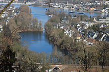
Koblenz-Oberwerth
| Koblenz-Oberwerth | |
|---|---|
| Basic data | |
| District since: | founding |
| Area : | 1.27 km² |
| Residents : | 1,364 (Sep 30, 2012) |
| Population density : | 1070 inhabitants per km² |
| Postal code : | 56075 |
| Area code : | 0261 |
| License plate : |
KO
|
Koblenz-Oberwerth is a district of Koblenz . The former island on the western bank of the Rhine is in the north of the residential area and in the south from the Sportpark Oberwerth the stadium of TuS Koblenz coined. Both parts are separated by the railway embankment that leads to the Horchheimer Bridge and the connection points to the Südbrücke . In addition, the peninsula, which was only populated at the beginning of the 20th century, is home to the outdoor pool and the most powerful waterworks in the city of Koblenz.
history


On the Oberwerth, which was an island until the 19th century and only separated from the mainland by the Lache (a narrow arm of the Rhine), there was a Benedictine monastery since 1143 . Buildings from the 15th and 18th centuries are documented. After the monastery had survived a major flood in 1784, the aristocratic canons had to leave the island in 1794 because of the conquest of the left bank of the Rhine by French revolutionary troops. The monastery was dissolved during the secularization in 1802, then sold and used for other purposes or rebuilt. The last buildings were blown up in the 1930s.
With the construction of the Horchheim railway bridge in the 1870s and the partial filling of the southern arm of the Rhine, it lost its island character. In the 19th century, the northern part of the island was owned by the von Pfaffenhofen-Chleodowski family, who gradually sold it. Ludwig Freiherr von Pfaffenhofen-Chleodowski had a villa built for himself on the Oberwerth in 1911 . On the northern tip was the pioneer training area of the 1st Rhenish Pioneer Battalion No. 8 , on which a lido was built in the 1920s and finally an outdoor pool in 1954 .
The island was not opened up for settlement until the early 20th century. For this purpose, a development plan was drawn up for the northern part in 1900/01 and the Oberwerther Bridge over the Rheinlache was completed in 1909. North of the former monastery, the Royal Prussian Teachers ' Seminar was built between 1907–1908 and housed the University of Koblenz-Landau from 1990–2002 , and in 1912 the civil servants' settlement in Oberwerth along the embankment . In addition, many villas and buildings for French officers were built in the 1920s.
The southern part of Oberwerth was initially used as garden land with a few nurseries . The first waterworks was built here in 1886 and is still the most powerful in the city to this day. In addition, the first sports facilities were built around 1900, which received wooden stands in 1912. As part of a job creation program of the Nazis 1934-1935 was Oberwerth Stadium built, which is to this day in modified form.
Today the Oberwerth is just a peninsula . The Rheinlache was partially filled up with the rubble from the houses destroyed in air raids in Koblenz in World War II .
Buildings
The following structures are located on the Oberwerth:
- Sportpark Oberwerth with the Oberwerth Stadium and the CGM Arena
- Monument to Kaiser Wilhelm I and Empress Augusta (1879)
- The preserved pumping station II from 1904 of the first waterworks
- The former Royal Prussian Teachers' Seminar from 1908
- The Oberwerth civil servants' settlement was built between 1912 and 1926
traffic
The Oberwerth is bordered in the west by the routes of the B 9 and the left Rhine route as well as the Rheinlache with a marina . Since the 1870s, Oberwerth has been divided in the middle by a railway embankment, a junction of the left Rhine route to the Horchheimer railway bridge . The largest transport project in Koblenz was the construction of the south bridge from 1969 to 1975 . The feeder route of the B 327 standing on stilts with connections to the B 9 has dominated the image of the former Rhine island since then.
literature
- Herbert Dellwing (editor): Cultural monuments in Rhineland-Palatinate. Monument topography Federal Republic of Germany. Volume 3.1: City of Koblenz. Southern suburb and Oberwerth. Schwann, Düsseldorf 1986. ISBN 3-590-31033-2
- Ulrike Weber (edit.): City of Koblenz. City districts (= monument topography Federal Republic of Germany . Cultural monuments in Rhineland-Palatinate. Vol. 3, 3). Werner, Worms 2013, ISBN 978-3-88462-345-9 .
Web links
- Short portrait with a film about Oberwerth on SWR television
- Historical information about Oberwerth in: regionalgeschichte.net
- Literature about Koblenz-Oberwerth in the Rhineland-Palatinate state bibliography
Documents
- Picture by Oberwerth from JF Dielmann, A. Fay, J. Becker (draftsman): FC Vogel's panorama of the Rhine, pictures of the right and left banks of the Rhine, FC Vogel lithographic institution, Frankfurt 1833
- Image 2 from Oberwerth, ditto
Coordinates: 50 ° 20 ′ 25 ″ N , 7 ° 35 ′ 30 ″ E


