
Koblenz-Bubenheim
| Koblenz-Bubenheim | |
|---|---|
  |
|
| Basic data | |
| District since: | 1970 |
| Area : | 3.28 km² |
| Residents : | 1,489 (April 30, 2016) |
| Population density : | 454 inhabitants per km² |
| Postal code : | 56070 |
| Area code : | 0261 |
| License plate : |
KO
|
| District | |
| Mayor : | Mike Karen (CDU) |

Koblenz-Bubenheim is a district of Koblenz . The district, which was incorporated in 1970, is located in the north of the city between Kesselheim and Rübenach . There is a small housing estate and a commercial area on the B 9 .
history
The history of Bubenheim begins in pre-Christian times. Found broken glass, remains of fire and pieces of burnt clay suggest that a settlement from the more recent Hallstatt period must have been here. Excavations in 1881 brought the foundations of a larger Roman villa with bathrooms and heated rooms to light east of the village . In 1961 a Roman equestrian helmet was found. On the north side of the Bubenheimer Berg there is an extensive burial ground from the Merovingian era .
There are two theories as to the origin of the name Bubenheim. The first says that it goes back to the expression Heim des Bubo (a Franconian landowner) and should belong to a group of place names of Franconian origin, which designate the first inhabitant and is dated to the 8th century, which also means the approximate age of Bubenheim is indicated. Others claim that the village got its name from the provost Bubo of St. Castor's monastery . The first written mention of the place Buobenheim goes hand in hand with the foundation of a chapel in 1052 by the noble widow Glismuot.
The German Order Coming Koblenz , the Cistercian monastery Himmerod and the Kartause Koblenz owned real estate in Bubenheim. The Koblenz monastery of St. Florin had a court here from 1303 until the 18th century, as did the Besselich monastery and the cathedral monastery from Aachen until the secularization at the beginning of the 18th century. Several mills were operated on the Bubenheimer Bach .
Since the 15th century, Bubenheim belonged to the Trier Ministry of Mountain Maintenance , which was named after the court on the Bubenheimer Berg. In French times (1794-1814) the place belonged to the Mairie Bassenheim in the canton of Rübenach ( Arrondissement de Coblence ). After that, Prussia took over Bubenheim and it was assigned to the Bassenheim office in the Koblenz district . Until after 1918, the Bubenheim farmers supplied the Koblenz people with potatoes and milk. On November 7, 1970, Bubenheim was incorporated into the city of Koblenz. Today there is a service center as well as a commercial and technology park for the city of Koblenz in the Bubenheim area.
politics
Local advisory board
A local district was formed for the Bubenheim district . The local advisory board consists of seven advisory board members, the chair of the local advisory board is chaired by the directly elected mayor.
For the composition of the local council, see the results of the local elections in Koblenz .
Mayor
The mayor is Mike Karen (CDU). In the direct election on May 26, 2019, he prevailed against the previous incumbent Werner Bastian (FBG) with a 55.80% share of the vote.
Attractions
graveyard
The small cemetery on Malterstrasse was created in 1922. It is strictly symmetrical and completely surrounded by a hedge. The following types of graves can be found: election, row, urn rows - and urn election graves. The main path lined by hazel trees leads from the heavy iron gate at the entrance to the Hochkreuz behind the open funeral area. There are no war graves and no historical grave crosses in the cemetery. The city of Koblenz is responsible for the cemetery.
Other structures
- Catholic Chapel of St. Maternus
- Well chapel Bubenheim
- Old school from 1848
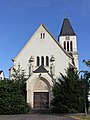
Chapel of St. Maternus

Old school

St. Maternus Street

View of the street "In den Wiesen"


literature
- Bubenheim cemetery. In: City of Koblenz. The cemetery signpost. On the other side and beyond. Information, references, locations, history, addresses, advertisements. 1st edition. Leipzig 2005, pages 58-60.
- Ulrike Weber (edit.): Cultural monuments in Rhineland-Palatinate. Monument topography Federal Republic of Germany. Volume 3.3: City of Koblenz. Districts. Werner, Worms 2013, ISBN 978-3-88462-345-9 .
Web links
- Historical information about Bubenheim at regionalgeschichte.net
- mein-bubenheim.de Current information about Koblenz-Bubenheim
- Literature about Koblenz-Bubenheim in the Rhineland-Palatinate state bibliography
Individual evidence
- ↑ Official municipality directory 2006 ( Memento from December 22, 2017 in the Internet Archive ) (= State Statistical Office Rhineland-Palatinate [Hrsg.]: Statistical volumes . Volume 393 ). Bad Ems March 2006, p. 183 (PDF; 2.6 MB). Info: An up-to-date directory ( 2016 ) is available, but in the section "Territorial changes - Territorial administrative reform" it does not give any population figures.
- ^ City of Koblenz: main statute. (PDF) § 9 to July 11, 2019, accessed on October 20, 2019 .
- ^ City of Koblenz: Mayor Bubenheim 2019. Accessed on October 20, 2019 .
Coordinates: 50 ° 22 ′ 48 ″ N , 7 ° 32 ′ 52 ″ E

Old town | Arenberg | Arzheim | Asterstein | Bubenheim | Ehrenbreitstein | Gold mine | Güls | Horchheim | Horchheimer Höhe | Immendorf | Karthauser (Karthauser Nord, Karthauser Flugfeld and Karthauserhof area) | Kesselheim | Lay | Lützel | Metternich | Moselle white | Neuendorf | Niederberg | Oberwerth | Pfaffendorf | Pfaffendorfer Höhe | Rauental | Rübenach | Stolzenfels | Southern suburb ( center and south ) | Wallersheim