
Koblenz-Karthauser
| Koblenz-Karthauser | |
|---|---|
  |
|
| Basic data | |
| District since: | founding |
| Area : | 18.39 km² |
| Residents : | 10,456 (Sep 30, 2012) |
| Population density : | 552 inhabitants per km² |
| Postal code : | 56075 |
| Area code : | 0261 |
| License plate : |
KO
|
Koblenz-Karthaus is the largest district of Koblenz . It is located in the south of Koblenz at an altitude of about 174 m and forms the northernmost branch of the Hunsrück between the rivers Rhine and Moselle . The Charterhouse is in the context of small-scale outline recommended by the German Association of Cities of statistical reasons Karthause North , Karthause-airfield and Carthusian yard area divided.
The name of the mountain on which the district is located was originally Beatusberg and was coined by the Order of the Carthusians , who had a Charterhouse here . The largest part of the district includes the Koblenz city forest with the local recreation area Remsteck and the Koblenz telecommunications tower on the 382 m high Kühkopf . In addition, the Grand Prince Konstantin Fort , the Koblenz correctional facility , the Koblenz University of Applied Sciences and the Federal Archives are located in this district . The Koblenz main cemetery is located on the northern slope of the Karthauser .
history
The oldest traces of settlement, dating back to the Stone Age, can be found in the city forest, which today belongs to the Karthäuserhof area . A Roman temple for Mercury and Rosmerta from the 1st century and a villa rustica were uncovered there in 1898 . The later settlement of the district can be divided into three phases.
Monastic use
According to tradition, there was a sanctuary in honor of martyrs on the lower plateau of the Carthusian monastery as early as the 4th century. The resulting church was presumably consecrated by Archbishop Hetti in the first half of the 9th century and later expanded into a monastery complex. The earliest, documented mention of it comes from the year 1153, when the Archbishop of Trier Hillin von Fallemanien confirmed his ownership to the monastery. After some of the remains of St. Beatus von Trier were brought to the Koblenz monastery, the name Beatusberg is attested. Because of violations of the rules of the order, the Benedictines lost their monastery in 1315, which was converted into a canon . However, the twelve canons soon gave up the complex due to insufficient income and Archbishop Balduin of Luxembourg donated the buildings to the Order of the Carthusians in 1331 , and the Koblenz Charterhouse was created . When French revolutionary troops were approaching Koblenz in 1794, the monks left the monastery. In the course of secularization , it was dissolved in 1802, sold to the Prussian military in 1818, and the nine remaining buildings demolished. In their place, the Grand Duke Constantine's Fort, which is still almost completely preserved today, was built between 1822 and 1827 .
Another sacred building used to stand around the end of the anchor path leading from Lay to the Karthauses . In the pilgrimage chapel , known throughout the Lower Moselle and the Vorderhunsrück, mostly as the Carthusian Black Mother of God or Karthauser Schwarz 'Bildgen, there was a replica of the miraculous image of Our Lady of Einsiedeln in Switzerland. On the day of the Visitation of Mary (July 2nd), a procession from Koblenz through the Laubach valley up to the chapel continued well into the 18th century . Its origin is not known, it was rebuilt by the von Roben family during the Thirty Years' War and again in 1740 by the Moselweiss citizen Paul Spurg. At the end of July 1792 the chapel was willfully destroyed by members of the Prussian Dragoon Regiment Anspach (Old Prussian No. 5). Remnants were not preserved. The Mother of God had previously been brought to the Moselweiss parish church, where she stood on a side altar until Easter 1900.
At today's diversion Simmerner road Karthäuserhofweg the first was Karthäuserhof who demolished in the 19th century and in today's Karl-Härle was rebuilt -Straße. In the Second World War badly damaged in 1959 the city acquired the remains of the plant (demolished about 1963) with the extensive grounds (east the Karthäuserhofweg, Karl Harle Street, Pappelweg and Akazienweg) on which arose due mostly detached houses.
Around 1810, the buildings on the area of what is now the Karthaus district consisted of only the Carthusian monastery and the Berghof with the corresponding agricultural area. This also included some vineyards . One was located above the Moselweiß district until the 19th century, while the well-known Affenberg vineyard on the Rhine side, above the Laubach valley, was cultivated until the 1970s.
Military use
In a master builder calculation of the city of Koblenz from 1433, a small fortification on the mountain is mentioned. The fortification between the Moselle valley and the Brückbach, popularly known as the Schwedenschanze , was probably created from this later . Imperial and Spanish troops created it in the Thirty Years' War. The rectangular, about 40 m wide inner field was surrounded by a wall and a ditch about 10 m wide in front of it. The system was aligned with the weft direction against today's driveway to the forester's house Kühkopf . In 1632 it was taken by the Swedes. It was preserved as a ground monument .
In autumn 1792 French revolutionary troops occupied Speyer and Mainz. The Prussians, allied with the Trier Elector Clemens Wenzeslaus of Saxony , had previously set up several supply stores in Koblenz, which were now threatened by the French. The Elector of Trier artillery captain Faber at the Ehrenbreitstein fortress therefore ordered a number of barriers to be laid on the Karthauser. The Koblenz magistrate , on the other hand, advocated a handover to the French without a fight and had the hastily raised jumps removed by farmers. Since the Prussian troops were still in Luxembourg, an allied Hessian unit was first ordered to Koblenz. By October 25, 1792, over 3,500 soldiers had arrived in Koblenz. This also included the Prussian major v. Rüchel , who from then on commanded the expansion of the fortifications on the Karthauser. 400 men immediately began the earthworks there. The aim was to prevent a French attack from the Hunsrück. The Hessians were replaced by Prussian troops by November 4th. The following fortifications were built on the Karthauser: The Layerschanze (restoration of the Schwedenschanze), the Kapellenschanze (today between the substation and the earlier shooting ranges), the Karthäuserschanze (today between the Rüsternallee and the university), the Moselschanze (at the later Rabenlay, a bricked, roofed lookout point, today as an extension of Geraer Straße towards the Moselle slope) and a heavy battery on the Affenberg. A large log house covered the path that still existed at that time down into Laubachtal. It was located near today's road maintenance department's woodshed on Bundesstrasse 327. Finally, some smaller earthworks were laid between the Karthäuserschanze and the Affenberg. Four battalions of infantry, two hunter companies and three squadrons of hussars were planned as a crew , which were housed in the Berghof and the monastery. Some artillery pieces were brought from the Ehrenbreitstein Fortress to the Karthauses, but most of them were provided by the Prussian artillery. In the course of 1793 the Prussian troops left the city and in October 1794 the French army occupied Koblenz.
On the area known as the Hunnenkopf in 1810 (today's Altkarthause or Karthaus-Nord), which partly belonged to the Berghof mentioned, one of the largest Prussian fortresses was built after 1817 with a side length of over 500 m, which was named Feste Kaiser Alexander in 1818 . After the First World War was lost , the entire complex was largely destroyed. Today only the main gate, the lion gate , and part of the side of the redoubt facing the city remain. The course of the main wall is still clearly visible in the streets (Am Löwentor, Am Spitzberg, Görtzstraße as well as Sperlingsgasse and Merodestraße). Since the damp casemates of the forts were unsuitable for accommodating troops, various barracks were built between the works of Konstantin and Alexander: the barracks in the fortress of Kaiser Alexander (sometimes also referred to as machine gun barracks ), the half-timbered barracks on Spitzberg , the Hereditary Grand Duke Friedrich barracks as well as the Spitzberg barracks .
After winning the war in 1870/71 , a large camp for around 10,000 French prisoners of war was set up on the Karthauser. The accommodations were above Simmerner Strasse, from today's sports hall at the school center to the Federal Archives. The hospital and kitchen wing stood in the lower part of today's Rusternallee. The French soldiers enlarged the shooting ranges on the Moselle side, which were still used by the Bundeswehr and later by private individuals until the 1990s. Numerous prisoners died of dysentery and smallpox and were buried in the French cemetery in the upper part of the Koblenz main cemetery (today's Allied cemetery of honor next to the street Am Vogelschutzpark).
On October 7, 1909, the Parseval 3, the first airship landed in Koblenz on the large parade ground south of the Emperor Alexander Fortress, which was laid out in 1818 . During the Prince Heinrich Flight Week in 1913, 21 planes flew to the Karthauser. Since 1934 the Karthaus airfield was connected to the scheduled passenger and cargo air traffic. During the First and Second World Wars, the area was used at times by the Air Force , then by the American occupation and by the French armed forces until 1957. In 1952 the Allies allowed German glider flying and in 1955 also motorized aviation and cruising air traffic. The airfield was closed in 1965 and relocated to Winningen when the Koblenz-Winningen airfield opened in 1971 .
Residential use
When unemployment also peaked in Koblenz in 1932, the city offered building land on the former pioneer training ground at a very affordable price. The settlers built their own houses and the Pionierhöhe road running through the middle of the settlement . Something similar was planned for the largely fallow grounds of the Emperor Alexander Fortress. The Reich Labor Service filled in trenches and removed walls. In 1934, the city sold around 70,000 m² to a non-profit Heimstätten-Spar und Bau-AG (GEHAG), which built 91 small settlements and 48 people's apartments (Am Drosselgang, Amselsteg, Am Wachtelschlag and Zeppelinstraße and Sperlingsgasse). GEHAG received 40 settlement plots free of charge for the construction of an SA thank-offering settlement for merited SA front-line soldiers that were built at the bird protection park and on Görtz-, Merode-, Lippe- and Zeppelinstraße. In 1935, the non-profit war settlement of the National Socialist War Victims Supply GmbH (GKS) received building land on Hüberlingsweg and Meisenlauf from the city in order to build a settlement for those with severe and light war injuries as well as for merited SA and SS front-line soldiers . In 1953, the city made building land on Schwalben- und Kuckucksweg available to the Christian Settlers Association. Around 1956, the Theodor Blank settlement was built for federal employees along the Rüsternallee . The groundbreaking ceremony for a settlement designed by Prof. Gather for around 12,000 residents took place on September 14, 1965 on the approximately 75 hectare site of the former airfield. In 1986, the new federal archive was built on the remaining part .
Elevated water tank
Due to the altitude, the Karthaus is a suitable location for an elevated tank to ensure the drinking water supply for the entire city center of Koblenz with sufficient water pressure . After the completion of the first water pumping station on the Oberwerth in 1886, the construction of an elevated tank began on today's Simmerner Strasse, diagonally across from the prison ( position ). The facility, which was blasted into the rock, was completed in 1889 and had a capacity of 2800 m³. Two elevated tanks were not erected for the Karthaus itself until 1915. An approximately 45 meter high, widely visible tower container near the redoubt of the abandoned fortress of Emperor Alexander supplied the households on the plateau and an earth container below the Löwentor (destroyed by air raid in 1944) supplied the newly built barracks on Spitzberg and Marsfeld (plateau in front of the Fort Constantine). Both tanks had a capacity of 100 m³ each. In 1952/53, the Kühkopf elevated tank ( position ) was built near the Hunsrückhöhenstrasse, initially 700 m³ and from 1978 1700 m³ to supply the Karthauses. Whereupon the steel tower container was demolished in September 1953. For the large new development area Am Flugfeld , a further elevated tank with 1600 m³ was put into operation in 1969 below the Kühkopf forest house ( position ). After lengthy soil examinations and approval procedures, an elevated tank with a capacity of 10,000 m³ was erected on the Geiskopf above the Laubach valley ( position ) for the city center of Koblenz and other districts on the left bank of the Rhine. The elevated tank on Simmerner Strasse, which had been in use for almost 80 years, was then switched off.
Attractions
- Fort Grand Duke Constantine
- The lion gate of the former fortress of Emperor Alexander
- Fall of the Knight Memorial
Parishes
The Catholic Church maintains the parish community St. Beatus / St. Hedwig on the Karthauser:
- St. Beatus , emerged from an emergency church from 1948, independent parish since 1961
- St. Hedwig , daughter parish of St. Beatus founded in 1969, church building from 1978
The church building of St. Michael, which also belongs to the parish community, had to be demolished in 1996 because it was dilapidated. It was replaced by the new St. Bruno church building on the site of the old people's home of the De Haye Foundation.
The seat of the Evangelical parish on the Karthauser is the Dreifaltigkeitshaus .

Excavation of a Roman farm on Remsteck in the city forest

The Constantine Fort
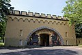
The lion gate of the former fortress of Emperor Alexander
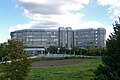
Headquarters of the Federal Archives
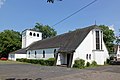
Parish Church of St. Beatus
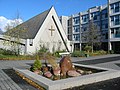
Chapel of St. Bruno

Karthaus-Flugfeld settlement area: homes with gardens, some with Mediterranean plants

The Koblenz telecommunications tower on the Kühkopf


Web links
- District newspaper "Der Karthäuser"
- POW camp on the Karthauser, around 1871
- Plan of the fortified camp beyond the Carthäuserhof near Coblentz (from 1792, not 1799, as stated in the catalog).
- Aerial photograph of the large new housing estate from the database of the LMZ Rhineland-Palatinate
- Elevated tower tank on the Karthauser (1939) from the database of the LMZ Rheinland-Pfalz
- Literature about Koblenz-Karthauser in the Rhineland-Palatinate state bibliography
literature
- Hans Bellinghausen (Ed.): 2000 years Koblenz . Boldt, Boppard 1973, ISBN 3-7646-1571-0 .
- Ulrike Weber (edit.): Cultural monuments in Rhineland-Palatinate. Monument topography Federal Republic of Germany. Volume 3.3: City of Koblenz. Districts. Werner, Worms 2013, ISBN 978-3-88462-345-9 .
Individual evidence
- ↑ Statistical Yearbook of the City of Koblenz 2014 - Small-scale structure. Pp. 0–7 ( koblenz.de PDF).
- ↑ Hans Bellinghausen: The Merkur temple in the Coblenz city forest [Part 1] . In: Koblenzer Heimatblatt . No. 47 . Koblenz November 15, 1925 ( dilibri.de ).
- ^ Hans Bellinghausen: The temple of Merkur in the Coblenz city forest [Part 2] . In: Koblenzer Heimatblatt . No. 48 . Koblenz November 22, 1925 ( dilibri.de ).
- ↑ Dieter Marcos: The monastery complex on the Beatusberg . In: Kloster-fortress, exhibition catalog of Pro Konstantin eV, September 11, 1994 . Koblenz 1994.
- ↑ Andreas Schüller: The black picture gene on the Karthaus near Coblenz . In: Koblenzer Heimatblatt . No. 22 . Koblenz August 10, 1924 ( dilibri.de ).
- ↑ Philipp Seibel: Die Karthäuser Schwarz 'Mother of God . In: From days gone by . tape 4 . Niederspay 1963, p. 17-19 .
- ↑ Tranchot von Müffling'sche Karte from 1810, published by the Land Survey Office Koblenz in 1968 on a scale of 1: 25000.
- ↑ Hans Konter: The werewolf on the Karthauser . In: From days gone by . tape 4 . Niederspay 1963, p. 21-22 .
- ^ Karl Zimmermann: Koblenz in autumn 1792 [Part 1] . In: Koblenzer Heimatblatt . No. 6 . Koblenz March 15, 1931 ( dilibri.de ).
- ^ Karl Zimmermann: Koblenz in autumn 1792 [Part 2] . In: Koblenzer Heimatblatt . No. 7 . Koblenz March 29, 1931 ( dilibri.de ).
- ^ Bellinghausen: 2000 years Koblenz. 1973, p. 286 and 379.
- ↑ Hartwig Haubrich: The greater Koblenz area in aerial photographs . Koblenz 1972, DNB 730097846 , p. 50 .
- ↑ Wolfgang Heuser: From the draw well to the waterworks. History of the drinking water supply in Koblenz . Koblenz 1995, p. 115-116, 156, 159, 162-163 . Thomas Tippach: Koblenz as a Prussian garrison and fortress city (= urban research [representations] . Volume 53 ). Cologne 2000, p. 143 . Ernst Grahn: The water supply for the city of Coblenz . Koblenz 1884, p. 35-36 ( dilibri.de ).
Coordinates: 50 ° 20 ′ 29 ″ N , 7 ° 34 ′ 7 ″ E

Old town | Arenberg | Arzheim | Asterstein | Bubenheim | Ehrenbreitstein | Gold mine | Güls | Horchheim | Horchheimer Höhe | Immendorf | Karthauser (Karthauser Nord, Karthauser Flugfeld and Karthauserhof area) | Kesselheim | Lay | Lützel | Metternich | Moselle white | Neuendorf | Niederberg | Oberwerth | Pfaffendorf | Pfaffendorfer Höhe | Rauental | Rübenach | Stolzenfels | Southern suburb ( center and south ) | Wallersheim