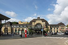
Koblenz center
| Koblenz center | |
|---|---|
| Basic data | |
| District since: | ? |
| Area : | 0.59 km² |
| Residents : | 3,619 (Sep 30, 2012) |
| Population density : | 6,086 inhabitants per km² |
| Postal code : | 56068 |
| Area code : | 0261 |
| License plate : |
KO
|
Koblenz-Mitte is a statistical district of Koblenz . Together with the south adjoining statistical district south, it forms the southern suburb . According to the recommendation of the German Association of Cities, this is subdivided into the middle and south for statistical reasons within the framework of the small-scale structure .
The southern suburb was created from 1890 in the course of the southern city expansion after the Prussian city fortifications were abandoned . The statistical district of Mitte lies between the old town (delimited: Friedrich-Ebert-Ring), Goldgrube (Bahndamm / Obere Löhrstrasse) and South (Markenbildchenweg).
Culture and sights
- Central Station
- The Rhein-Mosel-Halle is the most important event and conference location in the city of Koblenz. It was built on the site of the old Koblenz Festival Hall, which was in the immediate vicinity and which was destroyed in World War II. The building is currently (as of 2012) being renovated.
- The only remaining cinemas in the city center are in the upper Löhrstrasse .
- The baroque plague cross from 1669 in Obere Löhrstrasse.
- The Oberpostdirektion and the neo-Gothic Christ Church on Friedrich-Ebert-Ring.
- The wine village and the Königshalle on the banks of the Rhine.
- The high-rise office building (built 1927-29) in Bahnhofstrasse.
- Representative town houses on Obere Löhrstrasse and in Markenbildchenweg.
- The former Toto Lotto building on Bahnhofsplatz as a striking example of 1950s architecture.
Infrastructure
administration
The Mayen-Koblenz district administration is located in a new building on Friedrich-Ebert-Ring and Bahnhofstrasse , which was built after 1978 in place of the old district building. The high-rise office building in Bahnhofstrasse houses part of the administration of the city of Koblenz. The administrative headquarters of the Koblenz Chamber of Crafts can also be found on Friedrich-Ebert-Ring .
traffic
The Mitte district is bordered to the north by Friedrich-Ebert-Ring ( B 49 ), which is one of the main traffic axes in the city of Koblenz. Other important traffic routes to the south are Hohenzollernstrasse and Mainzer Strasse. Koblenz Central Station is in the statistical district .
church
The only church in the statistical district of Mitte is the Protestant Christ Church on Friedrich-Ebert-Ring, built in 1905 .
Kindergartens and schools
There are no fewer than three grammar schools in Koblenz in the Mitte district: the Hilda grammar school, the Max von Laue grammar school and the Bischöfliches Cusanus grammar school (former Ursuline school). In addition, the Zimmermann School of Economics is a private vocational school.
Parks and green spaces
The only contiguous green space in the city center is a section of the Rhine facilities on the banks of the Rhine. This extends from the Kaiserhalle ( Pfaffendorfer Bridge ) to Januarius-Zick-Straße.
literature
- Max Bär : From the history of the city of Koblenz. 1814-1914. Koblenz 1922.
- Energieversorgung Mittelrhein GmbH (ed.): History of the city of Koblenz . Overall editing: Ingrid Bátori in conjunction with Dieter Kerber and Hans Josef Schmidt
- Vol. 1: From the beginning to the end of the electoral era . Theiss, Stuttgart 1992. ISBN 3-8062-0876-X
- Vol. 2: From the French city to the present . Theiss, Stuttgart 1993. ISBN 3-8062-1036-5
- Herbert Dellwing (editor): Cultural monuments in Rhineland-Palatinate. Monument topography Federal Republic of Germany. Volume 3.1: City of Koblenz. Southern suburb and Oberwerth. Schwann, Düsseldorf 1986. ISBN 3-590-31033-2
- Ulrike Weber (edit.): Cultural monuments in Rhineland-Palatinate. Monument topography Federal Republic of Germany. Volume 3.3: City of Koblenz. Districts. Werner, Worms 2013, ISBN 978-3-88462-345-9 .
Web links
Individual evidence
- ↑ Yearbook of the City of Koblenz 2013 - Kleinräumige Gliederung, p. 11. Accessed on February 23, 2020 .
Coordinates: 50 ° 21 '11 " N , 7 ° 35' 43" E


