
Koblenz-South
| Koblenz-South | |
|---|---|
  |
|
| Basic data | |
| District since: | Founded in 1890 |
| Area : | 1.44 km² |
| Residents : | 6,612 (Sep 30, 2012) |
| Population density : | 4,567 inhabitants per km² |
| Postal code : | 56068 |
| Area code : | 0261 |
| License plate : |
KO
|
Koblenz-Süd is a statistical district of Koblenz . Together with the statistical district of Mitte bordering to the north, it forms the southern suburb . According to the recommendation of the German Association of Cities, this is subdivided into the middle and south for statistical reasons within the framework of the small-scale structure .
The southern suburb was created from 1890 in the course of the southern city expansion after the Prussian city fortifications were abandoned . The statistical district south, located at the foot of the Karthauses and west of the former Rheininsel Oberwerth, is characterized by the Catholic parish church of St. Josef and the Protestant monastery of St. Martin . The southern section of the Rhine facilities with the Kaiserin Augusta monument is located along the banks of the Rhine .
Buildings
- Catholic parish church of St. Joseph
- Trinity Chapel in the Laubach Valley
- Empress Augusta monument in the Rhine complex
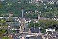
View in the Karthauser on the Catholic parish church St. Josef Südliche Vorstadt
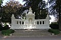
Empress Augusta monument in the Rhine complex
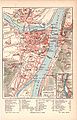
City map from 1905
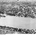
The southern suburb 1953


literature
- Max Bär : From the history of the city of Koblenz. 1814-1914. Koblenz 1922.
- Energieversorgung Mittelrhein GmbH (ed.): History of the city of Koblenz. Overall editing: Ingrid Bátori in conjunction with Dieter Kerber and Hans Josef Schmidt. Theiss, Stuttgart 1992-1993;
- Volume 1: From the beginning to the end of the electoral era. 1992, ISBN 3-8062-0876-X ;
- Volume 2: From the French city to the present. 1993, ISBN 3-8062-1036-5 .
- Herbert Dellwing (editor): Cultural monuments in Rhineland-Palatinate. Monument topography Federal Republic of Germany. Volume 3.1: City of Koblenz. Southern suburb and Oberwerth. Schwann, Düsseldorf 1986. ISBN 3-590-31033-2
- Ulrike Weber (edit.): Cultural monuments in Rhineland-Palatinate. Monument topography Federal Republic of Germany. Volume 3.3: City of Koblenz. Districts. Werner, Worms 2013, ISBN 978-3-88462-345-9 .
Web links
Individual evidence
- ↑ Yearbook of the City of Koblenz 2013 - Kleinräumige Gliederung, p. 11. Accessed on February 23, 2020 .
Coordinates: 50 ° 20 ′ 44 ″ N , 7 ° 35 ′ 26 ″ E

Old town | Arenberg | Arzheim | Asterstein | Bubenheim | Ehrenbreitstein | Gold mine | Güls | Horchheim | Horchheimer Höhe | Immendorf | Karthauser (Karthauser Nord, Karthauser Flugfeld and Karthauserhof area) | Kesselheim | Lay | Lützel | Metternich | Moselle white | Neuendorf | Niederberg | Oberwerth | Pfaffendorf | Pfaffendorfer Höhe | Rauental | Rübenach | Stolzenfels | Southern suburb ( center and south ) | Wallersheim