
Koblenz-Arzheim
|
Arzheim
City of Koblenz
Coordinates: 50 ° 21 ′ 18 ″ N , 7 ° 37 ′ 57 ″ E
|
|
|---|---|
| Area : | 4.29 km² |
| Residents : | 2173 (Sep 30, 2012) |
| Population density : | 507 inhabitants / km² |
| Incorporation : | 1970 |
| Postal code : | 56077 |
| Area code : | 0261 |
  Location of the Arzheim district
|
|
Koblenz-Arzheim is a district of Koblenz . The district, incorporated in 1970, is located on the right bank of the Rhine on a hill between the Mühlenbach in the north and the Griesentalbach in the south.
geography
The place has about 2,200 inhabitants and an area of approx. 486.7 ha (46.7 ha of which is built-up area, 13.1 ha of recreational area, 31.2 ha of traffic area, 141.9 ha of agricultural area, 191.5 ha of forest area, 1 , 9 ha of water and 60.4 ha for other uses). The highest point in Arzheim is the Steinerkopf at 233 m.
history
The presumably first, but unconfirmed, mention of Arzheim comes from the year 868. However, the area of the Arzheim district was already settled before the birth of Christ , which is proven by grave finds. Around the year 1000, the builder of Ehrenbreitstein Castle is said to have donated his farm in Arzheim to the St. Kastor monastery .
Then begins an eventful history that brings the farms and economic goods and later the village changing lords, including Hermann V. von Helfenstein and his wife Anna von Boos von Waldeck . Arzheim belonged to the family fief of the von Helfenstein family from 1300 to 1581 . During this time, today's center of Arzheim developed, which was initially around the Romanesque parish church of St. Aldegundis from around 1000. After the destruction by French troops in 1678, the place north of the church was rebuilt.
With construction of the fortress Koblenz by the early 19th century Prussia was Arzheim in the second Rayon of forts Asterstein . Thus, only half-timbered houses were allowed to be built in the place . From 1866 the Arzheimer Schanze was built on the western approach , which was completely razed in 1927 .
The place was named Arzheym as early as 1300. Until 1803 he belonged to the Electoral Trier office of Ehrenbreitstein and was assigned to the Duchy of Nassau in the Reichsdeputationshauptschluss . After the region was taken over by the Kingdom of Prussia (1815), Arzheim was assigned to the mayor's office of Ehrenbreitstein . After Ehrenbreitstein was incorporated into Koblenz in 1937, Arzheim came to the Vallendar office . Arzheim was dissolved as an independent municipality in the Koblenz district by the “ 9th State Law on Administrative Simplification” and incorporated into the city of Koblenz on November 7, 1970 with the settlement agreement of November 2, 1970.
politics
Local advisory board
A local district was formed for the Arzheim district . The local advisory board consists of nine advisory board members, the chair of the local advisory board is chaired by the directly elected mayor.
For the composition of the local council, see the results of the local elections in Koblenz .
Mayor
The mayor is Wolfram Wilde (CDU). In the direct election on May 26, 2019, he was elected with 84.50% of the vote and is the successor to Josef Kraemer (CDU), who did not run again after 20 years in office.
Buildings
- Catholic parish church of St. Aldegundis
- Chapel to the mother of beautiful love
- Arzheimer Schanze

Aerial photo of Arzheim 2007
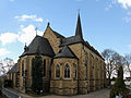
The Catholic parish church of St. Aldegundis

Remains of the Arzheimer Schanze


coat of arms
 |
Blazon : “The coat of arms is shown as a triangular shield. It has a black shield head (crossbar) and is divided by a black shield main strip post (Frankenpfahl) that extends to the base of the shield.
The following family coats of arms are placed in the fields of the divided triangular shield with a black border:
|
|
Justification of the coat of arms: The coat of arms in the form of a divided triangular shield with the head of the shield and the Franconian post is derived from a seal from 1406 that has been preserved. In this seal is the portrait of the parish patron saint, St. Aldegundis depicted. The fields of the divided triangular sign were previously empty.
Following on from the more than 1000-year history of the village of Arzheim, which was independent until 1970, the coats of arms inserted in front / left and back / right remind of the former village lord, Hermann V. von Helfenstein and his wife Anna von Boos von Waldeck, the one in the middle of the 15th century in and around Arzheim exercised the basic rights and sovereignty (high jurisdiction). |
literature
- Ulrike Weber (edit.): City of Koblenz - city districts (= cultural monuments in Rhineland-Palatinate. Monument topography Federal Republic of Germany . Volume 3.3 ). Wernersche Verlagsgesellschaft, Worms 2013, ISBN 978-3-88462-345-9 .
- Literature about Koblenz-Arzheim in the Rhineland-Palatinate state bibliography
Web links
- Historical information about Arzheim on regionalgeschichte.net
- Short portrait of Arzheim with a film on SWR television
- Private website about Koblenz-Arzheim
- online ; Rheinischer Antiquarius about Arzheim: Abt. 2, Vol. 2, S. 301, S. 411-432 (Chapter Der Mühlengrund, Arzheim, die Blind. ), 1850s
Individual evidence
- ↑ Official municipality directory (= State Statistical Office of Rhineland-Palatinate [Hrsg.]: Statistical volumes . Volume 407 ). Bad Ems February 2016, p. 153 (PDF; 2.8 MB).
- ^ City of Koblenz: main statute. (PDF) § 9 to July 11, 2019, accessed on October 20, 2019 .
- ^ City of Koblenz: Arzheim Mayor 2019. Accessed on October 20, 2019 .
- ↑ Katrin Steinert: Down-to-earth and committed: Wolfram Wilde wants to become local manager of Arzheim. Rhein-Zeitung Koblenz, May 15, 2019, accessed on October 20, 2019 .

Old town | Arenberg | Arzheim | Asterstein | Bubenheim | Ehrenbreitstein | Gold mine | Güls | Horchheim | Horchheimer Höhe | Immendorf | Karthauser (Karthauser Nord, Karthauser Flugfeld and Karthauserhof area) | Kesselheim | Lay | Lützel | Metternich | Moselle white | Neuendorf | Niederberg | Oberwerth | Pfaffendorf | Pfaffendorfer Höhe | Rauental | Rübenach | Stolzenfels | Southern suburb ( center and south ) | Wallersheim