
Koblenz-southern suburb
| Southern suburb | |
|---|---|
  |
|
| Basic data | |
| District since: | Founded in 1890 |
| Area : | 2.03 km² |
| Residents : | 10,231 (Sep 30, 2012) |
| Population density : | 5040 inhabitants per km² |
| Postal code : | 56068/56075 |
| Area code : | 0261 |
| License plate : |
KO
|
Koblenz-Südliche Vorstadt is a district of Koblenz . It was created from 1890 in the course of the southern expansion of the city after the Prussian city fortifications were abandoned . Today the district is a dense residential area, which lies at the foot of the Karthause and west of the former Rhine island of Oberwerth. It is shaped by the Catholic parish church of St. Josef , the main train station and the Protestant monastery St. Martin . The southern section of the Rhine facilities with the Kaiserin Augusta monument is located along the banks of the Rhine .
The southern suburb is subdivided into the middle and the south for statistical reasons as part of the small-scale breakdown according to the recommendation of the German Association of Cities .
geography
The southern suburb is east of the Karthaus , which lies on a ridge that forms the northernmost foothills of the Hunsrück . Directly in front of this slope the left-hand Rhine stretch runs in a north-south direction . In the north, the district is bounded by Friedrich-Ebert-Ring, which forms the border with the old town , and in the east by the Rhine . In the south lies the Laubach , which closed off the urban area until the incorporation of Stolzenfels in 1969.
history


After Prussia took over Koblenz in 1816 , the city was heavily fortified. With the construction of the Koblenz Fortress , the city fortifications were rebuilt . A mighty rampart surrounding the city ran along today's Moselring and Friedrich-Ebert-Ring roads. Even after the founding of the empire in 1871 and a considerable increase in population, the settlement area could not be expanded, as in other German cities. The reason was the building restriction due to the requirements of the Reichsrayon Act initiated by Prussia . Building within the 1st Rayon up to 600 m in front of the ramparts was completely forbidden and in the 2nd Rayon (the next 375 m) only easily demolished low half-timbered houses were allowed.
In the 17th and 18th centuries there were some gardens and mills in the area of today's southern suburb . From one of these mills on Laubach, the Bad Laubach cold water sanatorium was built in 1840–1843 and the Trinity Chapel, which still exists today, for spa guests from 1847–1848 .
The Markenbildchen chapel was inaugurated on July 2, 1851 at today's intersection of Markenbildchenweg and Hohenzollernstrasse . After the war destruction in 1944, the miraculous image that was erected there around 1720 was brought to the parish church of St. Joseph. With the extension of the left Rhine route from Koblenz to Bingerbrück in 1859 and the opening of the Moselle route in 1879 , a freight station (Moselbahnhof) was built a little north of today's main station in the same year . Since the Horchheimer railway bridge was built in 1876–1878, there was also a connection in the southern area via the then Rhine island of Oberwerth to the right-hand Rhine route . The Prussian Princess Augusta had the banks of the Rhine between Oberwerth and the Electoral Palace designed into a landscape garden from 1856–1861, and the Empress Augusta grounds named after her in 1891 .
The early road network of the 19th century was the basis for the later development of the southern suburb, which the city of Koblenz aimed to achieve from 1875. For this purpose, the district master builder Zweck developed a development plan for the 2nd Rayon, which was approved by the City Council on June 22, 1878. After that, many of today's major streets were laid out in the district. In the 1870s and 1880s a number of houses were built in the 2nd Rayon and despite the prohibition, but with special permission, even in the 1st Rayon. The Koblenz Fortress was classified as of minor importance from 1886. When Mayor Emil Schüller took office in 1888, he vehemently advocated the abandonment of the city fortifications by the Prussian government. In a cabinet order of March 13, 1890, the latter ordered the long-awaited abandonment of the city fortifications and sold the area to the city. Shortly before, the city had already commissioned the important Prussian town planner Josef Stübben to draw up a plan for the expansion of the town. His plan envisaged an expansion of the city of Koblenz to the west ( gold mine , Rauental ) and south (southern suburb). Large parts of his plan, especially the generous traffic axes in the west, were not implemented. Just one year later it was revised by Otto Theodor Amandus Fohl (1834-1897) and replaced by his simplified plan, the "Overview map of the city of Coblenz - draft of the southern part of the city expansion" (see plan from 1889/1890). Then the city bought the former military area of the city fortifications until 1896.
After the Prussian city fortifications were torn down, two large rings were built in place of the wall, the Kaiserin-Augusta-Ring (today Moselring) and the Kaiser-Wilhelm-Ring (today Friedrich-Ebert-Ring). The Catholic Church of the Sacred Heart of Jesus was built in the neo-Romanesque style directly at the former Löhrtor from 1900 to 1903 according to plans by the later Mainz cathedral master builder Ludwig Becker . A new settlement area quickly grew south of the former ramparts. Around the Catholic St. Joseph Church , built in 1897, and the city's first new Protestant church, the Christ Church , built in 1904 , ornate town houses from the Wilhelminian era were built . Rich citizens built representative villas along the banks of the Rhine. The municipal festival hall was built on the east wing of the former Mainz Gate from 1898 to 1901 . The small Rheinbahnhof in Fischelstrasse was abandoned and a splendid main station was built in the new southern suburb from 1899 to 1902 according to plans by Fritz Klingholz instead of the Moselle station . Other important secular buildings were the Oberpostdirektion (1905–1907) on Kaiser-Wilhelm-Ring and the Police Directorate (1912–1913) and the main building of the Kreissparkasse Koblenz (1912–1913) in Bahnhofstrasse .


Up until the First World War , however, there was only some areas of dense development. In the 1920s, during the Allied occupation of the Rhineland and the resulting housing shortage, additional residential buildings were built. In 1924 a competition was held to redesign the northeastern station forecourt. To this end, the city's first high-rise was built between 1927 and 1928 , and today it houses the technical town hall (building and civil engineering office). In 1925 the Reich Exhibition of German Wine took place in Koblenz . For this purpose, an event area was created between the municipal festival hall and the Rhine facilities with the still (smaller) wine village that has been preserved to this day.
During the Second World War , the southern suburb suffered extensive damage in the air raids on Koblenz . Many of the buildings mentioned above were destroyed and only simplified or not rebuilt at all. In the 1950s, the old structure was partially replaced by spacious residential complexes for the French occupation army . The destroyed municipal festival hall was replaced in 1959–1962 a few meters behind it by the Rhein-Mosel-Halle . After that, in the early 1960s, the Pfaffendorfer Bridge could be connected to the Friedrich-Ebert-Ring without crossing. In the 1970s and 1980s, many buildings that had become victims of speculation were demolished . In the course of the expansion of the B 9 , 29 houses along Römerstrasse and Karthäuserstrasse had to be demolished in the 1990s. The station square was completely redesigned in 1998-2000. The parking spaces were moved to an underground car park under the square and a spacious bus station and a pavilion with shops were built on the square itself . Until 2005 the station building was rebuilt and modernized at the same time.
Culture and sights
Churches and monasteries
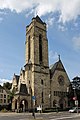
- Catholic parish church of St. Joseph
- Evangelical Christ Church
- Trinity Chapel
- Former convent of the Sisters of the Holy Spirit
- Baroque plague cross from 1669 in the upper Löhrstrasse
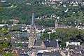
Catholic parish church of St. Joseph
Evangelical Christ Church

Plague cross from 1669


Secular buildings
- Central Station
- The Rhein-Mosel-Halle is the most important event and conference location in the city of Koblenz. It was built on the site of the old town festival hall in the immediate vicinity, which was destroyed in the Second World War.
- The only remaining cinemas in the city center are in the upper Löhrstrasse .
- The wine village , the wine fountain and the king's hall in the Rheinanlagen.
- The high-rise office building (built 1927-28) in Bahnhofstrasse.
- Representative town houses on Obere Löhrstrasse and in Markenbildchenweg.
- The former Toto Lotto house on Bahnhofsplatz as a striking example of 1950s architecture.
- Prussian milestone on Mainzer Strasse.

Wine village in the Rhine plants

Upper bourgeois row house on Kurfürstenstrasse


Monuments

- Empress Augusta Monument
- Monument to Fritz Michel
Parks
- The Kaiserin Augusta facilities as part of the Rhine facilities
traffic
The Südliche Vorstadt district is bordered to the north by Friedrich-Ebert-Ring ( B 49 ), which is one of the main traffic axes in the city of Koblenz. Other important traffic routes to the south are Hohenzollernstrasse and Mainzer Strasse. The district is bounded to the west by the city's most important north-south axis, the B 9 . The left-hand Rhine route with Koblenz main station runs right next to it . At the southern end in Schützenstrasse is the depot with administration building of evm Verkehrs GmbH (formerly KEVAG ), which operates the public transport in Koblenz.
literature
- Max Bär: From the history of the city of Koblenz. 1814-1914 . Koblenz 1922.
- Energieversorgung Mittelrhein GmbH (ed.): History of the city of Koblenz . Overall editing: Ingrid Bátori in conjunction with Dieter Kerber and Hans Josef Schmidt
- Vol. 1: From the beginning to the end of the electoral era . Theiss, Stuttgart 1992. ISBN 3-8062-0876-X
- Vol. 2: From the French city to the present . Theiss, Stuttgart 1993. ISBN 3-8062-1036-5
- Reinhard Kallenbach : Koblenz's story retold. Mittelrhein Verlag, Koblenz, 2012, ISBN 978-3-925180-03-3
- Herbert Dellwing (editor): Cultural monuments in Rhineland-Palatinate. Monument topography Federal Republic of Germany. Volume 3.1: City of Koblenz. Southern suburb and Oberwerth. Schwann, Düsseldorf 1986. ISBN 3-590-31033-2
- Ulrike Weber (edit.): Cultural monuments in Rhineland-Palatinate. Monument topography Federal Republic of Germany. Volume 3.3: City of Koblenz. Districts. Werner, Worms 2013, ISBN 978-3-88462-345-9 .
Web links
- Koblenz city history - Part 36: Koblenz people fight for city expansion in: Rhein-Zeitung , July 20, 2012
- Koblenz city history - Part 40: Koblenz Fortress - The shackles fall in: Rhein-Zeitung , July 20, 2012
- 11. Softening 11.1 The time of the city expansion in: garwainkoblenz.de
- Birgitta Gruber: City expansion in the Rhineland. Commune, citizens and the state as actors in the development process of Bonn's Südstadt from 1855 to 1890. Dissertation, Bonn 2001
Individual evidence
- ↑ Statistical Yearbook of the City of Koblenz 2014 - Kleinräumige Gliederung, pp. 0–7
- ↑ Law on Restrictions on Real Estate Around Fortresses
- ↑ The brand image in the St. Josefskirche Koblenz ( Memento from November 11, 2014 in the Internet Archive )
Coordinates: 50 ° 21 ′ 0 ″ N , 7 ° 35 ′ 38 ″ E

Old town | Arenberg | Arzheim | Asterstein | Bubenheim | Ehrenbreitstein | Gold mine | Güls | Horchheim | Horchheimer Höhe | Immendorf | Karthauser (Karthauser Nord, Karthauser Flugfeld and Karthauserhof area) | Kesselheim | Lay | Lützel | Metternich | Moselle white | Neuendorf | Niederberg | Oberwerth | Pfaffendorf | Pfaffendorfer Höhe | Rauental | Rübenach | Stolzenfels | Southern suburb ( center and south ) | Wallersheim