
Koblenz gold mine
| Koblenz gold mine | |
|---|---|
  |
|
| Basic data | |
| District since: | Founded around 1920 |
| Area : | 1.09 km² |
| Residents : | 4,300 (Sep 30, 2012) |
| Population density : | 3929 inhabitants per km² |
| Postal code : | 56073 |
| Area code : | 0261 |
| License plate : |
KO
|
Koblenz-Goldgrube is a centrally located district of Koblenz . It is located between the Karthauser and the Moselle railway line Koblenz – Trier, only a few minutes' walk from the center of Koblenz. In addition to a residential area, there is the Brüderhaus St. Josef hospital , a retirement home , the Beatusbad and three schools . The main cemetery in Koblenz is located in the gold mine on the slope of the Karthauser .
history
The name of the district comes from an old field name (Unter den Goldgruben), which was first mentioned in 1397. It was derived from the fertile fields and vineyards in the slight depression that reached as far as the white of the Moselle . In the late Roman and Franconian times, however, one can already assume that the area was used for agriculture. The free area at the gates of Koblenz was suitable both as a deployment area and for defense in the many wars to which the city was exposed due to its strategic location. Today's main cemetery was built on the slope of the Karthaus from 1820 and was expanded further in the period that followed.
The gold mine was uninhabited until the end of the 19th century. It was only when the Prussian fortress Koblenz was abandoned in 1890 that permanent houses could also be built outside the city fortifications . The construction of the first building began in 1898, so in 1899 the St. Josef Brothers House , in 1903 the Thielenschule (1903–1909 Catholic teachers' college, from 1909 elementary school) and in 1908 the neo-baroque orphanage (today the St. Barbara home for the elderly) was completed. A first zoning plan was drawn up by the city of Koblenz in 1902, but it was not implemented until the First World War . A few stonemasons and gardeners then settled along Beatusstrasse in front of the main cemetery. The first rows of houses were not built around today's Overbergplatz for employees of the railway, police, post office and city administration until the 1920s. This was followed by the construction of further apartment blocks and commercial areas in the gold mine.
During the Second World War , the neighboring goods station Koblenz-Mosel was often the target of air raids on Koblenz . The bombs devastated a large part of the still young part of the city. During the British attack on November 6, 1944, a Lancaster bomber with an eight-man crew hit what is now Johannes-Junglas-Strasse. Most of the reconstruction was completed by the end of the 1950s. On October 4, 1969, the Catholic parish church of St. Franziskus was inaugurated on Overbergplatz . The Beatusbad in the gold mine was opened in 1975.
Attractions
-
Main cemetery , the largest cemetery in Koblenz and landscape park
- Napoleonstein , memorial to the German veterans of Napoleon's army
- Battery Hübeling , place of honor of the city of Koblenz for the fallen of the Second World War with a hall of honor
- Catholic parish church of St. Francis
- Brüderhaus St. Josef , hospital in the Catholic Clinic Koblenz-Montabaur

Cemetery cross in the main cemetery
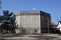
The Catholic Parish Church of St. Francis

The former orphanage St. Barbara (today dormitory)


traffic
The construction of a new train stop is planned on the Moselle route between Rauental and Goldgrube (near Follmannstrasse). A pedestrian overpass is also being considered, with which Goldgrube and Rauental could be better connected.
literature
- Ulrike Weber (edit.): Cultural monuments in Rhineland-Palatinate. Monument topography Federal Republic of Germany. Volume 3.3: City of Koblenz. Districts. Werner, Worms 2013, ISBN 978-3-88462-345-9 .
Web links
- District portal of the Koblenz gold mine
- Historical information on the gold mine in: regionalgeschichte.net
Individual evidence
- ↑ Horchheim, Goldgrube, Bendorf: New train stops are planned rhein-zeitung.de, July 26, 2016, accessed on September 23, 2016
Coordinates: 50 ° 21 ′ 16 ″ N , 7 ° 34 ′ 40 ″ E

Old town | Arenberg | Arzheim | Asterstein | Bubenheim | Ehrenbreitstein | Gold mine | Güls | Horchheim | Horchheimer Höhe | Immendorf | Karthauser (Karthauser Nord, Karthauser Flugfeld and Karthauserhof area) | Kesselheim | Lay | Lützel | Metternich | Moselle white | Neuendorf | Niederberg | Oberwerth | Pfaffendorf | Pfaffendorfer Höhe | Rauental | Rübenach | Stolzenfels | Southern suburb ( center and south ) | Wallersheim