
Koblenz-Ehrenbreitstein
| Koblenz-Ehrenbreitstein | |
|---|---|
  |
|
| Basic data | |
| District since: | 1937 |
| Area : | 1.71 km² |
| Residents : | 1,993 (Sep 30, 2012) |
| Population density : | 1,168 inhabitants per km² |
| Postal code : | 56077 |
| Area code : | 0261 |
| License plate : |
KO
|

Koblenz-Ehrenbreitstein is a district of Koblenz . It is on the right bank of the Rhine opposite the Deutsches Eck . The formerly independent city was incorporated into Koblenz in 1937. In the 17th century, the Electors of Trier made Ehrenbreitstein their residence. The Ehrenbreitstein Fortress is located above the village on the mountain of the same name . The old town of Ehrenbreitstein has been part of the Upper Middle Rhine Valley UNESCO World Heritage Site since 2002 .

geography
The area within the Ehrenbreitstein district is characterized by extreme differences in altitude. While the settlement area of the village is in a valley at the level of the Rhine, it is bordered by high slopes in the north and east. In the north rises the 114 m high and steeply rising rock spur Ehrenbreitstein, on whose plateau the Ehrenbreitstein Fortress sits enthroned. The Ehrenbreitstein valley was formerly traversed by two brooks, the Mühlenbach and the Arzheimer Bach (also called Blindbach or Griesentalbach), but both of them were channeled under the city towards the Rhine in the 19th century.
history
Early history
The Ehenbreitstein plateau has been around since 1000 BC. Attached. The continuous fortification of a place over such a long period of time could not be proven anywhere else in Germany. On the southern rock spur there was a late Roman burgus from around 250 to 450 to protect the mouth of the Moselle, the Roman roads and the nearby Limes . A Roman road led from the Ehrenbreitstein valley to the Niederberg fort and further into the Westerwald . A Roman pile bridge was built over the Rhine in AD 49 from today's Kapuzinerplatz on the Ehrenbreitsteiner side to Kastel Koblenz .
Ehrenbreitstein Castle / Fortress

A castle was first mentioned around 1000 on the Ehrenbreitstein , which was built by an Erembert or Ehrenbrecht from a Konradinian house . In 1020 it became the property of the Archbishops of Trier . It was their bridgehead for the electorate's property on the right bank of the Rhine and was considered their safest castle. Archbishop Hillin von Fallemanien had this castle expanded from 1160 onwards. Helfenstein Castle was built on the south side . The Lords of Helfenstein resided here from the 12th to the 14th century . Elector Richard von Greiffenklau had the castle expanded into a fortress at the beginning of the 16th century . In 1524 he had the nine-ton Greif cannon cast in Frankfurt and erected on the Ehrenbreitstein.
Place name
A settlement in Ehrenbreitstein was first mentioned in 1211, when half of a mill called "villa Mulne sub Herinbrechtstein" was donated to the Benedictine monastery on the Oberwerth . The name of the settlement changed from 1235 Mulenheim, 1284 Mulinheym, 1304 Molin, 1411 Mulen under Helfenstein to 1532 Mühlheim im Thal. In 1355 the name Tal was used for the place, also written Dail or 1459 Dael. Elector Philipp Christoph von Sötern had the place officially named Philippstal with the construction of Philippsburg Palace . During the Thirty Years War , however, the name Ehrenbreitstein became common.
Electoral residence and monasteries

Around the year 1493, Johannes von Paltz founded an Augustinian monastery in Ehrenbreitstein . He was theology professor and teacher of Martin Luther , who is said to have visited him on his trip to Rome in 1510 in Ehrenbreitstein. The monastery was dissolved again in 1573.
Below the fortress, Elector Philipp Christoph von Sötern built Philippsburg Palace from 1626 to 1632 and moved his residence here from Trier, which has since become unsafe . At his personal request, the Capuchins settled in Ehrenbreitstein in 1627 and built a monastery . During the Thirty Years' War Ehrenbreitstein was devastated in 1636 when there was tough fighting between imperial troops over the fortress above the city and occupied by the French.
The subsequent electors kept Philippsburg Palace as their residence. In the following years important impulses for the political and cultural life of Kurtrier came from here. Immediately at the entrance to the castle, under Elector Franz Georg von Schönborn, a castle-like building was built between 1738 and 1749, the so-called Dicastery building (see Dicastery ) to accommodate the Electorate Central Administration according to plans by Balthasar Neumann . At the same time, the Krummstall was built behind the dicastery building to accommodate soldiers, staff and workshops. In addition to the dicastery building, Johannes Seiz built the stables in 1762 . In 1672 the place received its first city fortification in the form of a curtain wall . The time as electoral residence ended when elector Clemens Wenzeslaus of Saxony no longer wanted to live in Philippsburg Palace due to the poor quality of living and moved to the newly built electoral palace in Koblenz in 1786 . Almost the entire population of Ehrenbreitstein followed him.
French and Prussians

After French troops had conquered Koblenz in 1794, they besieged the fortress until it was surrendered without a fight in 1799. The fortress was blown up in 1801 because the French had to vacate the areas on the right bank of the Rhine in the Peace of Lunéville . The Philippsburg Castle below was so damaged by the demolition that it had to be demolished.
Ehrenbreitstein then came first to the Duchy of Nassau and finally to Prussia in 1815 through the Reichsdeputationshauptschluss . From 1803 to 1815, Ehrenbreitstein was the administrative seat of a government district in Nassau . The Prussian military rebuilt Ehrenbreitstein Fortress as part of the construction of the Koblenz Fortress from 1817 to 1828. Ehrenbreitstein became a Prussian garrison town, the remaining buildings of the electoral residence housed the Münz barracks , and the Capuchin monastery temporarily became a traindepot. The city fortifications were also expanded by the Prussians until the middle of the 19th century, but were given up again in 1890. With the rebuilding of the Prussian fortress Ehrenbreitstein, the ship bridge built in 1819 created a new Rhine crossing from Ehrenbreitstein to Koblenz and replaced the flying bridge that had been in service since 1680 . It connected both sides until it was destroyed in 1945.
Further development
Shortly after the site of Philippsburg Castle was cleared, a road was built along the Rhine to Vallendar (today the B 42 ). In 1869, the construction of the right-hand Rhine route followed , which cut off the town from the Rhine. Until it was incorporated into Koblenz on July 1, 1937, the place was the administrative seat for the (Prussian) mayor's office in the Koblenz-Land district of Ehrenbreitstein, to which Arenberg , Arzheim , Horchheim , Immendorf , Pfaffendorf and Urbar also belonged. During the air raids on Koblenz in World War II, the city of Ehrenbreitstein suffered only comparatively minor damage. The Holy Cross Church , completed in 1707, was completely destroyed, as was the house in which Sophie von La Roche had lived and had her literary salon.
The renovation of the historic town center began in the 1970s and was not completed until 2014. This redevelopment brought a considerable improvement for the district and its architectural monuments, even if some historic town houses, which were already badly dilapidated, had to be demolished. From 1979 to 1982 the Koblenz Rhine culvert was built, which leads from the Rhine facilities at the level of the gauge house to Ehrenbreitstein and which reorganized the drinking water supply and drainage. In addition to the Martin-Gropius-Bau , a drinking water pumping station was built in 1983–1985. After the 450 m long "Monika" tunnel was driven into the mountain under the Ehrenbreitstein fortress in 1983 , the Mühlbach was relocated. The historic core of Ehrenbreitstein was declared a monument zone in 1998 , although at that time the place was still the largest redevelopment area in Rhineland-Palatinate.
In the years 1997 to 2003 Ehrenbreitstein was equipped with flood protection. For this purpose, a rain retention basin and a flood pumping station were built between 1997 and 1999 across from Kapuzinerplatz . The construction of the flood protection wall along the railway embankment followed until 2002. At the same time, until 2005 the route of the B 42 was laid as an elevated road parallel to the railway line and the town center was traffic-calmed . After that, the old route along Hofstrasse and Kapuzinerplatz could be redesigned up to the 2011 Federal Garden Show .
Federal Garden Show 2011

The city of Koblenz was awarded the contract to host the 2011 Federal Horticultural Show. The area in front of the fortress, a landscape park was created here, and the fortress itself was used as a venue. To this end, the state of Rhineland-Palatinate has completely renovated the fortifications. Since then, a cable car has been transporting visitors from the Rhine facilities across the Rhine to the plateau in front of the fortress.
The Ehrenbreitstein Rhine facilities were also redesigned. This created a coherent green area. The aim is to maintain a tree-covered park in the long term . The embankments were revised and new fishing spots were built. The existing children's playground was built on two levels and a total of approx. 400 m² of play area was maintained. Play equipment based on motifs from inland navigation was manufactured as special constructions for this purpose.
Attractions
- Ehrenbreitstein Fortress
- Electoral residence
- Capuchin monastery Koblenz
- Konradhaus Koblenz
- Holy Cross Church
- Heribert Tower
- Klausenberg Chapel
- Martin-Gropius-Bau , built in 1878 by Martin Gropius and Heino Schmieden as a Prussian hospital.
- Cluj-Napoca
- Luisenturm
- Rheinburg
- Birthplace of Beethoven's mother
- Dähler Born
See also: List of cultural monuments in Koblenz-Ehrenbreitstein
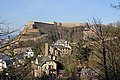
The Klausenburg (left) and the Rheinburg (right), in the background the Ehrenbreitstein Fortress

The water level well on Kapuzinerplatz shows the highest water levels in the Rhine


.JPG)
traffic

The Ehrenbreitstein district is located on the B 42 and the right-hand Rhine route with the Koblenz-Ehrenbreitstein train station . Here the trains of the RB 27 run every hour from Koblenz Hbf via Bonn-Beuel , Cologne / Bonn Airport and Cologne to Mönchengladbach . Both traffic routes separate the town from the banks of the Rhine. In place of the former ship bridge , the “Schängel” passenger ferry crosses the river today . The Ehrenbreitstein inclined elevator has been connecting the Ehrenbreitstein Valley with the east side of the Ehrenbreitstein Fortress since 2011. The Ehrenbreitstein chairlift , which ceased operations at the end of 2009 , had previously operated at the same location for 53 years . Since the Federal Garden Show, a cable car has been running across the Rhine from the Rhine facilities to the plateau in front of the Ehrenbreitstein Fortress. UNESCO decided on June 19, 2013 at the 37th session of the World Heritage Committee in Phnom Penh to allow the cable car to operate until 2026. Then the technically longest possible operating time ends.
Personalities

The following personalities were born in Ehrenbreitstein:
- 1735: Johann Matthias Carrich , Jesuit
- 1746: Maria Magdalena Keverich , mother of Ludwig van Beethoven
- 1747: Benedikt Beckenkamp , painter
- 1756: Joseph Marius von Babo , writer
- 1766: Wilhelm von Metzen , highly decorated officer in the Bavarian Army
- 1768: Franz Joseph Manskirsch , portrait and landscape painter
- 1773: Johann Anton Friedrich Reil , German-Austrian actor and writer
- 1775: Clemens Wenzeslaus Coudray , architect
- 1775: Georg Brentano , wholesale merchant
- 1777: Abundius Maehler , Lord Mayor of Koblenz from 1818 to 1847
- 1778: Clemens Brentano , writer
- 1800: Carl Josef Holzer , Roman Catholic clergyman and politician
- 1805: Gottlieb Gassen , painter
- 1850: Paula Reinhard , co-founder of the Bethlehem Monastery
- 1870: Carl Mengelkoch , Reich judge
- 1895: Carl Clemens Bücker , aircraft designer
- 1903: Joseph Breitbach , writer
- 1919: Max Jacoby , photographer
- 1923: Jürgen von Manger , actor and cabaret artist
literature
- The historical development of Ehrenbreitstein . Baukunst Verlag, Düsseldorf 1931 ( digitized version )
- Joachim J. Kneis: Koblenz-Ehrenbreitstein. A guide through the former royal seat. Koblenz 2006, ISBN 978-3-936436-08-2
- Klaus Künzel: To dust off treasure chests. Koblenz-Ehrenbreitstein. Chapter in Swallowed Cities. Ten walks through very special parts of the city. Hamburg 2013, ISBN 978-3-8491-8363-9
- Ulrike Weber (edit.): Cultural monuments in Rhineland-Palatinate. Monument topography Federal Republic of Germany. Volume 3.3: City of Koblenz. Districts. Werner, Worms 2013, ISBN 978-3-88462-345-9 .
Web links
- Private homepage to Ehrenbreitstein
- Image by Ehrenbreitstein from JF Dielmann, A. Fay, J. Becker (draftsman): FC Vogel's Panorama of the Rhine, images of the right and left banks of the Rhine, FC Vogel lithographic institution, Frankfurt 1833
- Historical information about Ehrenbreitstein in: regionalgeschichte.net
- Literature on Koblenz-Ehrenbreitstein in the Rhineland-Palatinate State Bibliography
Individual evidence
- ↑ A mountain in transition - 3000 years of fortified place in: diefestungehrenbreitstein.de
- ↑ Koblenz: Ehrenbreitsteiners celebrate the completion of the renovation in: Rhein-Zeitung , July 23, 2014
- ↑ Doppelmayr is building one of the largest cable cars in Europe over the Rhine to the Buga in Koblenz. In: Rhein-Zeitung , November 27, 2008
- ↑ Rhein-Seilbahn may stay until 2026 in: Frankfurter Allgemeine Zeitung , June 19, 2013
Coordinates: 50 ° 21 ′ 37 ″ N , 7 ° 36 ′ 54 ″ E

Old town | Arenberg | Arzheim | Asterstein | Bubenheim | Ehrenbreitstein | Gold mine | Güls | Horchheim | Horchheimer Höhe | Immendorf | Karthauser (Karthauser Nord, Karthauser Flugfeld and Karthauserhof area) | Kesselheim | Lay | Lützel | Metternich | Moselle white | Neuendorf | Niederberg | Oberwerth | Pfaffendorf | Pfaffendorfer Höhe | Rauental | Rübenach | Stolzenfels | Southern suburb ( center and south ) | Wallersheim