
Sankt Goar
| coat of arms | Germany map | |
|---|---|---|

|
Coordinates: 50 ° 9 ' N , 7 ° 43' E |
|
| Basic data | ||
| State : | Rhineland-Palatinate | |
| County : | Rhein-Hunsrück district | |
| Association municipality : | Hunsrück-Middle Rhine | |
| Height : | 74 m above sea level NHN | |
| Area : | 23.04 km 2 | |
| Residents: | 2779 (Dec. 31, 2019) | |
| Population density : | 121 inhabitants per km 2 | |
| Postal code : | 56329 | |
| Area code : | 06741 | |
| License plate : | SIM, GOA | |
| Community key : | 07 1 40 133 | |
| LOCODE : | DE 83J | |
| City structure: | 3 districts | |
City administration address : |
Heerstrasse 130 56329 Sankt Goar |
|
| Website : | ||
| City Mayor : | Falko Hönisch ( SPD ) | |
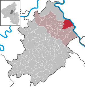
| Location of the city of Sankt Goar in the Rhein-Hunsrück district | ||
  |
||


Sankt Goar (abbreviated: St. Goar ) is a town in the Rhein-Hunsrück district in Rhineland-Palatinate on the left bank of the Middle Rhine . It belongs to the Hunsrück-Mittelrhein community .
Sankt Goar is known for its central location in the UNESCO World Heritage Upper Middle Rhine Valley , which was added to the list of World Heritage Sites in July 2002. Above the city is the ruin of Rheinfels Castle , opposite is the sister city of Sankt Goarshausen with the castles Katz and Maus . The Loreley rock is located in the immediate vicinity of the city upstream on the other side of the Rhine.
geography
Geographical location
Sankt Goar is located in the Middle Rhine Valley , the narrow breakthrough valley of the Rhine through the Rhenish Slate Mountains . The valley on the left bank of the Rhine belongs to the Hunsrück , the valley on the right bank of the Rhine belongs to the Taunus . The characteristically narrow shape of the valley originated from deep erosion of the river into a rising floe.
The next larger cities are Koblenz , as the crow flies about 24 km north and Bingen am Rhein , as the crow flies about 25 km southeast. Sankt Goar is connected by the Loreley ferry to the sister city of Sankt Goarshausen, which is directly opposite, on the right bank of the Rhine. The Rhine is about 250 meters wide here.
In Sankt Goar, the Gründelbach coming from the Hunsrück flows into the Rhine.
City structure
The city consists of the core town of Sankt Goar on the Rhine, the high-altitude districts of Biebernheim and Werlau , the Fellen district to the north on the Rhine and the An der Loreley district to the south on the Rhine .
history
Surname

The area around the future city of Sankt Goar was already settled in Roman times. The early medieval name was Wochara, named after the short stream that flows into the Rhine here.
The current name of the city goes back to the holy Goar , who settled on the site of the later city during the reign of the Frankish King Childebert I (511-538). Goar came as a young priest (monk) from Aquitaine (south-west France) and initially lived as a hermit in a rock cave on the Rhine. With the permission of the Bishop of Trier, he worked as a missionary to the rural population. He became known for his great hospitality, especially towards the Rhine boatmen. Later he built a hospice and a chapel on the site of today's town . Numerous legends have grown up around his figure. After his death around 575, Goar's grave became a place of pilgrimage and the place was named after him. Frankish King Pippin the Younger transferred the hospice and the chapel to the abbot of the Benedictine abbey of Prüm in 765 as a personal benefit . This gave rise to the canons of Sankt Goar , attested to at the end of the 11th century .
But there is another explanation for the origin of the place name.
“In the meantime, others wanted to claim that other writers as well as ancient documents show how this place was initially called Sanctgoar, but SANDGEWEHR or SANTGEWER. This name is also said to have its natural origin from the waterfall of Werb, which is very close by, or, as it was said of it, of the trade. Because because a lot of sand is thrown ashore in the surrounding areas from this commercial or trade, it should not be regarded as anything other than a real SANGGEWERRE, and so I communicated the name to the city. "
middle Ages
In 1183 St. Goar received city rights. From 1190 the city was under military protection and the jurisdiction of the Count House von Katzenelnbogen , the monastery bailiffs who had acquired the property. 1245 Built Count Diether V of Katzenelnbogen the Rheinfels Castle . With the death of the last Count of Katzenelnbogen, Philip the Elder , the County of Katzenelnbogen and thus Sankt Goar fell to the Landgraviate of Hesse in 1479 .
Hesse and French times until 1815


On November 1, 1527, Adam Krafft , who later became professor of theology, began to introduce the Reformation on behalf of the Hessian landgrave Philip I. In 1567, after the death of Philip I, the Landgraviate of Hessen was divided among his four sons. The youngest son, Philip II , received the Niedergrafschaft Katzenelnbogen, now called Hessen-Rheinfels , and with it the castle and town.
In 1580 175 people fell victim to the plague in Sankt Goar; only 18 years later, in 1598, again 142. In the plague year of 1598, Franz Schmoll built the Rheinfels pharmacy in St. Goar as the third pharmacy in Hesse after Kassel and Marburg. In 1635, in the middle of the Thirty Years' War , the plague took over 200 people again.
As a result of the ongoing legal dispute between Hessen-Kassel and Hessen-Darmstadt over the division of the extinct Landgraviate of Hessen-Marburg , Hessen-Darmstadt and imperial troops besieged Rheinfels and Sankt Goar for several weeks in the summer of 1626, which ultimately led to the surrender and subsequent looting of the city led Spanish troops. From 1626 to 1647, Sankt Goar then belonged to Hessen-Darmstadt. In 1647 the troops of Landgravine Amalie Elisabeth von Hessen-Kassel conquered Rheinfels Castle and the city. On April 14, 1648, Landgrave Georg II of Hessen-Darmstadt ceded the Niedergrafschaft Katzenelnbogen with Sankt Goar "for ever" to Hessen-Kassel.
While Hessen-Kassel retained sovereignty under imperial law, rule over the county of Niederkatzenelnbogen fell to Landgrave Ernst , who moved into Sankt Goar on March 30, 1649 and founded the Hessen-Rheinfels- (Rotenburg) branch line. Landgrave Ernst ruled Rheinfels Castle, his residential palace, until his death in 1693, as a religiously tolerant, intellectually highly interested ruler who contributed significantly to the economic upswing of the city of Sankt Goar, which had to suffer from the consequences of the Thirty Years' War. In 1692, during the War of the Palatinate Succession, the castle and town were besieged by the last 28,000 French. The last storm attempt is also rejected. In 1711, Landgrave Wilhelm von Hessen-Wanfried was awarded the Landgraviate of Hesse-Rheinfels after the inheritance disputes ; he called himself Wilhelm von Hessen-Rheinfels. The Emperor transferred the castle to him in 1718. In 1731, Christian von Hessen-Wanfried (called by Hessen-Eschwege since 1711) inherited the Landgraviate of Hessen-Rheinfels and its castle. The castle was finally ceded to Hessen-Kassel in 1735. 1755 after the death of Christian in 1755 the landgraviate fell to Hessen-Rotenburg .
In 1794 the fortress was handed over to French revolutionary troops without a fight and in 1796/97 large parts of it were blown up by the engineering captains Charles and Bouiller. Until 1813 it was under French administration. In 1812 the ruins were sold as French state property to the St. Goar merchant Peter Glass. Most of the material recovered from the demolition was used in the construction of the Ehrenbreitstein Fortress near Koblenz .
From 1815: Near Prussia and Rhineland-Palatinate


Sankt Goar came into Prussian possession in 1815 according to the treaty of the Congress of Vienna and in 1816 became the district town of the Sankt Goar district , which had around 28,000 inhabitants. From 1825 onwards, with the start of steam navigation, the enlargement of the Rhine port and the construction of the railway line from 1857 to 1859, an economic upswing was achieved, but this was limited by the narrowness of the area.
In 1918, at the end of the First World War , the 5th Army withdrew from November to December over the Rhenish Pioneer Bridge between St. Goar and St. Goarshausen. After the First World War, the city was temporarily occupied by the French.
During the French occupation a serious occurred on May 9, 1923 Railway accident : A passenger , who in Regiebetrieb wrong, derailed and plunged into the Rhine the French occupation. At least 29 people drowned, probably more. In the event of accidents involving directors' trains, the French crew basically prevented information from leaking out.

There were no air raids on Sankt Goar during World War II . In mid-March 1945 troop units of the US Army reached the now affected Sankt Goar. The US administration was handed over to France as the French zone of occupation in early July .

Since 1946 the city has been part of the then newly formed state of Rhineland-Palatinate. With the administrative reform in 1969, the Sankt Goar district was dissolved and assigned to the Rhein-Hunsrück district with its seat in Simmern . In addition, on June 7, 1969, the previously independent communities of Biebernheim and Werlau were incorporated. In 1972, the town of Sankt Goar, which was Verbandsgemeinde Sankt Goar-Oberwesel based in Oberwesel incorporated.
On November 21, 2012, the groundbreaking ceremony for the St. Goar model city project was set. In this project, initiated in 2009 by the Rhineland-Palatinate Ministry of Finance, the city center of St. Goar is to be beautified. For this purpose, individual squares in the town center and the Rhine foreland are being redesigned. Most of the costs of the project are borne by the federal government .
Population development
|
|
politics
City council
The city council in Sankt Goar consists of 20 council members, who were elected in a personalized proportional representation in the local elections on May 26, 2019 , and the honorary city mayor as chairman.
The distribution of seats in the city council:
| choice | SPD | CDU | FDP | total |
|---|---|---|---|---|
| 2019 | 11 | 7th | 2 | 20 seats |
| 2014 | 9 | 10 | 1 | 20 seats |
| 2009 | 9 | 9 | 2 | 20 seats |
| 2004 | 8th | 11 | 1 | 20 seats |
mayor
Mayor of the city is Falko Hönisch (SPD). In the local elections on May 26, 2019, he was able to prevail against the previous incumbent Horst Vogt (CDU) with a share of 61.1% of the vote.
Districts
The city of St. Goar consists of the three districts of St. Goar , Biebernheim and Werlau. In the local elections, these elect their own local advisory council , each with 9 members, and a local councilor .
coat of arms
|
|
Blazon : “Divided into gold and blue; above a growing, blue crowned and armored red lion, looking out; below a golden grid formed from standing diamonds, in the mesh of which heraldic golden lilies. " |
|
Justification of the coat of arms: The diminished lion comes from the coat of arms of the Counts of Katzenelnbogen , who ruled St. Goar since the 13th century. They received the bailiwick over the Goarskloster as early as 1190 . St. Goar was the center of the Lower County of Katzenelnbogen . The lilies on the lower half of the coat of arms refer to the Marienpatrozinium Darmstadt , the capital of the Upper County of Katzenelnbogen . The Katzenelnbogen lion can also be seen in the coats of arms of Darmstadt , Auerbach (Bensheim-Auerbach) , Zwingenberg adB and Pfungstadt .
The city colors are red and white. |
Town twinning
- Canton of Châtillon-en-Bazois from the Nièvre department in France, since 1973
Attractions
Museums

The German Doll and Bear Museum in the Sonnengasse of Sankt Goar has been providing an overview of the dolls, bears and toys of different generations since 1985 . Over 3000 different collector's items are shown on an area of 600 m². The museum also provides interesting information about doll production, doll tailoring and the work in the museum's own doll and bear clinic.
The Wahrschauer and pilot museum in Sankt Goar is located in the former pilot and pilot station at Bankeck at river kilometer 555.43. The museum collects and preserves extensive information on the history of navigation on the Rhine . An outdoor area is connected to the museum, in which exhibits from the daily work of the Rhine pilots and Wahrschauer can be viewed . The museum is open from May to September during the tourist season.
In the local history museum at Rheinfels Castle there are sights from the history of the city and the castle.
Buildings

- Rheinfels Castle is located above Sankt Goar and was founded in 1245 by Count Diether von Katzenelnbogen . After its expansion into a fortress, it was the largest fortification in the Middle Rhine Valley and set standards for all castle construction in the German Empire. At the end of the 18th century, French revolutionary troops destroyed the fortress. Then the ruin was used as a quarry for other structures. In 1843, Prince Wilhelm of Prussia , who later became Emperor Wilhelm I, acquired the ruin and saved it from further destruction. The town has owned the castle since 1925. Today the castle complex houses a hotel and a restaurant. The town's local history museum is also housed on the castle grounds.
- The Evangelical Collegiate Church in the center is a Romanesque and Gothic building, consecrated to St. Goar. The three-aisled Romanesque crypt dates from the end of the 11th century. In the three-aisled Gothic nave there are wall paintings from the second half of the 15th century.
- The neo-Gothic Catholic Church of St. Goar and St. Elisabeth from the end of the 19th century with a late Gothic tombstone of St. Goar and the altarpiece from around 1480, which is one of the most valuable works of Middle Rhine painting.
Culture

In 2014 a music academy was founded in a renovated Wilhelminian style villa from 1892; The founders were Falko Hönisch and Emilio Pons. A series of concerts entitled Sunday on the Rhine took place. In 2015 the spectrum was expanded to include opera.
Regular events
- 3rd weekend in July: Schützen and Heimatfest festival
- 4th weekend in July: Traditional Werlau home festival in the Werlau district .
- 1st weekend in August: Hansen Festival, castle market and knight tournament at Rheinfels Castle
- 3rd weekend in August: Festival of the Friends of the St. Goar Volunteer Fire Brigade
- 1st weekend in September: Traditional Biewerumer Quetschekerb in the Biebernheim district
- 3rd weekend in September: Rhine in flames Large fireworks from Katz Castle near Sankt Goarshausen , Rheinfels Castle near Sankt Goar and from the center of the Rhine.
Economy and Infrastructure
The main industry of the city is tourism . Other branches of the economy are viticulture and agriculture.
tourism


St. Goar benefits greatly from tourism thanks to its central location in the UNESCO World Heritage Site "Upper Middle Rhine Valley" and its proximity to the Loreley rock. Numerous providers of accommodation and restaurants advertise for a national and international tourist audience. In the “An der Loreley” district there is a campsite directly on the Rhine and the Loreley Youth Hostel is located in the Loreley valley below Rheinfels Castle. Most of the guests, however, are day guests who arrive by car, bus or boat on the Rhine. Only one in 16 visitors also stays in St. Goar.
Viticulture
The vineyards of St. Goar are in the Rheinburgengau area within the Middle Rhine cultivation area . The associated large Burg Rheinfels site comprises four smaller individual sites around St. Goar. The individual layers Rosenberg , Frohwingert and Ameisenberg are located on the steep slopes of the Gründelbach valley while the individual layer Kuhstall is located on the Rhine valley slope opposite the Loreley rock. The vineyards are steeply terraced and planted mainly with Riesling .
Mining
The former mining in the districts of Fellen and Werlau goes back to the 18th century. In the pit Good Hope in lead and zinc ores were mined until the mid-20th century.
traffic
Road traffic

The federal road 9 runs through St. Goar (city center) and the district of Fellen . St. Goar is connected to the A 61 Ludwigshafen-Mönchengladbach, junction 42 Emmelshausen, 14 km away via the L 213 . For several years there have been plans to build a bridge over the Middle Rhine between St. Goar and St. Goarshausen. It would be the first bridge construction over the Middle Rhine on the approximately 100-kilometer section between Koblenz and Wiesbaden .
Bicycle traffic
Sankt Goar is connected to the Rhine Cycle Route , which runs as one of the European EuroVelo routes from the source to the mouth of the Rhine.
Rail transport

The Sankt Goar train station is on the left-hand Rhine route “Frankfurt - Mainz - Bingen - Koblenz - Cologne” ( DB - Kursbuch - Nr. 471) and is no longer staffed. Tickets are only sold via self-service machines. The station is served every hour during the day by the Mittelrheinbahn (Cologne – Mainz).
Shipping
Sankt Goar has moorings for various Rhine shipping lines directly on the Rhine, including the Cologne-Düsseldorf Rhine shipping company. The “ Loreley VI ” passenger and car ferry connects Sankt Goar on the left bank of the Rhine with the sister city of Sankt Goarshausen on the right bank of the Rhine . The city harbor “Rheinfelshafen” of St. Goar is located directly below the ruins of Rheinfels Castle. Since 1994 the port has had a marina for pleasure boats up to 15 m in length. Another port, the “Hunt” marina, is located further north in the Fellen district.
Public facilities
Sankt Goar is home to the Sankt Goar District Court , which acts as the Rhine Shipping Court and Moselle Shipping Court . In this capacity, the court is directly subordinate to the Rhine and Moselle Higher Shipping Court in Cologne . Sankt Goar is the seat of a water protection police station , which is responsible for the area from Bacharach to Osterspai (river kilometer 544-575). There is also a branch of the Koblenz tax office .
Personalities
Born in Sankt Goar
- Nikolaus Burgmann (1360–1443), historian, dean of Speyer Cathedral, rector of Heidelberg University
- Justin Göbler (1504–1567), lawyer
- Thomas Huber (1700–1779), court portrait and history painter, born at Rheinfels Castle
- Johann Ludwig Knoch (1712–1808), archivist and librarian
- Diederich Thomas Fretz (1743–1815), merchant for the Dutch East India Company, fortress commander
- Julius von Sparre (1783– after 1851), District Administrator of the Wetzlar district
- Georg Brunsig von Brun (1789–1858), Prussian general of the infantry
- Johann Samuel Eduard d'Alton (1803-1854), anatomist
- Friedrich Jungblut (1876–1946), medical officer
- Adolf Friedrich Graf von Schack (1888–1945), major, involved in the assassination attempt of July 20, 1944
- Friedrich Everling (1891–1958), poet lawyer, MdR
- Wilhelm Stein (1895–1944), Jewish engineer, victim of National Socialism
- Richard Stöss (* 1944), political scientist
- Gottfried Willems (* 1947), literary scholar
- Peter Liesenfeld (* 1966), chef, awarded two stars in the Michelin Guide
- Arndt Bröder (* 1968), cognitive psychologist
Associated with Sankt Goar
- Landgrave Ernst von Hessen-Rheinfels-Rotenburg (1623–1693), as Landgrave, chose Rheinfels Castle as his residence, expanded it into a fortress and moved in in 1649. He contributed significantly to the economic upswing of St. Goar, which had suffered badly from the Thirty Years' War.
- Falko Hönisch (* 1977), opera and concert singer, cultural worker, politician (SPD) and mayor of St. Goar
literature
- FC Vogel: Panorama of the Rhine, pictures of the right and left banks of the Rhine , FC Vogel lithographic institute, Frankfurt 1833
- Josef Heinzelmann : The way to Trigorium ... borders, roads and rule between Lower Moselle and Middle Rhine in the early Middle Ages , in: Yearbook for West German State History 21 (1995), pp. 9–132.
- Josef Heinzelmann: The landgrave burial place in the collegiate church St. Goar , in: Yearbook for West German State History, 29 (2003), pp. 25-61.
- Alexander Grebel: History of the City of St. Goar , printed by Carl Sassenroth, St. Goar 1848
- Alexander Grebel: St. Goar . A Rhenish homeland book , completely revised by Peter Knab, Verlag Herrmann Schulz, Düsseldorf 1925.
- Alexander Ritter: Denomination and politics on the Hessian Middle Rhine (1527–1685), Darmstadt and Marburg 2007. (= sources and research on Hessian history 153).
Web links
- St. Goar am Rhein in the Loreley valley
- ( Page no longer available , search in web archives: short portrait of the Biebernheim district ) in Hierzuland , SWR television
- Historical information about Sankt Goar at regionalgeschichte.net
- Literature about Sankt Goar in the Rhineland-Palatinate State Bibliography
Individual evidence
- ↑ State Statistical Office of Rhineland-Palatinate - population status 2019, districts, communities, association communities ( help on this ).
- ↑ Friedrich Wilhelm Bautz: GOAR, Saint. In: Biographisch-Bibliographisches Kirchenlexikon (BBKL). Volume 2, Bautz, Hamm 1990, ISBN 3-88309-032-8 , Sp. 258.
- ^ Johann Hermann Dielhelm : Memorable and useful Rheinischer Antiquarius from 1744, page 617 ( online ), accessed on March 31, 2012
- ^ Klaus Kemp: Regiebahn. Reparations, occupation, war against the Ruhr, Reichsbahn. The railways in the Rhineland and the Ruhr area 1918–1930 . EK-Verlag , Freiburg 2016. ISBN 978-3-8446-6404-1 , p. 297.
- ^ Hans Joachim Ritzau: Railway disasters in Germany. Splinters of German history . Vol. 1: Landsberg-Pürgen 1979, p. 73
- ↑ Official municipality directory (= State Statistical Office of Rhineland-Palatinate [Hrsg.]: Statistical volumes . Volume 407 ). Bad Ems February 2016, p. 178 (PDF; 2.8 MB).
- ↑ Starting shot: groundbreaking ceremony for “Model City St. Goar”. Rhein-Zeitung, November 21, 2012, accessed on November 23, 2012 .
- ^ The Regional Returning Officer RLP: City Council Election 2019 Sankt Goar. Retrieved October 2, 2019 .
- ^ The Regional Returning Officer Rhineland-Palatinate: Municipal elections 2014, city and municipal council elections
- ↑ The regional returning officer RLP: direct elections 2019. see Hunsrück-Mittelrhein, Verbandsgemeinde, 30th line of results. Retrieved October 2, 2019 .
- ^ Rhein-Hunsrück-Zeitung: Hönisch succeeds in surprise: St. Goar has a new city mayor. May 26, 2019, accessed October 2, 2019 .
- ↑ www.stadt.st-goar.de/de: Main Statute Accessed on April 2, 2018
- ↑ Klemens Stadler: German coat of arms. Volume 2, Bremen 1966, p. 56.
- ↑ http://www.diejugendherbergen.de/die-jugendherbergen-auf-einen-blick/st.-goar/portrait/
- ↑ Martin Stankowski: That's why it's so beautiful on the Rhine . Cologne 2009; P. 149. A study by the Heilbronn University of Applied Sciences is cited there.
- ↑ The St. Goar vineyards
- ↑ webmaster: EuroVelo 15: from the source of the Rhine to the North Sea - EuroVelo. Retrieved May 15, 2017 .
- ^ Panorama of the Rhine, images of the right and left banks of the Rhine, St. Goar: View 1 , accessed on November 24, 2009
- ^ Panorama of the Rhine, images of the right and left banks of the Rhine, St. Goar: View 2 , accessed on November 24, 2009

Alterkülz | Altweidelbach | Argenthal | Badenhard | Bärenbach | Belg | Belgweiler | Bell (Hunsrück) | Beltheim | Benzweiler | Bergenhausen | Bulging | Bickenbach | Beavers | Birkheim | Boppard | Braunshorn | Bubach | Book | Büchenbeuren | Budenbach | Damscheid | Dichtelbach | Dickenschied | Dill | Dillendorf | Dommershausen | Dörth | Ellern (Hunsrück) | Emmelshausen | Erbach | Fronhofen | Gehlweiler | Gemünden | Gödenroth | Gondershausen | Rooster | Halsenbach | Hasselbach | House Bay | Hedges | Heinzenbach | Henau | Hirschfeld | Hollnich | Holzbach | Horn | Hungenroth | Kappel | Karbach | Kastellaun | Keidelheim | Kirchberg (Hunsrück) | Kisselbach | Klosterkumbd | Kludenbach | Korweiler | Kratzenburg | Külz (Hunsrück) | Kümbdchen | Lahr | Laubach | Laudert | Laufersweiler | Lautzenhausen | Leiningen | Liebshausen | Lindenschied | Linger Hahn | Maisborn | Maitzborn | Mastershausen | Mengiffer | Mermuth | Metzenhausen | Michelbach | Mörschbach | Mörsdorf | Morshausen | Mill path | Mother difference | Nannhausen | Neuerkirch | Ney | Low cost | Niederburg | Niederkumbd | Low ears | Niedert | Niederweiler | Norath | Upper cost | Oberwesel | Ohlweiler | Oppertshausen | Perscheid | Pfalzfeld | Pleizenhausen | Ravengiersburg | Raversbeuren | Rayanders | Reckershausen | Empire | Rheinböllen | Riegenroth | Riesweiler | Rödelhausen | Rödern | Rohrbach | Roth | Sankt Goar | Sargenroth | Conclusion | Schnorbach | Schönborn | Torrent | Blacks | Simmern / Hunsrück | Sohren | Sohrschied | Expense red | Steinbach | Thörlingen | Tiefenbach | Death Red | Uhler | Unzenberg | Urbar | Utzenhain | Wahlbach | Wahlenau | Wiebelsheim | Womrath | Woppenroth | Würrich | Wüschheim | Zilshausen