Lorchhausen
|
Lorchhausen
City of Lorch
|
|
|---|---|
| Coordinates: 50 ° 3 ′ 7 ″ N , 7 ° 46 ′ 59 ″ E | |
| Height : | 117 m above sea level NHN |
| Residents : | 789 (1970) |
| Incorporation : | 1st October 1971 |
| Postal code : | 65391 |
| Area code : | 06726 |
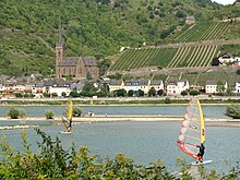
Lorchhausen , also Lorchhausen in the Rheingau , is a district of the city of Lorch and a border town between Hesse and Rhineland-Palatinate . The formerly independent municipality of Lorchhausen has its own local district with a local advisory board . The village is the westernmost and, at 75 meters above sea level on the banks of the Rhine, the lowest in all of Hesse.
geography
location
Lorchhausen is located on the right bank of the Rhine at river kilometer 542 at the mouth of the 3.2 kilometer long Retzbach and is considered the gateway to the Rheingau . The houses of the village crowd at the foot of the steep rocky slopes of the Rhenish Slate Mountains along the banks of the Rhine and in the lower Retzbach valley , which extends to the vicinity of the highest elevation of the Lorchhausen district, the 422 meter high silver mine . In addition to the Retzbachtal , the district also has a share in the Niedertal , which was the border between the Rheingau and the Electoral Palatinate for centuries . After the Second World War, this was the zone boundary between the American zone of occupation , to which Lorchhausen belonged, and the French zone of occupation . At the same time, the Niedertal became the state border between Hesse and Rhineland-Palatinate . In the east, the Lorchhausen Forest falls down to the boundary in the Tiefenbachtal and includes the Waldeck ruins , which are located next to the Sauerburg .
Neighboring communities
The district boundary of Lorchhausen lies in the west in the navigation channel of the Rhine, there at the same time as the state border to Rhineland-Palatinate. Bacharach and Oberdiebach are on the opposite bank . Neighboring towns in the north are Kaub and Sauerthal . In the east and south, the district of the core city of Lorch connects. The buildings in Lorchhausen and Lorch gradually grew together along the banks of the Rhine after the Second World War.
history
Lorchhausen was first mentioned in a document in 1211 in an inventory of the Eberbach monastery and, as a settlement of Lorcher noble miners, formed a community with Lorch until 1773. With the Reichsdeputationshauptschluss Lorchhausen came in 1803 to the Principality of Nassau-Usingen , which in 1806 by Napoleon I to the Duchy of Nassau was charged. In 1866 Lorchhausen, like all of Nassau, was incorporated into the Kingdom of Prussia and was part of the Hesse-Nassau province .
After the First World War, the place was in a small area, the Free State of Bottleneck, between the zones of occupation of the Americans and French. The area existed from 1919 to 1923.
Since 1946 the place has been part of the state of Hesse, which was founded by the Americans . On October 1, 1971, as part of the regional reform in Hesse, the new merger with Lorch took place.
coat of arms
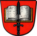
The municipality of Lorchhausen in the Rheingaukreis was granted a coat of arms with the following blazon on May 6, 1958 by the Hessian Minister of the Interior :
In red an open silver Bible, pierced by a black sword.
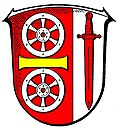
In 1973 it was replaced by a jointly designed coat of arms of the town of Lorchhausen and the town of Lorch in the course of the voluntary merger and approved on February 28, 1973 by the Hessian Minister of the Interior with the following blazon :
Shield split in a ratio of 2: 1: Two silver wheels on top of each other in red at the front, separated by a horizontal golden bar; behind in silver a red sword on a white background.
In the new coat of arms the sword stands for the pierced St. Boniface Bible, but also for the sword of the coat-dividing St. Martin from the old Lorch coat of arms. The Mainz wheel symbolizes the fact that it has belonged to the Electorate of Mainz for centuries; the colors red and white represent the state of Hesse.
Attractions
- former parish church St. Bonifatius (Lorchhausen) today a branch church of the parish Heilig Kreuz Rheingau
- Clement Chapel
- Rectory
see also the list of cultural monuments in Lorch (Rhg) - Lorchhausen district
Economy and Infrastructure
Viticulture
Lorchhausen is a traditional wine-growing place in the Rheingau growing area with around 20 hectares of vineyards, which is mainly planted with Riesling vines , but also with Pinot Noir. This is where the Rheingau Riesling route begins , which leads east to Wicker through all Rheingau wine-growing communities.
traffic
The traffic connection from Lorchhausen is on the road side exclusively through the federal highway 42 , which runs directly on the bank of the Rhine.
On May 1, 1906 (the beginning of the summer timetable for that year), the Lorchhausen stop on the right Rhine route went into operation. When the Rhine was flooded, as in 1988 and 1993, when the main road was flooded, the railway was the only connection that could be used.
Web links
- Lorchhausen district. In: Internet presence. City of Lorch
- Lorchhausen. Local history, information. In: www.lorchhausen.de. Private website
- Lorchhausen, Rheingau-Taunus-Kreis. Historical local dictionary for Hessen. In: Landesgeschichtliches Informationssystem Hessen (LAGIS).
- Literature about Lorchhausen in the Hessian Bibliography
Individual evidence
- ↑ Main statutes of the city of Lorch am Rhein 2011 (PDF file 190 kB)
- ↑ a b Topographic map 1: 25,000
- ^ Federal Statistical Office (ed.): Historical municipality directory for the Federal Republic of Germany. Name, border and key number changes in municipalities, counties and administrative districts from May 27, 1970 to December 31, 1982 . W. Kohlhammer GmbH, Stuttgart and Mainz 1983, ISBN 3-17-003263-1 , p. 375 .
- ↑ Approval of a coat of arms of the municipality of Lorchhausen in the Rheingaukreis, administrative district Wiesbaden from May 6, 1958 . In: The Hessian Minister of the Interior (ed.): State Gazette for the State of Hesse. 1958 No. 20 , p. 557 , point 482 ( online at the information system of the Hessian state parliament [PDF; 3,4 MB ]).
- ↑ Approval of a coat of arms of the city of Lorch, Rheingaukreis from February 28, 1973 . In: The Hessian Minister of the Interior (ed.): State Gazette for the State of Hesse. 1973 No. 12 , p. 541 , point 401 ( online at the information system of the Hessian state parliament [PDF; 4.1 MB ]).
- ^ Rheingauer Weinbauverband: Rheingauer Riesling Route ( Memento from April 29, 2012 in the Internet Archive )
- ^ Eisenbahndirektion Mainz (Ed.): Official Journal of the Royal Prussian and Grand Ducal Hessian Railway Directorate in Mainz from April 28th. 1906, No. 24. Nachrichten, pp. 229f.


