
Battenberg Castle
| Battenberg Castle | ||
|---|---|---|
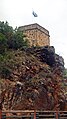
 Battenberg castle ruins seen from the south (2007) |
||
| Creation time : | 13th Century | |
| Castle type : | Höhenburg , spur location | |
| Conservation status: | ruin | |
| Standing position : | Count | |
| Place: | Battenberg (Palatinate) | |
| Geographical location | 49 ° 31 '56 " N , 8 ° 8' 41" E | |
| Height: | 280 m above sea level NHN | |
|
||

The Battenberg Castle is a ruinous castle in the district of Bad Dürkheim ( Rheinland-Pfalz ).
geography
location
The ruin of the hilltop castle is located near the end of the Leininger spur on the northeastern edge of the Palatinate Forest in the area of the western shoulder of the Upper Rhine Graben at 280 m above sea level. NHN . North and south of the castle hill, the valleys of the open Eckbachs and its right inflow Krumbach to Rhine valley . The local community of the same name is grouped immediately to the west of the castle .
Surroundings
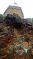
On the steep southern slope immediately below the castle ruins, the so-called lightning tubes emerge from the ocher- colored sandstone next to the winding county road 30 . However, the natural monument was not created by lightning , but by sintering and erosion of highly ferrous minerals .
The Haardtrand nature reserve - Im Baumgarten is located on the eastern slope of the castle hill.
investment


The ground plan of the castle follows the steep mountain spur on three sides (north, east, south) . Against the open fourth side, which is to the west, it was protected by a ditch that is now completely flattened .
The circular wall with the gate on the west side or the north-west corner of the facility and a battery tower in the middle of the south side, which has a mouth hole , have been preserved. In addition, in the eastern area there is the ground floor of a residential building above a vaulted cellar, with a two-story stair tower attached to the west , which was later converted into an east-facing pavilion in the upper area. Its upper floor can be reached from the terrace in front of it through a retrofitted iron external staircase. This terrace, with a wide view of the Rhine plain , used to form the floor of the 2nd floor of the residential building. From there to the battery tower there is a battlement behind the curtain wall.
To the north of the gate there are two coach houses from the 18th century which, together with a nicely laid out part of the castle courtyard, currently serve as a restaurant.
history
Probably the castle was built in the 13th century by Count Friedrich III. von Leiningen († 1287) built on the remains of a Salic complex. She stood in the possession of Leininger Counts , which at that time the Leiningerland belonged. Together with Neuleiningen Castle , 1400 m to the north , it controlled the entrance to the Eckbach Valley. Altleiningen, an ancestral castle in Lining, is located 5 km south-west upstream . During the Palatinate War of Succession , the facility was destroyed by French troops in 1689 . Partially renovated, it remained one of the Leininger residences until 1747.
According to local tradition, which is also recorded on the information board in the courtyard, Marshal Tallard and General Melac ate an opulent dinner here on May 22, 1693 and watched from a distance the burning Heidelberg that they had set alight.
On the night of September 5, 1794, the future Prince Blücher and his troops drove out the French revolutionary army , which had occupied the strategically important place during the 1st coalition war. On the 18th of the month there were renewed battles around the castle complex , with the later generals Friedrich Wilhelm von Müffling and Joseph von Cloßmann leading the assault on the Battenberg. Both times, Palatinate-Bavarian troops played a decisive role in the fighting.
Today the ruins are privately owned, but most of them are open to the public. The exposed location allows a wide view to the east of the Rhine plain, Bergstrasse and Odenwald .
gallery

Battenberg Castle from the east

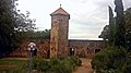
Castle gate from the outside, behind it restaurant building

Castle gate from the outside

Castle gate from the inside, restaurant building on the right

Today's restaurant building from the 18th century
Stair tower from the courtyard

Stair tower from the terrace
Stair tower with the rest of the main building, from the courtyard

Stair tower, rest of the main building and battlements to the battery tower

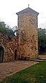
Battlements with battery tower

Battery tower south side
Battery tower
Battery tower

Battery tower
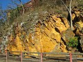
The lightning tubes below the castle ruins


literature
- Jürgen Keddigkeit , Alexander Thon, Karl Scheurer, Rolf Übel : Palatinate Castle Lexicon . 2nd Edition. tape 1 : A-E . Institute for Palatinate History and Folklore, Kaiserslautern 2003, ISBN 3-927754-51-X , p. 212-218 .
Web links
Individual evidence
- ^ Landscape information system of the Rhineland-Palatinate nature conservation administration. Nature Conservation Administration Rhineland-Palatinate, accessed on October 15, 2013 .
- ↑ Local community Battenberg - natural monument "Blitzröhren". (No longer available online.) Bad Dürkheim district , archived from the original on October 16, 2013 ; Retrieved October 14, 2013 . Info: The archive link was inserted automatically and has not yet been checked. Please check the original and archive link according to the instructions and then remove this notice.
- ^ Illustrated website of the Burgschänke
- ↑ Jürgen Keddigkeit, Alexander Thon, Karl Scheurer, Rolf Übel: Palatinate Burgenlexikon . tape 1 : A – E , 2003, pp. 212-218 .
- ↑ The Bavarian Soldier in the Field , Kriegsarchiv Munich, 1898, Volume 1, p. 39 u. 40
- ^ Oscar von Sichlern: History of the Royal Bavarian 5th Chevaulegers Regiment "Prinz Otto" , Munich, 1876, p. 42; (Digital scan)