
Laumersheim
| coat of arms | Germany map | |
|---|---|---|

|
Coordinates: 49 ° 33 ' N , 8 ° 14' E |
|
| Basic data | ||
| State : | Rhineland-Palatinate | |
| County : | Bad Dürkheim | |
| Association municipality : | Leiningerland | |
| Height : | 110 m above sea level NHN | |
| Area : | 4.86 km 2 | |
| Residents: | 907 (Dec. 31, 2019) | |
| Population density : | 187 inhabitants per km 2 | |
| Postal code : | 67229 | |
| Area code : | 06238 | |
| License plate : | DÜW | |
| Community key : | 07 3 32 033 | |
| LOCODE : | DE LHM | |
| Association administration address: | Industriestrasse 11 67269 Grünstadt |
|
| Website : | ||
| Local Mayor : | Arno Wieber ( CDU ) | |
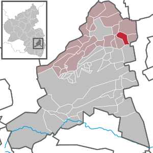
| Location of the local community Laumersheim in the Bad Dürkheim district | ||
  |
||

Laumersheim is a municipality in the Rhineland-Palatinate district of Bad Dürkheim and is located in the northwest of the European metropolitan region of Rhine-Neckar . The wine-growing village belongs to the community of Leiningerland .
geography

Laumersheim is located in the historic Leiningerland in the floodplain of the Eckbach , which flows through the village from southwest to northeast. The landscape is characterized by the hilly transition area between the low mountain range and the plains; to the west the Haardt rises as the eastern edge of the Palatinate Forest , to the east the Upper Rhine Plain extends .
The hill structure is particularly pronounced to the left of the Eckbach, northwest of Laumersheim. There lies the Goldberg , a 162 m high elevation over which the watershed runs between the catchment areas of the Eckbach in the south and its left tributary Floßbach in the north. To the right of the Eckbach and south of the village, the 137 m high Palmberg is a much less prominent hill.
Neighboring communities, clockwise, are Obersülzen in the north-west, Dirmstein in the north-east, Gerolsheim in the south-east, Weisenheim am Sand in the south and Großkarlbach in the south-west. With the exception of Weisenheim (4 km, Freinsheim community ), they are each around 2 km away and, like Laumersheim, belong to the Leiningerland community.
history
The place was first mentioned as Liutmarsheim towards the end of the 8th century; this speaks for a Franconian founder named Liutmar or Ludmar . Around 1155 the village came to the then Hohenstaufen Count Palatine , who gave it as a fief to the Leininger . The lords of Lumersheim have been attested since 1255 . Later, the Lords of Randeck , the Löwensteiner , the Flersheimer , the Electoral Palatinate and - from 1705 - the Duchy of Worms held the property.
In 1364 Laumersheim received by Emperor Charles IV. , The town charter , but lost them already in 1422 again. After the elevation to the city, the place was also fortified. However, the walls are no longer visible today, they were badly damaged in the Peasants' War in 1525 and completely destroyed by the French in the War of the Palatinate Succession in 1689 . The baroque Laumersheim Palace in the center of the village goes back to a moated castle that Hans von Flersheim , father-in-law of the knight Franz von Sickingen , had built in 1492.
The place belonged to the district of Frankenthal (Pfalz) until it was dissolved in 1969. After the move to the new Bad Dürkheim district in the same year, Laumersheim was assigned to the also newly formed community of Grünstadt-Land in 1972 , which was merged into the community of Leiningerland in 2018.
After more than two years of lead time, on September 15, 2012, the missing person researcher Uwe Benkel and his helpers unearthed wreckage and human remains from the crash of a British Lancaster bomber in World War II in a field on the outskirts . This was shot down from an operation on the night of April 16-17, 1943 while flying back. At that time body parts of two of the seven inmates could be recovered; the remnants of the other five had sunk with the wreck about 4 to 5 m deep in the marshy terrain south of the Eckbach, which was later drained for agricultural use.
religion
In 2012, 45.3% of the population were Protestant and 28.9% Catholic. The rest belonged to another religion or were non-denominational.
In Laumersheim there is one of the catholic and thus denominational cemeteries in the diocese of Speyer .
politics
Municipal council
The council in Laumersheim consists of twelve council members, who in the local elections on May 26, 2019 in a majority vote were elected, and the honorary mayor as chairman.
The distribution of seats in the municipal council:
| choice | SPD | CDU | FWG | total |
|---|---|---|---|---|
| 2019 | 4th | 3 | 5 | 12 seats |
| 2014 | 5 | 3 | 4th | 12 seats |
| 2009 | 5 | 3 | 4th | 12 seats |
| 2004 | 5 | 3 | 4th | 12 seats |
- FWG = Free Voting Group Laumersheim e. V.
mayor
The local mayor is Arno Wieber (CDU). In the direct election on May 26, 2019, he prevailed against the previous mayor Thomas Diehl (SPD), who has been in office since 2004, with a share of 53.64% of the vote.
coat of arms
|
|
Blazon : "Divided, top in black, besätem with golden crosses field with downward gekehrtem beard diagonally right-lying silver key, below in blue right one sechsstrahliger gold star, left an increasing golden crescent." |
| Justification for the coat of arms: It was approved by the Bavarian State Ministry of the Interior in 1924 and goes back to a seal from 1538. This had also contained the Palatinate Lion , which was removed from the representation after the transition from the Electoral Palatinate to the Diocese of Worms (1705). |
Attractions

Holy Cross Chapel

Altar of the Holy Cross Chapel
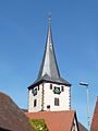
Tower of the St. Bartholomew Church

Window of the St. Bartholomew Church

Former Laumersheim Castle

Gate entrance of the former castle


Pilgrimage chapel
To the south of Laumersheim on the Palmberg ( 137 m , only slightly higher than the town, but still with a wide panoramic view) there is an octagonal pilgrimage chapel built in 1722 . In the windowless interior there is a crucifixion group from the 18th century as well as copies of medieval figures, the originals of which are kept in the Historical Museum of the Palatinate in Speyer .
Bartholomäuskirche
The Catholic Church of St. Bartholomew was once a branch of the later abandoned village of Berghaselbach on Palmberg.
The tower with choir still dates from the Gothic period of construction . Wall paintings from the beginning of the 14th century have been preserved in the sacristy . Three valuable wooden figures from 1520 also survived to this day. After the village and the church were set on fire by French troops in the Palatinate War of Succession in 1689, the nave was rebuilt in 1719 at the instigation of the local nobleman Franz Caspar von Langen .
lock
Only the southern part of the former Laumersheim Castle , which was the Baroque successor to a water castle from the 15th century, is preserved. It is in a poor structural condition.
Mills
The willow and horning mills were once operated on the Eckbach . The Eckbach-Mühlenwanderweg leads with a slight gradient along the stream through the village.
Economy and Infrastructure
economy

For many residents who commute to their workplaces 25–30 km away in the Ludwigshafen / Mannheim area , Laumersheim is primarily a residential community ; There is no industry here.
Agriculture is strongly influenced by viticulture . Above all, fine red wines from the place (e.g. Pinot Noir and St. Laurent ), which are often aged in barrique barrels , are sold throughout Germany. The Kapellenberg , whose 32.8 hectares are mostly on the Palmberg, is a valued location . The local wine cooperative is named after this hill . There and in the other locations of Kirschgarten (43.8 hectares) and Mandelberg (51 hectares, Steinbuckel again from the 2009 vintage ), full-bodied wines with pronounced fruit aromas thrive on calcareous loess loam soils.
With around 50 hectares of fruit growing area, 80% of which are table apples, Laumersheim now accounts for a significant share of the regional fruit production.
traffic
Laumersheim lies between Frankenthal and Grünstadt next to the A 6 (Mannheim– Saarbrücken ), but does not have its own motorway connection. The distance to junction 19 Grünstadt is 5 km. The state roads 455 (Dirmstein – Freinsheim) and 454 (Obersülzen – Weisenheim) run through the village and cross in the center of the village.
For almost half a century, from 1891 to 1939, the place benefited from the local railway , a single-track, narrow - gauge line with a gauge of 1000 mm. It led from Frankenthaler Bahnhof, where the connection to the Reichsbahn was made, westwards to Großkarlbach.
Personalities
Sons and daughters of the church
- Joseph von Camuzi (1767–1828), landowner, Bavarian Privy Council , mayor in neighboring Dirmstein, member of the Chamber of Deputies of the Kingdom of Bavaria
- Gideon von Camuzi (1799–1879), son of Joseph von Camuzi, landowner and mayor in neighboring Dirmstein, member of the Chamber of Deputies of the Kingdom of Bavaria
- Michael Krück (1842–1919), Bavarian educator
- Moritz Mayer (1864–1942), Counselor in Frankenthal, victim of the Holocaust
- Johann Christian Eberle (1869–1937), "father" of savings and giro transactions
People who worked on site
- Felix Hell (* 1985), organ virtuoso, grew up in Laumersheim.
- Franz Caspar von Langen (1651 / 52–1737), owner of the Laumersheim Castle , promoted the reconstruction of the St. Bartholomew Church.
literature
- Literature about Laumersheim in the Rhineland-Palatinate State Bibliography
Web links
- Local community Laumersheim on the website of the Verbandsgemeinde Leiningerland
- SWR , Hierzuland Rhineland-Palatinate: Laumersheim , town portrait, March 29, 2004
Individual evidence
- ↑ State Statistical Office of Rhineland-Palatinate - population status 2019, districts, communities, association communities ( help on this ).
- ^ Antje Landmann: Airplane wheels on the wheelbarrow . In: Die Rheinpfalz , local edition Frankenthaler Zeitung . Ludwigshafen April 26, 2010.
- ↑ Remains of British bomber crew recovered. Südwestrundfunk , September 16, 2012, accessed on September 28, 2012 .
- ↑ Frank Geller: History to touch . In: Die Rheinpfalz , local edition Frankenthaler Zeitung . Ludwigshafen September 17th, 2012.
- ↑ KommWis, as of August 31, 2012.
- ^ The Regional Returning Officer RLP: City Council Election 2019 Laumersheim. Retrieved October 14, 2019 .
- ^ The Regional Returning Officer Rhineland-Palatinate: Municipal elections 2014, city and municipal council elections.
- ^ The regional returning officer RLP: direct elections 2019. see Leiningerland, Verbandsgemeinde, 15th line of results. Retrieved October 14, 2019 .
- ^ Karl Heinz Debus: The great book of arms of the Palatinate . Neustadt an der Weinstrasse 1988, ISBN 3-9801574-2-3 .

Altleiningen | Bad Dürkheim | Battenberg (Palatinate) | Bissersheim | Bobenheim am Berg | Bockenheim an der Weinstrasse | Carlsberg | Dackenheim | Deidesheim | Dirmstein | Ebertsheim | Ellerstadt | Elmstein | Erpolzheim | Esthal | Forest on the Wine Route | Frankeneck | Freinsheim | Friedelsheim | Gerolsheim | Gönnheim | Grosskarlbach | Grünstadt | Hassloch | Herxheim am Berg | Hettenleidelheim | Kallstadt | Children's home | Kirchheim an der Weinstrasse | Kleinkarlbach | Lambrecht (Palatinate) | Laumersheim | Lindenberg | Meckenheim | Mertesheim | Neidenfels | Neuleiningen | Niederkirchen near Deidesheim | Obersülzen | Obrigheim (Palatinate) | Quirnheim | Ruppertsberg | Tiefenthal | Wachenheim an der Weinstrasse | Wattenheim | Weidenthal | Weisenheim am Berg | Weisenheim am Sand