
Dackenheim
| coat of arms | Germany map | |
|---|---|---|

|
Coordinates: 49 ° 31 ' N , 8 ° 11' E |
|
| Basic data | ||
| State : | Rhineland-Palatinate | |
| County : | Bad Dürkheim | |
| Association municipality : | Freinsheim | |
| Height : | 170 m above sea level NHN | |
| Area : | 3.32 km 2 | |
| Residents: | 431 (Dec. 31, 2019) | |
| Population density : | 130 inhabitants per km 2 | |
| Postal code : | 67273 | |
| Area code : | 06353 | |
| License plate : | DÜW | |
| Community key : | 07 3 32 008 | |
| LOCODE : | DE DPZ | |
| Association administration address: | Bahnhofstrasse 12 67251 Freinsheim |
|
| Website : | ||
| Local Mayor : | Edwin closet | |
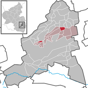
| Location of the local community Dackenheim in the Bad Dürkheim district | ||
  |
||

Dackenheim is a municipality in the Bad Dürkheim district in Rhineland-Palatinate . It belongs to the Freinsheim Association .
geography
location
The community is located in the Palatinate in the north of the German Wine Route . Dackenheim is located in the foothills between the Palatinate Forest and the Rhine plain . The Palatinate Forest Nature Park begins to the west of the village .
climate
The annual precipitation is 534 mm. The rainfall is very low. They are in the lower tenth of the values recorded in Germany. Lower values are registered at eight percent of the German Weather Service's measuring stations . The driest month is January, with the most rainfall in May. In May there is 1.9 times more rainfall than in January. The rainfall is distributed fairly evenly over the year. Lower seasonal fluctuations are recorded at 32% of the measuring stations .
history
When the Dackenheim golf course was laid out in 1998, prehistoric evidence in the form of vessel fragments was discovered that was assigned to the Rössen culture (4700-4500 BC), which leads to the assumption that Dackenheim - like the neighboring town of Freinsheim - was already in the Neolithic could have been populated. A find from the year 1952 is likely from the late Celtic period, a grave site with a head relief, which is in the Palatinate History Museum .
Franks and Carolingians
Evidence from Roman times cannot be proven. The suffix “-heim” in the place name suggests that Dackenheim was founded around 600, ie at the time of the Franconian conquest of the land . Grave finds from 1910 in the corridor "In den 24 Morgen" and 1976 in the corridor "Am Liebesbrunnen" provided clear indications of settlement during the Merovingian era .
12th to 18th centuries
In the 12th century Dackenheim belonged to the sphere of influence of the Counts of Leiningen . The construction of the Catholic Church (1147) dates from this time.
As a result of the Mainz archbishopric and the Baden-Palatinate War and after the death of Margarethe von Leiningen-Westerburg, Dackenheim fell to the Electoral Palatinate in 1471 . The main source of the following time is the "Dackenheimer Weistum " from 1485 as well as 1496 and 1579. Dackenheim remained in the possession of the Palatinate until the end of the 18th century. During this time, the construction of a new Lutheran church began in 1716 (rebuilt in 1857).
French and Bavarian time
During the First Coalition War , French revolutionary troops occupied the left bank of the Rhine in 1794 . From 1798 to 1814 Dackenheim belonged to the French canton of Dürkheim in the Département du Mont-Tonnerre (Donnersberg), around 1800 Dackenheim became the chief town ( chef-lieu ) of a Mairie .
Due to the agreements made at the Congress of Vienna and an exchange contract with Austria , the Palatinate came to the Kingdom of Bavaria in 1816 . Under the Bavarian administration, the community of Dackenheim belonged to the Landkommissariat Neustadt .
politics
Municipal council
The municipal council in Dackenheim consists of eight council members, who were elected by a majority vote in the local elections on May 26, 2019 , and the honorary local mayor as chairman.
mayor
Local mayor is Edwin cabinet. In the direct election on May 26, 2019, he was confirmed in his office with 55.56% of the votes.
coat of arms
|
|
Blazon : “In red on a green background next to each other, each in golden clothes with a golden crown and silver halo, on the right the Mother of God with the child on her right arm, on the left St. Catherine, in the right a lowered silver sword with a golden pommel and a broken one red wheel at her feet, above between the crowns and glorioles a six-pointed golden star. " |
Sights and culture


Architectural monuments
The center of the village, which grew together from five monastery courtyards in the 12th century, is its Catholic parish church of St. Maria. It belonged to the Höningen monastery since 1147 . The Romanesque tower with round arch frieze in the basement and double arcades on the upper floor as well as the choir apse with 3/8 end date from this period. The nave was in the 18./19. Century renewed. A relief of the Fall of Man from the previous building - possibly from the portal tympanum - was integrated in the gable .
In the single-nave interior, the choir pillars with rich capital decorations (palmettes, heads, seated figures) are also still Romanesque.
Next to the church is a small vintner's fountain with a Bacchus figure.
With the introduction of the Reformation in 1567, the formerly Catholic Church was added to the Dackenheim Protestants. When the Electoral Palatinate, with Elector Johann Wilhelm , was ruled by a Catholic prince again from 1698, both denominations had to share what was previously the only church. Probably in 1684, but no later than 1705, the construction of the Protestant church began. Completed in 1717, the Protestant church was converted into an upstairs church in 1857 and received its current form, a hall structure with a gallery and a roof turret with an octagonal bell chamber and an onion-shaped dome. On the south wall are the altar table and pulpit, which can be reached from the parish chair , which is surrounded by a wooden lattice, via a staircase. The organ was built in 1875 by EF Walcker & Cie. built.
See also: List of cultural monuments in Dackenheim
golf

The golf course, which was built on the western outskirts of Dackenheim in 1995 and expanded to a 27-hole course in 2005, gave Dackenheim another recreational impetus beyond its traditional self-image as a wine village.
The course is part of the so-called rotation golf concept of Mannheim golf course architect and investor Hermann Weiland with seven other golf courses in the Rhine-Main area , the Palatinate and Saarland .
In cooperation with the Mainz State Institute for Plant Cultivation and Plant Protection, over 2000 vines and fruit trees were planted on the site. This “educational trail” - it is called the golf garden - is designed in such a way that the first 18 holes are named after the surrounding grape varieties and the holes 19-27 after the corresponding fruit varieties. According to our own advertising materials, players and hikers outside the area are free to try the fruit.
Economy and Infrastructure
Viticulture
On the situation Dackenheimer Liebesbrunnen mainly are Riesling , Gewurztraminer , Sylvaner and Pinot Noir hammered, also Scheurebe , Kerner , Pinot Blanc and Pinot Gris , as well as rare vines such as Lemberger or St. Laurent . There are also small test areas for new breeds. It is mostly dry, but partly also semi-dry and mild. Some of them mature traditionally in barrique and oak barrels. Several family wineries and wine cooperatives offer free on-site sales with wine tastings. Individual wines have received awards in different years.
Mandelröth with a focus on Chardonnay and Kapellengarten are smaller Dackenheimer locations.
traffic
A single main road leads from the federal road 271 (the "actual" German Wine Road) through the center of the town past the church three kilometers east to Freinsheim . Small alleys with houses, courtyards and wineries stretch away from the thoroughfare.
Picture gallery

Catholic Church

protestant church
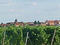
Townscape

Golf club

Dackenheim love fountain


literature
- Ludwig Emrich / Wolfgang Best: Dackenheim - building blocks of a chronicle. Freinsheim 2004, 215 p. (Small edition, available from the mayor of Dackenheim)
- Literature about Dackenheim in the Rhineland-Palatinate state bibliography
Web links
Individual evidence
- ↑ State Statistical Office of Rhineland-Palatinate - population status 2019, districts, communities, association communities ( help on this ).
- ^ The Regional Returning Officer RLP: City Council Election 2019 Dackenheim. Retrieved October 15, 2019 .
- ^ The Regional Returning Officer RLP: direct elections 2019. see Freinsheim, Verbandsgemeinde, second. Result line. Retrieved October 15, 2019 .

Altleiningen | Bad Dürkheim | Battenberg (Palatinate) | Bissersheim | Bobenheim am Berg | Bockenheim an der Weinstrasse | Carlsberg | Dackenheim | Deidesheim | Dirmstein | Ebertsheim | Ellerstadt | Elmstein | Erpolzheim | Esthal | Forest on the Wine Route | Frankeneck | Freinsheim | Friedelsheim | Gerolsheim | Gönnheim | Grosskarlbach | Grünstadt | Hassloch | Herxheim am Berg | Hettenleidelheim | Kallstadt | Children's home | Kirchheim an der Weinstrasse | Kleinkarlbach | Lambrecht (Palatinate) | Laumersheim | Lindenberg | Meckenheim | Mertesheim | Neidenfels | Neuleiningen | Niederkirchen near Deidesheim | Obersülzen | Obrigheim (Palatinate) | Quirnheim | Ruppertsberg | Tiefenthal | Wachenheim an der Weinstrasse | Wattenheim | Weidenthal | Weisenheim am Berg | Weisenheim am Sand