Meckenheim (Palatinate)
| coat of arms | Germany map | |
|---|---|---|

|
Coordinates: 49 ° 24 ' N , 8 ° 14' E |
|
| Basic data | ||
| State : | Rhineland-Palatinate | |
| County : | Bad Dürkheim | |
| Association municipality : | Deidesheim | |
| Height : | 111 m above sea level NHN | |
| Area : | 15.06 km 2 | |
| Residents: | 3393 (Dec. 31, 2019) | |
| Population density : | 225 inhabitants per km 2 | |
| Postal code : | 67149 | |
| Area code : | 06326 | |
| License plate : | DÜW | |
| Community key : | 07 3 32 035 | |
| Association administration address: | At the train station 5 67146 Deidesheim |
|
| Website : | ||
| Mayoress : | Julia Kren (FWG) | |
| Location of the local community of Meckenheim in the Bad Dürkheim district | ||
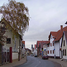
Meckenheim is a municipality in the Bad Dürkheim district in Rhineland-Palatinate . It belongs to the Deidesheim community , within which it is the second largest local community in terms of population.
Geographical location
The community lies on the edge of the Weinstrasse region in the Upper Rhine Plain and is part of the Rhine-Neckar metropolitan region . The Marlach grazes the northern edge of the settlement. The Sandhof also belongs to Meckenheim . Neighboring communities are - clockwise - Rödersheim-Gronau , Hochdorf-Assenheim , Böhl-Iggelheim , Haßloch , Neustadt an der Weinstrasse , Ruppertsberg , Deidesheim and Niederkirchen near Deidesheim .
history
The Franconian village of Meckenheim was probably built in the 5th century. In the year 768, a first donation from Meckenheim to the Lorsch Monastery was documented, further donations followed. In 991 some Meckenheim goods fell to Otto I , Duke of Carinthia, known as "Otto von Worms". The Agidius Church was built in the 12th century.
In 1287 Meckenheim was bought by Count Palatine Ludwig II ; from then on it belonged to the Electoral Palatinate . In 1459/60 Meckenheim was burned down by the Leiningers (Emich VII.). With the introduction of the Reformation in the Electoral Palatinate, Meckenheim became Protestant. In 1585 the Agidius Church was rebuilt.
After massive devastation in the Thirty Years War , Meckenheim was deserted by its inhabitants in 1641. The Meckenheim church fell to the Catholics in 1707; The Protestant church was built in 1747/48. During the First Coalition War at the end of the 18th century, Meckenheim suffered great damage. From 1798 to 1814, when the Palatinate was part of the French Republic (until 1804) and then part of the Napoleonic Empire , Meckenheim was incorporated into the canton of Neustadt (Donnersberg) and formed its own Mairie . In 1815 the place had 1,484 inhabitants. In the same year it was slammed into Austria as a result of the resolutions of the Congress of Vienna . Just one year later, the place, like the entire Palatinate, changed to the Kingdom of Bavaria . From 1818 to 1862 the community belonged to the Landkommissariat Neustadt ; from this the district office of Neustadt emerged.
The school and community center (Hauptstrasse 98) was built in 1824, and today's town hall (Hauptstrasse 58) in 1872. In 1894 the agricultural reference and sales cooperative and the Raiffeisenkasse were founded, which were merged in 1938.
In 1913 Meckenheim was connected to a general power line and in 1928 to a general water line. The Meckenheim winegrowers' association was founded in 1922, and the fruit market hall was built in 1936. From 1939 Meckenheim was part of the district of Neustadt an der Weinstrasse . After the Second World War , the place became part of the then newly formed state of Rhineland-Palatinate within the French occupation zone . In 1952/55 the sports field with the sports center was laid out. In 1956 Meckenheim was connected to a general gas pipeline, in 1961 a new elementary school and in 1964 a connection to a sewer system. In the course of the first Rhineland-Palatinate administrative reform , the place moved in 1969 to the newly created district of Bad Dürkheim . Three years later, Meckenheim became part of the also newly formed Deidesheim association .
religion
At the end of 2017, 37.7 percent of the population were Protestant and 30.1 percent were non-denominational. 28.6 percent were Catholic and 3.6 percent belonged to another religion.
politics
Municipal council
The municipal council in Meckenheim consists of 20 council members, who were elected in a personalized proportional representation in the local elections on May 26, 2019 , and the honorary local mayor as chairman.
The distribution of seats in the municipal council:
| choice | SPD | CDU | FWG | total |
|---|---|---|---|---|
| 2019 | 4th | 7th | 9 | 20 seats |
| 2014 | 4th | 5 | 11 | 20 seats |
| 2009 | 5 | 4th | 11 | 20 seats |
| 2004 | 6th | 4th | 10 | 20 seats |
- FWG = Free Voting Group Meckenheim e. V.
mayor
The local mayor of Meckenheim is Julia Kren (FWG). In the local election on May 26, 2019, she was elected with 53.29 percent of the vote. Her predecessor was Heiner Dopp .
coat of arms
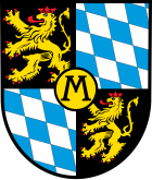
| Blazon : “In a square shield top right and bottom left in black a red armored, tongued and crowned golden lion ( Palatinate lion ), roughened top left and bottom right of silver and blue, in the middle covered with a black-rimmed golden circle a black M. " | |
| Justification of the coat of arms: It was approved by the Bavarian State Ministry of the Interior in 1926 and goes back to a court seal from 1473. It corresponds to the coat of arms of the Electoral Palatinate, which is covered with the district mark. |
partnership
The municipality has been linked to Lugny in France in partnership since 1980 .
The community has been on friendly terms with Grabenstätt am Chiemsee since 1967 .
Culture
There are 17 objects on site that are listed buildings. There are also five natural monuments in Meckenheim .
Infrastructure
Viticulture
The Meckenheim vineyards belong to the Palatinate wine-growing region and here in turn to the Mittelhaardt-Deutsche Weinstrasse cultivation area . Meckenheim has three individual layers, namely Linsenbusch , Neuberg and Spielberg , all of which are part of the Hofstück site .
In Meckenheim there are 35 wine-growing businesses which cultivate 0.5 hectares (ha) or more of planted vineyards ; the average vineyard area per farm is 8 hectares. The total vineyard area on Meckenheimer area is 271 hectares. 57.9% of the wines produced by Meckenheimer wine-growing operations are white wines and 42.1% are red wines (status: 2010).
traffic
Meckenheim was once the southern end of a military road that led to Mühlheim an der Eis . In 1911 the local line Ludwigshafen – Dannstadt, opened in 1890, was continued to Meckenheim; operation was maintained until 1955, when it was replaced by bus routes.
The state road 519 , which leads to Mußbach, formerly formed the federal road 38 and was downgraded to a state road in connection with the opening of the nearby federal highway 65 , which touches the southeast of the municipality marker. The state road 530 connects the place among other things with Haßloch and Mutterstadt. The county road 10 connects it to Ruppertsberg . Federal road 271 runs through the west of the district for a few hundred meters .
The Salier cycle path also runs through Meckenheim .
Personalities
Sons and daughters of the church
- Johann Jakob Rieger (1754–1811), painter, draftsman and graphic artist
- Georg Friedrich Dürk (1788–1877), Napoleonic soldier, knight of the French Legion of Honor
- Eduard Faber (1853–1930), hydraulic engineer
- Ludwig Scharf (1864–1939), poet and translator
- Jakob Müller (1883–1969), politician (FDP)
- Paul Ohler (1887–1968), detective
- Norbert Meder (* 1947), educator
People who worked on site
- John Kriebitzsch (1857-1938), glass painter, in 1905 paid the windows of the Catholic Church of St. Giles from
- Armin Otto Huber (1904–1977), writer, died on site
- Fritz Seitz (1905–1949), priest, was at times a chaplain on site
- Heiner Dopp (* 1956), hockey player, local mayor from 1999 to 2019
- Steffen Drays, 2008 winner of the "throwing up" discipline of the world championship in throwing Christmas trees , lives on site
literature
- Literature about Meckenheim in the Rhineland-Palatinate State Bibliography
Web links
Individual evidence
- ↑ State Statistical Office of Rhineland-Palatinate - population status 2019, districts, communities, association communities ( help on this ).
- ^ Karl Josef Minst [transl.]: Lorscher Codex (Volume 4), Certificate 2072, April 13, 768 - Reg. 272. In: Heidelberg historical stocks - digital. Heidelberg University Library, p. 31 , accessed on May 25, 2018 .
- ↑ List of places for the Lorsch Codex, Meckenheim , Archivum Laureshamense - digital, Heidelberg University Library.
- ↑ Municipal statistics EWOISneu, as of December 31, 2017.
- ^ The Regional Returning Officer Rhineland-Palatinate: Local elections 2019, city and municipal council elections
- ^ The Regional Returning Officer for Rhineland-Palatinate: Local elections 2019, direct elections for the local and city mayors
- ^ Karl Heinz Debus: The great book of arms of the Palatinate. Neustadt an der Weinstrasse 1988, ISBN 3-9801574-2-3 .
- ↑ A brief outline of the friendly relationships
- ^ General Directorate for Cultural Heritage Rhineland-Palatinate (ed.): Informational directory of cultural monuments - Bad Dürkheim district. Mainz 2020, p. 75 f. (PDF; 5.1 MB).
- ↑ infothek.statistik.rlp.de - My village, my city: Regional data on the agricultural structure on the website of the Rhineland-Palatinate statistical office . Retrieved May 3, 2014.


