
Salier cycle path
| Salier cycle path | |
|---|---|

|
|
| overall length | 140 km |
| location | Rhineland-Palatinate |
| Starting point |
Bad Dürkheim 49 ° 27 ′ 34 ″ N , 8 ° 10 ′ 5 ″ E |
| Target point |
Worms 49 ° 37 ′ 59 ″ N , 8 ° 21 ′ 39 ″ E |
| Flooring | mostly asphalted, few paths with water-bound surface |
| Height difference | 99 m up / 71 m down |
| difficulty | light |
| Traffic volume | Forest and farm roads, one third runs along z. T. busy country roads |
| Connection to | Hiwwel route , cycle path German Wine Route , Rheinradweg , herb-and-beet bike path , Barbarossa bike path |
| Salier cycle path | |
|---|---|
| Logo: |
|
| Length (km): | 120 |
| State: | Rhineland-Palatinate |
| Region: | Vorderpfalz and Rheinhessen |
| Course direction: | Southeast – northwest – northeast and back |
| Endpoints: | Speyer | Bad Dürkheim | Worms |
| Altitude (m): | 95 | 132 | 86 |
The Salier cycle path is a cycle path that was opened in 2007 and serves tourism in the Palatinate and in Rheinhessen . Marked with a stylized crown , it connects historical sites of the Salian ruling family in the southeast of what is now the state of Rhineland-Palatinate . It leads - mostly away from the main traffic - from Speyer via Bad Dürkheim and Frankenthal to Worms and includes the previous Kaiser-Konrad cycle path as a section .
history
The Salians were a Frankish noble family in the Holy Roman Empire from the 10th to 12th centuries. Konrad II became king of the East Franconian-German Empire in 1024 and the first emperor of the Salian family in 1027. The best-known representative is his grandson Heinrich IV , whose trip to Canossa (1077) has become proverbial for a petition. Heinrich V , the last Salian king, ruled until 1125.
The Salians and other Franconian aristocratic families such as the Leininger , who were Salian followers , are responsible for the construction of many Romanesque sacred and fortified buildings in southwest Germany. A representative selection - along with other cultural monuments from other style epochs - can be viewed on the Salier cycle path.
Course and sights
The 120 km long Salier cycle path has roughly the shape of an eight on the map, the two loops of which meet in the Birkenheide - Maxdorf - Lambsheim area . The southern circuit is identical to the Kaiser-Konrad-Radweg, which has existed since 2003 and only runs in the Vorderpfalz ; the northern circuit was newly created in 2007 and extends into southern Rheinhessen. The combined cycle path was opened on June 15, 2007.
The cycle path can be completed as a whole, but it is also possible to cycle just one of the two large sections or smaller stages.
Section 1
(old southern circuit, Kaiser-Konrad-Radweg, length 65.5 km)
- Speyer : imperial cathedral , old gate and other cultural monuments
- Schifferstadt : Jakobuskirche, golden hat
- Dannstadt-Schauernheim
- Birkenheide : Silbergrasflur natural monument
- Bad Dürkheim : Klosterruine Limburg , ruin Hard Burg and other cultural monuments (possibly back to Birkenheide to leg 2)
- Niederkirchen : Martinskirche
- Meckenheim
- Bohl
- Speyer

Speyer:
Imperial Cathedral of St. Mary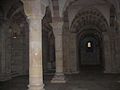
Speyer:
crypt of the cathedral with Salian burial place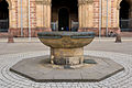
Speyer: Domnapf
fountain trough
Speyer:
"Jakobspilger" ( bronze cast by Martin Mayer )
Speyer:
City gate old gate
Speyer:
Judenbad (mikveh)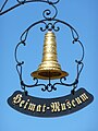
Schifferstadt
Golden Hat
Bad Dürkheim:
Limburg monastery ruins
Bad Dürkheim:
Hardenburg ruins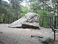
Bad Dürkheim:
Teufelsstein cult site
Bad Dürkheim:
Roman quarry Kriemhildenstuhl
Bad Dürkheim:
Heidenmauer Celtic settlement


.jpg)
.jpg)


Section 2
(new northern circuit, length 54.4 km)
- Birch heather
- Maxdorf
- Lambsheim : Neutorturm and other cultural monuments
- Frankenthal-Flomersheim
- Frankenthal : Erkenbert ruins and other cultural monuments
- Frankenthal-Mörsch
- Bobenheim-Roxheim : Old Rhine , Silbersee
- Worms : Imperial Cathedral and other cultural monuments
- Worms-Pfeddersheim : city wall with defense towers
- Worms-Heppenheim : Jewish cemetery
- Dirmstein : Laurentius Church and other cultural monuments (transition to Eckbach-Mühlenwanderweg )
- Heuchelheim : Jewish cemetery
- Hessheim
- Lambsheim (possibly further via Maxdorf and Birkenheide to Bad Dürkheim to section 1)

Lambsheim:
Neutorturm
Frankenthal:
Erkenbert ruin
Frankenthal:
Wormser Tor
Worms:
Nibelungen Bridge
Pfeddersheim:
defense tower
Heppenheim:
Jewish cemetery
Dirmstein:
transition to the Eckbach-Mühlenwanderweg
Dirmstein:
Laurentius Church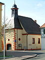
Dirmstein:
Spitalhof chapel
Heuchelheim:
Jewish cemetery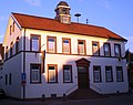
Heuchelheim:
Former school and town hall, today a local museum


Web links
Individual evidence
- ↑ a b Salier-Radweg on www.pfalz.de, accessed on June 29, 2018
- ↑ a b Salier Cycle Path - Kaiser Konrad Cycle Path at www.bad-duerkheim.com, accessed on June 29, 2018
- ↑ Salierradweg ( Memento of 14 October 2007 at the Internet Archive )
Coordinates: 49 ° 30 ′ 30.9 ″ N , 8 ° 16 ′ 58 ″ E