
Barbarossa cycle path
| Barbarossa cycle path | |
|---|---|

|
|
| overall length | 88 km |
| location | North Palatinate Bergland , Palatinate Forest and Wine Route / Rhineland-Palatinate |
| map | |
| Link to map and elevation profile | |
| Starting point | Glan-Münchweiler |
| Target point | Worms |
| Places along the way | Miesenbach , Rodenbach , Kaiserslautern , Enkenbach-Alsenborn , Eiswoog , Ramsen , Eisenberg , Asselheim , Offstein , Heppenheim an der Wiese |
| Flooring | Mostly paved, also coarser gravel. |
| Height difference | +800 m up / −920 m down |
| difficulty | Stronger gradients on 5 km in the Palatinate Forest. |
| Traffic volume | Mainly on forest and farm roads. |
| Website URL | radwanderland.de (PDF; 575 kB) |
The Barbarossa Cycle Path is an 88-kilometer cycle path that connects the North Palatinate Bergland with the old imperial city of Worms on the Rhine . In doing so, it crosses the varied landscape of the Palatinate (region) , largely with little incline, before reaching the Rhine plain, which is characterized by viticulture. It connects the Glan-Blies cycle path via the Barbarossa city of Kaiserslautern with the Rhine cycle path . The entire route is uniformly signposted with the bike path logo. The bike path logo shows the stylized emperor Barbarossa . The figure on the north portal of Worms Cathedral served as a template. Some sections are natural, so the bike path is not suitable for racing bikes or inline skaters.
Route
Glan-Münchweiler - Kaiserslautern
This section has a length of approx. 27 km. The starting point is the train station in Glan-Münchweiler ( 49 ° 28 ′ 13.7 ″ N , 7 ° 26 ′ 39.1 ″ E ). Together with the Glan-Blies cycle path , the path leads along the Glans , shortly after the Landstuhl – Kusel railway crossing , it branches off to the left in the direction of Niedermohr . From Niedermohr the route runs along the Mohrbach to Miesenbach . Past Seewoog, the path continues on farm roads and quiet country roads through Mackenbach , Rodenbach and Siegelbach to the northern edge of Kaiserslautern .
Kaiserslautern - Eisenberg
This section has a length of approx. 32 km. After crossing under the A 6 motorway to the south, the path leads along forest paths past the Vogelwoog and Hammerwoog , and then leads back to the north side of the motorway, where you turn into the Eselsbach valley. At the Waschmühle open-air swimming pool , the route follows a short stretch of road before it leads on forest paths through the Eselsbachtal nature reserve to Eselsfürth , a former site of the US armed forces. It continues on a cycle path alongside the road to Enkenbach-Alsenborn . The natural forest path from Alsenborn into the Eisbachtal requires rather wide tires. The route then follows the Eisbach on paved forest paths , past the Eiswoog and the village of Ramsen to Eisenberg .
Eisenberg - Worms
This section has a length of approx. 29 km. The next place after Eisenberg is Ebertsheim. From here the path leads on the country road via Mertesheim to Asselheim , from where it follows the Deutsche Weinstraße cycle path to Bockenheim . The cycle path runs through Bockenheim alongside the B271 before continuing in an easterly direction over the Riedweg to Hohen-Sülzen . The further route leads on mostly asphalted paths via Offstein into the Eisbachtal in the direction of Worms city center. Through rural districts, the route reaches the center of Worms and ends on the northeast side of the cathedral ( 49 ° 37 ′ 48.6 ″ N , 8 ° 21 ′ 35.2 ″ E ).
Landscape and culture

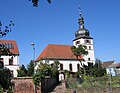
Rodenbacher bell tower
Protestant Church in Alsenborn
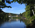
Recreation area Eiswoog in the stump forest

Womser Cathedral


.jpg)

The cycle path crosses the Palatinate from the Glantal in an easterly direction to Worms am Rhein. It starts in the so-called Kuseler Musikantenland in the North Palatinate Bergland and moves east between the Bergland and the Landstuhler Bruch . The Barbarossa city of Kaiserslautern is touched on its northern edge. From Enkenbach-Alsenborn the Lower Palatinate Forest ( stump forest ) is crossed before reaching the Rhine plain near Grünstadt . Through a landscape that is mainly characterized by viticulture (northern end of the German Wine Route near Bockenheim ), it goes to Worms.
The city founded by the Celts competes with Augsburg , Trier , Kempten and Regensburg for the title of the oldest city in Germany . Worms is known as the Nibelungen and Luther City and for its cathedral , which is one of the three Romanesque imperial cathedrals alongside the Mainz and Speyer cathedral .
Attractions
- Glan-Münchweiler : Protestant church and Roman four-god stones , museum about Jewish country life (see also list of cultural monuments in Glan-Münchweiler )
- Ramstein-Miesenbach : Catholic parish church St. Nikolaus, museum in Westrich , local recreation area Seewoog
- Mackenbach : West Palatinate Musicians Museum .
- Weilerbach : Reinhard Blauth Museum.
- Rodenbach : Celtic princely grave, Rodenbach sculpture trail
- Kaiserslautern : Japanese Garden , Casimir Castle , Imperial Palace , Theodor-Zink Museum , Wadgasserhof , Palatinate Gallery (see also the list of cultural monuments in Kaiserslautern ).
- Enkenbach-Alsenborn : Mehlinger Heide with Heideerlebnispfad, Bajasseum (circus museum), St. Norbert monastery church , Fritz-Walter-Museum (see also list of cultural monuments in Enkenbach-Alsenborn ).
- Eisenberg : local recreation area Eiswoog , Stauf Castle , Rosenthal monastery ruins , Roman park Vicus (see also list of cultural monuments in Eisenberg (Palatinate) ).
- Ramsen : Stumpfwaldbahn
- Bockenheim : House of the German Wine Route , Grape Madonna
- Worms : Kaiserdom , Nibelungen Museum (see also list of cultural monuments in Worms ).
Rail connection
Both endpoints of the cycle path, Glan-Münchweiler and Worms, are easily accessible by train. Until Miesbach the railway line accompanies the bike path. From Kaiserslautern there are train stations in almost all other places. Among others in Enkenbach-Alsenborn , Eiswoog , Ramsen and Eisenberg (Palatinate) . Glan-Münchweiler can be reached every hour from Kaiserslautern and Worms is connected every half hour via the main Mainz-Mannheim line.
Connection routes
- Glan-Blies-Radweg - connection in Glan-Münchweiler .
- Lautertal cycle path - connection in Kaiserslautern .
- Palatinate Forest Tour - connection in Kaiserslautern .
- Alsenz cycle path - connection in Alsenborn. It connects Enkenbach-Alsenborn with the Nahe valley .
- German Wine Route Cycle Route - connection in Asselheim and Bockenheim .
- Salier cycle path - connection in Worms-Heppenheim.
- Rhine cycle path - connection in Worms .
- Hessian long-distance cycle route R9 - connection on the eastern side of the Rhine in Worms. It leads to Obernburg am Main .
- Hessian long-distance cycle route R6 - connection in Worms. It crosses Hessen in a north-south direction.
See also:
literature
- Cycling and leisure map West Palatinate North . Scale 1: 50,000. 2nd Edition. Pietruska-Verlag, Rülzheim / Pfalz 2000, ISBN 3-927416-63-0 .
Web links
- Barbarossa cycle path on radreisen.wiki
- Barbarossa cycle path with map, GPS track and tourist information
swell
- Radwanderland.de Retrieved November 2011
Coordinates: 49 ° 28 '17.3 " N , 7 ° 26' 40.3" E