
Alsenz cycle path
| Alsenz cycle path | |
|---|---|

|
|
| overall length | 49 km |
| location |
|
| map | |
| Link on map | |
| Starting point | Enkenbach-Alsenborn |
| Target point | Bad Munster am Stein |
| Places along the way | Enkenbach-Alsenborn , Münchweiler , Langmeil, Alsenbrück , Winnweiler , Hochstein , Schweisweiler , Imsweiler , Rockenhausen , Dielkirchen , Bayerfeld-Steckweiler , Mannweiler-Cölln , Oberndorf (Palatinate) , Alsenz , Hochstätten , Altenbamberg , Bad Münster am Stein |
| Flooring | mostly paved |
| Height difference | Total gradient: 170 m Total gradient: 355 m |
| difficulty | medium |
| Traffic volume | low |
| Connection to |
Barbarossa cycle path , Nahe cycle path |
| Website URL |
radwanderland.de (PDF; 516 kB) |
The Alsenz cycle path is a 49 km long river cycle path with a few short climbs and a longer incline. It leads from the source of the Alsenz in Enkenbach-Alsenborn from the Palatinate Forest into the Nahe valley , where the Alsenz flows into the Nahe near Bad Münster am Stein . He bypasses the 686.5 m high Donnersberg in a wide arc. It runs over the open hilly landscape through fertile land and past vineyards always near the Alsenz river. The entire route is uniformly signposted with the bike path logo and is easy to drive in both directions. For nature conservation reasons, some sections are not paved, so it is not suitable for racing bikes or inline skaters.
Route
Alsenzquelle to Rockenhausen
This section has a length of approx. 24 km with +118 m ascent and −175 m descent. The route takes place on paved forest and field paths and through picturesque villages. Behind Imsweiler there are two steeper sections.
The path starts at the Alsenzquelle ( 49 ° 29 '28.5 " N , 7 ° 55' 25.3" O ) in Enkenbach-Alsenborn , the capital of Verbandsgemeinde . Enkenbach-Alsenborn can be reached by train via the Alsenz Valley Railway. This runs between Kaiserslautern and Bad Münster am Stein . The railway line accompanies the cycle path along the entire route. After Enkenbach-Alsenborn the route leads via Münchweiler , Langmeil and Alsenbrück to Winnweiler . Then it leads past the Bischoff private brewery over a narrow bridge to the historical building complex of the Gienanth iron smelter . After crossing the B 48 at Schweisweiler to Imsweiler, the route runs next to the main road. There is a well-known rococo church in Schweisweiler. From there the route runs on paved forest paths to the small town of Rockenhausen , which has a historic old town and several museums.
Rockenhausen to the mouth of the Nahe
This section has a length of approx. 25 km with +86 m ascent and −127 m descent. Here open hills and vineyards shape the landscape. The route is mostly off the road and is mostly paved.
From Rockenhausen the route takes place on farm roads via Dielkirchen and Bayerfeld-Steckweiler through the wine-growing area to Mannweiler-Cölln , whose higher-lying town center requires a certain amount of effort. The path then reaches the village of Oberndorf , whose simultaneous church is visible from afar. This is followed by the last ascent of around one kilometer. The cyclist is rewarded with a wonderful view of the Alsenz valley. After a two-kilometer descent, the route reaches Alsenz , where the historic market square and the Palatinate stone carving museum can be visited. From Alsenz the route leads via Hochstätten to Bad Münster am Stein , where the Alsenz confluence with the Nahe ( 49 ° 48 ′ 26.7 ″ N , 7 ° 50 ′ 33.7 ″ E ) and the connection to the Nahe cycle path are located .
landscape
The Alsenz rises on the northern edge of the Diemerstein Forest, which is part of the Palatinate Forest Nature Park . The source is at an altitude of 292 m above sea level. NN within the Alsenborn district ( Kaiserslautern district ). From there, the Alsenz flows mostly in a northerly direction through the North Palatinate Uplands , with the Donnersberg being bypassed in a western arc. The bike path runs close to the river for the entire route. The first part of the cycle path is characterized by forests, fields and picturesque town passages, while viticulture dominates the second section. The vineyards belong to the Nahe wine-growing region , although the places are in the Palatinate . The Nahe valley is with the Alsenz estuary at an altitude of 110 m above sea level. NN , reached in Münster am Stein .
Attractions
- Alsenz : Museum of local history, Palatinate stone carving museum and gallery in the stone carving museum, Protestant parish church ( see also: List of cultural monuments in Alsenz ).
- Dielkirchen : Protestant parish church ( see also: List of cultural monuments in Dielkirchen ).
- Imsbach : White Grube visitor mine, Palatinate mining museum ( see also: List of cultural monuments in Imsbach ).
- Katzenbach : Villa Rustica (excavations of a Roman manor). About one kilometer after Rockenhausen, a signposted bike path leads to Katzenbach. (Distance: approx. 1 km).
- Mannweiler-Cölln : Randeck Museum, Randeck castle ruins (see also the list of cultural monuments in Mannweiler-Cölln ).
- Münchweiler : First radio museum in Rhineland-Palatinate.
- Oberndorf : Simultankirche St. Valentin (see also list of cultural monuments in Oberndorf (Palatinate) ).
- Rockenhausen : Natural adventure pool, Kahnweilerhaus , Museum Pachen, local history museum, museum for time - Palatinate tower clock museum , Protestant parish church (see also list of cultural monuments in Rockenhausen ).
- Schweisweiler : Leo's Tenne (local history museum), Catholic rococo church of St. Agidius.
- Winnweiler : Bischoff private brewery , Jewish Museum of the North Palatinate, Museum forge Langmeil, Catholic parish church Herz Jesu, Kreuzkapelle (see also list of cultural monuments in Winnweiler ).

Alsenzquelle in the swimming pool of Alsenborn

Alsenz near Winnweiler
Alzenz near Oberndorf

Palatinate Tower Clock Museum in Rockenhausen

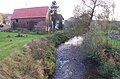
Bad Munster am Stein
.jpg)


Rail connection
Both endpoints of the cycle path, Enkenbach-Alsenborn and Bad Münster am Stein , are easily accessible by train. They can be reached at least every hour via Kaiserslautern or Bad Kreuznach . The Alsenz Valley Railway accompanies the cycle path along the entire route. The stops along the route are only a few kilometers apart.
Connection routes
- Barbarossa cycle path - connection in Alsenborn. It connects Glan-Münchweiler with Worms .
- Nahe cycle path - connection in Bad Münster am Stein .
See also:
literature
- Cycling and leisure map West Palatinate North . Scale 1: 50,000. Pietruska-Verlag, Rülzheim / Pfalz, 2nd edition 2000. ISBN 3-927 416-63-0
Web links
- History on interactive map , accessed May 6, 2013.
Coordinates: 49 ° 29 '26.5 " N , 7 ° 55' 16.8" E