
Nahe cycle path
| Nahe cycle path | |
|---|---|
| overall length | 128 km |
| location |
|
| Starting point |
Nohfelden / Bostalsee 49 ° 35 ′ 12.9 ″ N , 7 ° 8 ′ 34.2 ″ E |
| Target point |
Bingen am Rhein 49 ° 58 ′ 0.3 ″ N , 7 ° 54 ′ 16.5 ″ E |
| Places along the way | Selbach , Neunkirchen ad Nahe , Gonnesweiler , Türkismühle , Nohfelden , Neubrücke , Birkenfeld , Elchweiler , Kronweiler , Idar-Oberstein , Weierbach , Kirn , Bad Sobernheim , Staudernheim , Niederhausen , Bad Münster am Stein , Bad Kreuznach , Bretzenheim , Grolsheim , Dietersheim |
| Flooring | asphalt cycle, forest or farm roads |
| Height difference | Start at 464 m , end at 81 m +620 m ascent, -990 m descent. |
| Traffic volume | Mostly away from the highways. Sections on quiet country roads. |
| Website URL | Official website |

The approximately 128 kilometers long Nahe cycle path follows the course of the Nahe from its source in Saarland ( Nohfelden / Bostalsee ) to its confluence with the Rhine near Bingen . On the upper reaches of the Nahe, it crosses the wooded areas of the Saar-Hunsrück nature park . Between Kirn and the Rhine-Nahe triangle, grapevines characterize the Nahe valley in flat and hilly areas. The Nahe cycle path runs almost exclusively on paved bike , forest or farm roads . It is consistently marked with green and white signs . The logo of the Nahe cycle path shows a bicycle and a river course against a yellow background, it also bears the inscription “Radweg Nahe”. The cycle path is divided into six stages or - roughly speaking - into three sections with different degrees of difficulty.
geography
To the north of the cycle path is the Hunsrück , with the elevations of the Osburger Hochwald , Schwarzwälder Hochwald , Idarwald , Lützelsoon and Soonwald . To the south of it lies the Palatinate with the North Palatinate Bergland , Glantal and Alsenztal .
Routing

Section 1: From the source to Idar-Oberstein
The path begins at the Nahe spring north of Selbach . After around seven kilometers, it passes the Bostalsee, which is fed by Demelbach and Bosbach . Shortly after Nohfelden there is a short but steep ascent before reaching Rhineland-Palatinate . From Neubrücke the cycle path moves away from the Nahe valley and connects to Birkenfeld on a former railway line . Only at Kronweiler does he return to the course of the river. There are four more climbs to overcome to Idar-Oberstein . The approximately 49 km long tour from the Nahe spring near Selbach to the gemstone town of Idar-Oberstein is particularly suitable for sporty cyclists thanks to the short but steep climbs. It contains 460 meters of climbs and 660 meters of descents.
Section 2: From Idar-Oberstein to Bad Sobernheim
The second section of the Nahe cycle path runs for around 36 km to Bad Sobernheim . From Idar-Oberstein, the bike path runs flat through the wide Nahe valley, mostly lined with rocks, to Kirn . From Martinstein , the cycle path also leads along the first growing areas of the Nahe wine-growing region , connecting wine towns such as Merxheim and Meddersheim . In Bad Sobernheim this ends with 50 m ascent and 165 m of descents, family-friendly, flat river section of the Nahe cycle path.
Section 3: From Bad Sobernheim to Bingen am Rhein
The last section of the Nahe cycle path begins in Bad Sobernheim and ends in Bingen am Rhein (approx. 43 kilometers). At the beginning of this section of the bike path near touches Staudernheim the Disibodenberg . After the 500 m short but violent ascent to Schloßböckelheim , the Nahe valley can be seen for a long time. Past the Rotenfels and the rock formations of the Rheingrafenstein , it goes in wide arcs northeast. The Nahe valley thickens behind Bad Münster am Stein-Ebernburg . Passing the graduation towers in the Salinental you reach Bingen am Rhein via Bad Kreuznach and Gensingen . The cycle path officially ends at the Nahe confluence with the Rhine. Like the previous section, this part of the tour is family-friendly. There are 100 vertical meters of climbs and 170 vertical meters of descents to master.
Attractions
- The Bostalsee with a wide range of tourist attractions.
- The Veldenz Castle in Nohfelden .
- Birkenfeld - Museum, Castle and New Palace. (See also list of cultural monuments ).
- The castle Frombork near the village of Frauenberg .
- Idar-Oberstein - Felsenkirche , German Gemstone Museum .
- The historic copper mine near Fischbach was one of the largest and most valuable copper mining sites in Europe for centuries .
- Kirn - Kyrburg , access to the Hunsrück Slate and Castle Road .
- Bad Sobernheim - Rhineland-Palatinate open-air museum .
- The trolley service between Altenglan and Staudernheim .
- The ruins of the Disibodenberg monastery near Staudernheim .
- The Schmittenstollen visitor mine at the foot of the Lemberg near Niederhausen .
- Bad Münster am Stein - With the rock formations Rotenfels and Rheingrafenstein with the castle ruins of the same name . The Ebernburg with the Sickingen von Hutten monument. Also the stone sculpture park, the artist station . In the Salinental, the graduation towers extend for around 1.4 km from Bad Kreuznach to the spa area.
- Bad Kreuznach - Roman hall , palace park museum , museum for puppet theater culture , bridge houses from the 15th century.
- Bingen am Rhein - Historisches Museum am Strom Hildegard von Bingen , Klopp Castle , Mäuseturm and Binger Loch .
- Pictures on the way

Dusk at the Bostalsee
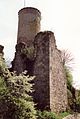
Veldenz castle ruins
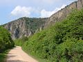
former Werkstrasse along Rotenfels

Idar-Oberstein rock church

Old Nahe bridge
in Bad Kreuznach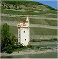
Binger mouse tower


Rail connection
Bingen at the confluence of the Nahe and the Rhine can be easily reached via the Mainz - Koblenz Rhine route . The Nahe is through the Nahe Valley Railway supplied optimally with rail connections. The Türkismühle train station is approx. 9 km from the Nahe spring.
Minor routes
There are a total of 19 secondary routes on the Nahe cycle path. Together these form a total length of 500 kilometers.
Supra-regional connections
- Glan-Blies cycle path from Staudernheim near Bad Sobernheim to Saargemünd ( France ), length approx. 125 km
- " Saar-Hunsrück Nature Park " cycle path from Fischbach (near Idar-Oberstein) to Losheim am See , length approx. 110 km
- Nahe-Hunsrück-Moselle cycle path from Bingen am Rhein to Trier , length approx. 207 km
- Velo Route Rhine from Bingen am Rhein , length approx. 330 km through Rhineland-Palatinate
- Saarland cycle path from Nohfelden / Bostalsee , length approx. 362 km
- Straight into the Hunsrück - via the Lützelsoon cycle path , the Schinderhannes-Soonwald cycle path and the Schinderhannes cycle path to Emmelshausen approx. 80 km
Bike adventure day
- “Nahe Hit - Rad'l mit”, third Sunday in June, car-free on the Nahe cycle path from Nohfelden / Bostalsee to Bingen am Rhein
See also
literature
- Cycling guide Nahe-Hunsrück-Mosel . Scale 1: 50,000. Galli publishing house, Neuburg a. d. D., 2nd edition 2001. ISBN 3931944638
- bikeline bike tour book Nahe-Radweg . Scale 1: 50,000. Verlag Esterbauer, 2nd edition 2002. ISBN 3850000389
- Nahe cycle path - from the source near Selbach to the confluence with the Rhine. Compact spiral 1: 50,000, BVA Bielefelder Verlag 2009, ISBN 978-3-87073-456-5
- Thorsten Brönner: Germany's most beautiful river bike paths. 15,000 fantastic river kilometers from the edge of the Alps to the North Sea beach. Bruckmann, Munich 2013, ISBN 978-3-7654-5107-2 , pp. 182-185.
Web links
- Cycling in Rhineland-Palatinate
- Nahe cycle path on radreisen.wiki
- Nahe cycle path near Hunsrück-Nahereise
- Tour planner Rhineland Palatinate - GPS data and tour description
- Connection to RegioRadler buses in Rhineland-Palatinate
Individual evidence
- ↑ Nahe cycle path . Website of the Ministry of the Interior, for Sport and Infrastructure Rhineland-Palatinate. Retrieved October 29, 2013.
- ↑ Nahe cycle path , from www.tourenplaner-rheinland-pfalz.de, accessed on May 25, 2018
- ↑ a b Nahe Cycle Path ( Memento from May 27, 2018 in the Internet Archive ) on adfc.de, accessed on October 17, 2018
- ↑ Nahe cycle path . Tour planner Rhineland-Palatinate. Retrieved October 29, 2013.
- ↑ Cycling events in the Nahe vacation region , on naheland.net, accessed on May 25, 2018